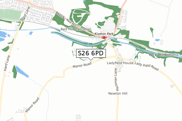
S26 6PD is located in the Wales electoral ward, within the metropolitan district of Rotherham and the English Parliamentary constituency of Rother Valley. The Sub Integrated Care Board (ICB) Location is NHS South Yorkshire ICB - 03L and the police force is South Yorkshire. This postcode has been in use since October 2018.


GetTheData
Source: OS Open Zoomstack (Ordnance Survey)
Licence: Open Government Licence (requires attribution)
Attribution: Contains OS data © Crown copyright and database right 2025
Source: Open Postcode Geo
Licence: Open Government Licence (requires attribution)
Attribution: Contains OS data © Crown copyright and database right 2025; Contains Royal Mail data © Royal Mail copyright and database right 2025; Source: Office for National Statistics licensed under the Open Government Licence v.3.0
| Easting | 450561 |
| Northing | 382158 |
| Latitude | 53.333944 |
| Longitude | -1.242207 |
GetTheData
Source: Open Postcode Geo
Licence: Open Government Licence
| Country | England |
| Postcode District | S26 |
➜ See where S26 is on a map ➜ Where is Kiveton Park? | |
GetTheData
Source: Land Registry Price Paid Data
Licence: Open Government Licence
| Ward | Wales |
| Constituency | Rother Valley |
GetTheData
Source: ONS Postcode Database
Licence: Open Government Licence
| Manor Road | Kiveton Park | 350m |
| Manor Road | Kiveton Park | 356m |
| Railway Station (Dog Kennels Lane) | Kiveton Park | 417m |
| Railway Station (Dog Kennels Lane) | Kiveton Park | 490m |
| Dog Kennels Lane | Kiveton Park | 632m |
| Kiveton Park Station | 0.3km |
| Kiveton Bridge Station | 1.8km |
| Shireoaks Station | 5km |
GetTheData
Source: NaPTAN
Licence: Open Government Licence
| Percentage of properties with Next Generation Access | 100.0% |
| Percentage of properties with Superfast Broadband | 100.0% |
| Percentage of properties with Ultrafast Broadband | 0.0% |
| Percentage of properties with Full Fibre Broadband | 0.0% |
Superfast Broadband is between 30Mbps and 300Mbps
Ultrafast Broadband is > 300Mbps
| Percentage of properties unable to receive 2Mbps | 0.0% |
| Percentage of properties unable to receive 5Mbps | 0.0% |
| Percentage of properties unable to receive 10Mbps | 0.0% |
| Percentage of properties unable to receive 30Mbps | 0.0% |
GetTheData
Source: Ofcom
Licence: Ofcom Terms of Use (requires attribution)
GetTheData
Source: ONS Postcode Database
Licence: Open Government Licence


➜ Get more ratings from the Food Standards Agency
GetTheData
Source: Food Standards Agency
Licence: FSA terms & conditions
| Last Collection | |||
|---|---|---|---|
| Location | Mon-Fri | Sat | Distance |
| Kiveton Park Station | 17:15 | 12:00 | 440m |
| Hard Lane | 16:30 | 12:00 | 1,155m |
| Kiveton Park Post Office | 17:15 | 11:30 | 1,550m |
GetTheData
Source: Dracos
Licence: Creative Commons Attribution-ShareAlike
The below table lists the International Territorial Level (ITL) codes (formerly Nomenclature of Territorial Units for Statistics (NUTS) codes) and Local Administrative Units (LAU) codes for S26 6PD:
| ITL 1 Code | Name |
|---|---|
| TLE | Yorkshire and The Humber |
| ITL 2 Code | Name |
| TLE3 | South Yorkshire |
| ITL 3 Code | Name |
| TLE31 | Barnsley, Doncaster and Rotherham |
| LAU 1 Code | Name |
| E08000018 | Rotherham |
GetTheData
Source: ONS Postcode Directory
Licence: Open Government Licence
The below table lists the Census Output Area (OA), Lower Layer Super Output Area (LSOA), and Middle Layer Super Output Area (MSOA) for S26 6PD:
| Code | Name | |
|---|---|---|
| OA | E00039246 | |
| LSOA | E01007752 | Rotherham 033D |
| MSOA | E02001610 | Rotherham 033 |
GetTheData
Source: ONS Postcode Directory
Licence: Open Government Licence
| S26 6PB | Manor Road | 313m |
| S26 6UY | Peck Mill View | 409m |
| S26 6NR | Ladyfield Road | 443m |
| S26 6NS | The Haven | 635m |
| S26 6NG | Dog Kennel Hill | 693m |
| S26 6NN | Holmes Field Close | 768m |
| S26 6PT | Penny Holme Close | 834m |
| S26 6NU | Latimer Close | 962m |
| S26 6QA | Red Hill | 971m |
| S26 6PR | Osborne Road | 1002m |
GetTheData
Source: Open Postcode Geo; Land Registry Price Paid Data
Licence: Open Government Licence