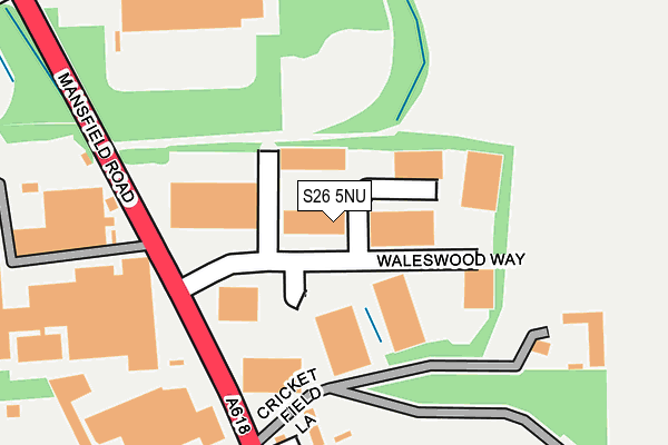
S26 5NU is located in the Wales electoral ward, within the metropolitan district of Rotherham and the English Parliamentary constituency of Rother Valley. The Sub Integrated Care Board (ICB) Location is NHS South Yorkshire ICB - 03L and the police force is South Yorkshire. This postcode has been in use since February 2006.


GetTheData
Source: OS OpenMap – Local (Ordnance Survey)
Source: OS VectorMap District (Ordnance Survey)
Licence: Open Government Licence (requires attribution)
| Easting | 446910 |
| Northing | 383386 |
| Latitude | 53.345297 |
| Longitude | -1.296846 |
GetTheData
Source: Open Postcode Geo
Licence: Open Government Licence
| Country | England |
| Postcode District | S26 |
➜ See where S26 is on a map ➜ Where is Wales? | |
GetTheData
Source: Land Registry Price Paid Data
Licence: Open Government Licence
Elevation or altitude of S26 5NU as distance above sea level:
| Metres | Feet | |
|---|---|---|
| Elevation | 90m | 295ft |
Elevation is measured from the approximate centre of the postcode, to the nearest point on an OS contour line from OS Terrain 50, which has contour spacing of ten vertical metres.
➜ How high above sea level am I? Find the elevation of your current position using your device's GPS.
GetTheData
Source: Open Postcode Elevation
Licence: Open Government Licence
| Ward | Wales |
| Constituency | Rother Valley |
GetTheData
Source: ONS Postcode Database
Licence: Open Government Licence
| Wales Common (Mansfield Road) | Wales Bar | 179m |
| East Terrace (Mansfield Road) | Wales Bar | 219m |
| Wales Common (Mansfield Road) | Wales Bar | 228m |
| Almond Tree Road (School Road) | Wales Bar | 445m |
| Waleswood Road (Mansfield Road) | Wales Bar | 455m |
| Kiveton Bridge Station | 2km |
| Kiveton Park Station | 3.9km |
| Woodhouse Station | 4.5km |
GetTheData
Source: NaPTAN
Licence: Open Government Licence
| Median download speed | 6.2Mbps |
| Average download speed | 6.1Mbps |
| Maximum download speed | 6.73Mbps |
| Median upload speed | 1.0Mbps |
| Average upload speed | 1.0Mbps |
| Maximum upload speed | 1.13Mbps |
GetTheData
Source: Ofcom
Licence: Ofcom Terms of Use (requires attribution)
GetTheData
Source: ONS Postcode Database
Licence: Open Government Licence


➜ Get more ratings from the Food Standards Agency
GetTheData
Source: Food Standards Agency
Licence: FSA terms & conditions
| Last Collection | |||
|---|---|---|---|
| Location | Mon-Fri | Sat | Distance |
| School Road | 17:30 | 11:30 | 505m |
| Wales Post Office | 17:15 | 11:45 | 942m |
| Robin Place | 17:30 | 10:30 | 1,439m |
GetTheData
Source: Dracos
Licence: Creative Commons Attribution-ShareAlike
The below table lists the International Territorial Level (ITL) codes (formerly Nomenclature of Territorial Units for Statistics (NUTS) codes) and Local Administrative Units (LAU) codes for S26 5NU:
| ITL 1 Code | Name |
|---|---|
| TLE | Yorkshire and The Humber |
| ITL 2 Code | Name |
| TLE3 | South Yorkshire |
| ITL 3 Code | Name |
| TLE31 | Barnsley, Doncaster and Rotherham |
| LAU 1 Code | Name |
| E08000018 | Rotherham |
GetTheData
Source: ONS Postcode Directory
Licence: Open Government Licence
The below table lists the Census Output Area (OA), Lower Layer Super Output Area (LSOA), and Middle Layer Super Output Area (MSOA) for S26 5NU:
| Code | Name | |
|---|---|---|
| OA | E00039269 | |
| LSOA | E01007750 | Rotherham 031D |
| MSOA | E02001608 | Rotherham 031 |
GetTheData
Source: ONS Postcode Directory
Licence: Open Government Licence
| S26 5RP | Wallingfield Court | 193m |
| S26 5RL | Waleswood Villas | 292m |
| S26 5LX | East Terrace | 317m |
| S26 5PE | Mansfield Road | 387m |
| S26 5QL | South Terrace | 409m |
| S26 5LB | Almond Tree Road | 538m |
| S26 5QJ | School Road | 547m |
| S26 5LZ | Fir Tree Drive | 571m |
| S26 5NA | Green Oak Drive | 622m |
| S26 5LL | Cherry Tree Road | 657m |
GetTheData
Source: Open Postcode Geo; Land Registry Price Paid Data
Licence: Open Government Licence