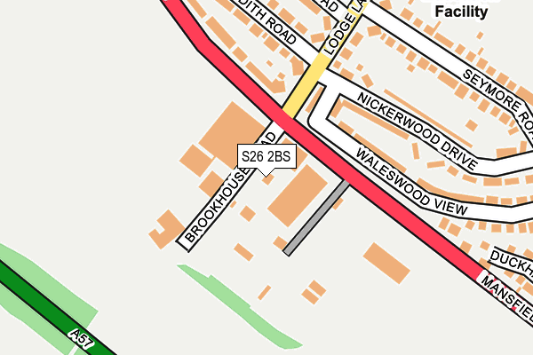
S26 2BS is located in the Aston & Todwick electoral ward, within the metropolitan district of Rotherham and the English Parliamentary constituency of Rother Valley. The Sub Integrated Care Board (ICB) Location is NHS South Yorkshire ICB - 03L and the police force is South Yorkshire. This postcode has been in use since June 1997.


GetTheData
Source: OS OpenMap – Local (Ordnance Survey)
Source: OS VectorMap District (Ordnance Survey)
Licence: Open Government Licence (requires attribution)
| Easting | 445795 |
| Northing | 384700 |
| Latitude | 53.357223 |
| Longitude | -1.313403 |
GetTheData
Source: Open Postcode Geo
Licence: Open Government Licence
| Country | England |
| Postcode District | S26 |
➜ See where S26 is on a map ➜ Where is Aston? | |
GetTheData
Source: Land Registry Price Paid Data
Licence: Open Government Licence
Elevation or altitude of S26 2BS as distance above sea level:
| Metres | Feet | |
|---|---|---|
| Elevation | 90m | 295ft |
Elevation is measured from the approximate centre of the postcode, to the nearest point on an OS contour line from OS Terrain 50, which has contour spacing of ten vertical metres.
➜ How high above sea level am I? Find the elevation of your current position using your device's GPS.
GetTheData
Source: Open Postcode Elevation
Licence: Open Government Licence
| Ward | Aston & Todwick |
| Constituency | Rother Valley |
GetTheData
Source: ONS Postcode Database
Licence: Open Government Licence
| Lodge Lane (Mansfield Road) | Aston | 49m |
| Nickerwood Drive (Lodge Lane) | Aston | 104m |
| Lodge Lane (Mansfield Road) | Aston | 110m |
| Waleswood View (Mansfield Road) | Aston | 145m |
| Waleswood View (Mansfield Road) | Aston | 150m |
| Woodhouse Station | 3km |
| Kiveton Bridge Station | 3.6km |
| Kiveton Park Station | 5.4km |
GetTheData
Source: NaPTAN
Licence: Open Government Licence
GetTheData
Source: ONS Postcode Database
Licence: Open Government Licence


➜ Get more ratings from the Food Standards Agency
GetTheData
Source: Food Standards Agency
Licence: FSA terms & conditions
| Last Collection | |||
|---|---|---|---|
| Location | Mon-Fri | Sat | Distance |
| 109 Mansfield Road | 17:45 | 11:15 | 138m |
| 30 Lodge Lane | 17:45 | 11:15 | 554m |
| Robin Place | 17:30 | 10:30 | 629m |
GetTheData
Source: Dracos
Licence: Creative Commons Attribution-ShareAlike
The below table lists the International Territorial Level (ITL) codes (formerly Nomenclature of Territorial Units for Statistics (NUTS) codes) and Local Administrative Units (LAU) codes for S26 2BS:
| ITL 1 Code | Name |
|---|---|
| TLE | Yorkshire and The Humber |
| ITL 2 Code | Name |
| TLE3 | South Yorkshire |
| ITL 3 Code | Name |
| TLE31 | Barnsley, Doncaster and Rotherham |
| LAU 1 Code | Name |
| E08000018 | Rotherham |
GetTheData
Source: ONS Postcode Directory
Licence: Open Government Licence
The below table lists the Census Output Area (OA), Lower Layer Super Output Area (LSOA), and Middle Layer Super Output Area (MSOA) for S26 2BS:
| Code | Name | |
|---|---|---|
| OA | E00038866 | |
| LSOA | E01007674 | Rotherham 031B |
| MSOA | E02001608 | Rotherham 031 |
GetTheData
Source: ONS Postcode Directory
Licence: Open Government Licence
| S26 2BR | Mansfield Road | 132m |
| S26 2BN | Lodge Lane | 177m |
| S26 2BX | Nickerwood Drive | 177m |
| S26 2DG | Seymore Road | 221m |
| S26 2BJ | Judith Road | 229m |
| S26 2DT | Waleswood View | 229m |
| S26 2BA | Elizabeth Road | 256m |
| S26 2BU | Margaret Close | 276m |
| S26 2DZ | Duckham Drive | 294m |
| S26 2AB | Ashley Grove | 340m |
GetTheData
Source: Open Postcode Geo; Land Registry Price Paid Data
Licence: Open Government Licence