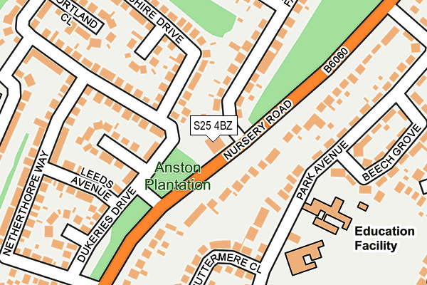
S25 4BZ is located in the Anston & Woodsetts electoral ward, within the metropolitan district of Rotherham and the English Parliamentary constituency of Rother Valley. The Sub Integrated Care Board (ICB) Location is NHS South Yorkshire ICB - 03L and the police force is South Yorkshire. This postcode has been in use since June 1997.


GetTheData
Source: OS OpenMap – Local (Ordnance Survey)
Source: OS VectorMap District (Ordnance Survey)
Licence: Open Government Licence (requires attribution)
| Easting | 452346 |
| Northing | 385323 |
| Latitude | 53.362197 |
| Longitude | -1.214882 |
GetTheData
Source: Open Postcode Geo
Licence: Open Government Licence
| Country | England |
| Postcode District | S25 |
➜ See where S25 is on a map ➜ Where is Dinnington? | |
GetTheData
Source: Land Registry Price Paid Data
Licence: Open Government Licence
Elevation or altitude of S25 4BZ as distance above sea level:
| Metres | Feet | |
|---|---|---|
| Elevation | 120m | 394ft |
Elevation is measured from the approximate centre of the postcode, to the nearest point on an OS contour line from OS Terrain 50, which has contour spacing of ten vertical metres.
➜ How high above sea level am I? Find the elevation of your current position using your device's GPS.
GetTheData
Source: Open Postcode Elevation
Licence: Open Government Licence
| Ward | Anston & Woodsetts |
| Constituency | Rother Valley |
GetTheData
Source: ONS Postcode Database
Licence: Open Government Licence
| Falcon Way (Nursery Road) | North Anston | 44m |
| Falcon Way (Nursery Road) | North Anston | 78m |
| Park Avenue (Nursery Road) | Dinnington | 215m |
| Walnut Drive (Nursery Road) | Dinnington | 369m |
| Thirlmere Drive (Lakeland Drive) | North Anston | 402m |
| Kiveton Park Station | 3.3km |
| Kiveton Bridge Station | 4.2km |
| Shireoaks Station | 5.2km |
GetTheData
Source: NaPTAN
Licence: Open Government Licence
GetTheData
Source: ONS Postcode Database
Licence: Open Government Licence


➜ Get more ratings from the Food Standards Agency
GetTheData
Source: Food Standards Agency
Licence: FSA terms & conditions
| Last Collection | |||
|---|---|---|---|
| Location | Mon-Fri | Sat | Distance |
| 1 Falcon Way | 17:30 | 12:00 | 26m |
| Lakeland Drive | 17:30 | 12:15 | 401m |
| Nursery Crescent | 17:30 | 12:00 | 452m |
GetTheData
Source: Dracos
Licence: Creative Commons Attribution-ShareAlike
The below table lists the International Territorial Level (ITL) codes (formerly Nomenclature of Territorial Units for Statistics (NUTS) codes) and Local Administrative Units (LAU) codes for S25 4BZ:
| ITL 1 Code | Name |
|---|---|
| TLE | Yorkshire and The Humber |
| ITL 2 Code | Name |
| TLE3 | South Yorkshire |
| ITL 3 Code | Name |
| TLE31 | Barnsley, Doncaster and Rotherham |
| LAU 1 Code | Name |
| E08000018 | Rotherham |
GetTheData
Source: ONS Postcode Directory
Licence: Open Government Licence
The below table lists the Census Output Area (OA), Lower Layer Super Output Area (LSOA), and Middle Layer Super Output Area (MSOA) for S25 4BZ:
| Code | Name | |
|---|---|---|
| OA | E00038801 | |
| LSOA | E01007657 | Rotherham 029A |
| MSOA | E02001606 | Rotherham 029 |
GetTheData
Source: ONS Postcode Directory
Licence: Open Government Licence
| S25 4BT | Nursery Road | 92m |
| S25 4DS | Scarborough Close | 129m |
| S25 4AS | Dukeries Drive | 146m |
| S25 4AR | Devonshire Drive | 153m |
| S25 4GA | Buttermere Close | 175m |
| S25 4BL | Newcastle Close | 183m |
| S25 4FA | Leeds Avenue | 190m |
| S25 4AP | Devonshire Drive | 212m |
| S25 4FH | Manvers Close | 233m |
| S25 4AQ | Devonshire Drive | 234m |
GetTheData
Source: Open Postcode Geo; Land Registry Price Paid Data
Licence: Open Government Licence