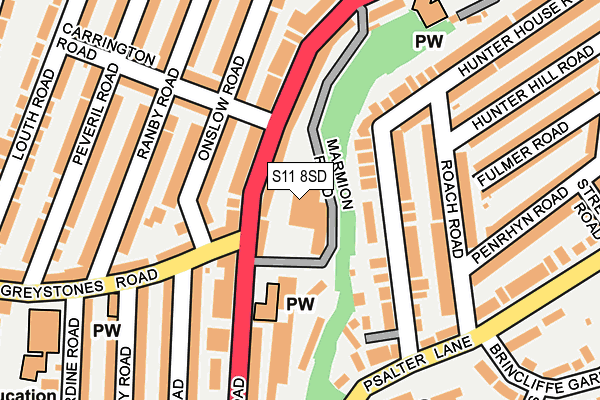
S11 8SD is located in the Ecclesall electoral ward, within the metropolitan district of Sheffield and the English Parliamentary constituency of Sheffield, Hallam. The Sub Integrated Care Board (ICB) Location is NHS South Yorkshire ICB - 03N and the police force is South Yorkshire. This postcode has been in use since January 1980.


GetTheData
Source: OS OpenMap – Local (Ordnance Survey)
Source: OS VectorMap District (Ordnance Survey)
Licence: Open Government Licence (requires attribution)
| Easting | 432888 |
| Northing | 385429 |
| Latitude | 53.364732 |
| Longitude | -1.507242 |
GetTheData
Source: Open Postcode Geo
Licence: Open Government Licence
| Country | England |
| Postcode District | S11 |
➜ See where S11 is on a map ➜ Where is Sheffield? | |
GetTheData
Source: Land Registry Price Paid Data
Licence: Open Government Licence
Elevation or altitude of S11 8SD as distance above sea level:
| Metres | Feet | |
|---|---|---|
| Elevation | 130m | 427ft |
Elevation is measured from the approximate centre of the postcode, to the nearest point on an OS contour line from OS Terrain 50, which has contour spacing of ten vertical metres.
➜ How high above sea level am I? Find the elevation of your current position using your device's GPS.
GetTheData
Source: Open Postcode Elevation
Licence: Open Government Licence
| Ward | Ecclesall |
| Constituency | Sheffield, Hallam |
GetTheData
Source: ONS Postcode Database
Licence: Open Government Licence
| Carrington Road (Ecclesall Road) | Hunters Bar | 55m |
| Greystones Road (Ecclesall Road) | Hunters Bar | 60m |
| Carrington Road (Ecclesall Road) | Hunters Bar | 107m |
| Ecclesall Road (Greystones Road) | Greystones | 108m |
| Onslow Road (Greystones Road) | Greystones | 132m |
| Sheffield Station | 3.4km |
| Dore & Totley Station | 4.2km |
GetTheData
Source: NaPTAN
Licence: Open Government Licence
GetTheData
Source: ONS Postcode Database
Licence: Open Government Licence


➜ Get more ratings from the Food Standards Agency
GetTheData
Source: Food Standards Agency
Licence: FSA terms & conditions
| Last Collection | |||
|---|---|---|---|
| Location | Mon-Fri | Sat | Distance |
| Endcliffe Park Post Office | 17:30 | 10:00 | 181m |
| 52 Greystones Road | 17:30 | 09:15 | 194m |
| 89 Penrhyn Road | 17:30 | 10:45 | 306m |
GetTheData
Source: Dracos
Licence: Creative Commons Attribution-ShareAlike
The below table lists the International Territorial Level (ITL) codes (formerly Nomenclature of Territorial Units for Statistics (NUTS) codes) and Local Administrative Units (LAU) codes for S11 8SD:
| ITL 1 Code | Name |
|---|---|
| TLE | Yorkshire and The Humber |
| ITL 2 Code | Name |
| TLE3 | South Yorkshire |
| ITL 3 Code | Name |
| TLE32 | Sheffield |
| LAU 1 Code | Name |
| E08000019 | Sheffield |
GetTheData
Source: ONS Postcode Directory
Licence: Open Government Licence
The below table lists the Census Output Area (OA), Lower Layer Super Output Area (LSOA), and Middle Layer Super Output Area (MSOA) for S11 8SD:
| Code | Name | |
|---|---|---|
| OA | E00040780 | |
| LSOA | E01008050 | Sheffield 046E |
| MSOA | E02001656 | Sheffield 046 |
GetTheData
Source: ONS Postcode Directory
Licence: Open Government Licence
| S11 8TH | Ecclesall Road | 47m |
| S11 8TD | Ecclesall Road | 65m |
| S11 8TY | Hunter House Road | 82m |
| S11 7AG | Onslow Road | 92m |
| S11 8TX | Hunter House Road | 113m |
| S11 7AS | Carrington Road | 136m |
| S11 8TZ | Hunter House Road | 143m |
| S11 8PU | Psalter Croft | 150m |
| S11 7AN | Ranby Road | 153m |
| S11 8TB | Ecclesall Road | 154m |
GetTheData
Source: Open Postcode Geo; Land Registry Price Paid Data
Licence: Open Government Licence