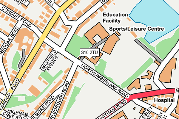
S10 2TU is located in the Broomhill and Sharrow Vale electoral ward, within the metropolitan district of Sheffield and the English Parliamentary constituency of Sheffield Central. The Sub Integrated Care Board (ICB) Location is NHS South Yorkshire ICB - 03N and the police force is South Yorkshire. This postcode has been in use since January 1995.


GetTheData
Source: OS OpenMap – Local (Ordnance Survey)
Source: OS VectorMap District (Ordnance Survey)
Licence: Open Government Licence (requires attribution)
| Easting | 433615 |
| Northing | 387364 |
| Latitude | 53.382061 |
| Longitude | -1.496114 |
GetTheData
Source: Open Postcode Geo
Licence: Open Government Licence
| Country | England |
| Postcode District | S10 |
➜ See where S10 is on a map ➜ Where is Sheffield? | |
GetTheData
Source: Land Registry Price Paid Data
Licence: Open Government Licence
Elevation or altitude of S10 2TU as distance above sea level:
| Metres | Feet | |
|---|---|---|
| Elevation | 140m | 459ft |
Elevation is measured from the approximate centre of the postcode, to the nearest point on an OS contour line from OS Terrain 50, which has contour spacing of ten vertical metres.
➜ How high above sea level am I? Find the elevation of your current position using your device's GPS.
GetTheData
Source: Open Postcode Elevation
Licence: Open Government Licence
| Ward | Broomhill And Sharrow Vale |
| Constituency | Sheffield Central |
GetTheData
Source: ONS Postcode Database
Licence: Open Government Licence
| Northumberland Road (Whitham Road) | Western Bank | 172m |
| Northumberland Road (Crookesmoor Road) | Crookesmoor | 176m |
| Conduit Road (Crookesmoor Road) | Crookesmoor | 193m |
| Northumberland Road (Whitham Road) | Western Bank | 207m |
| Moor Oaks Road (Whitham Road) | Broomhill | 315m |
| University Of Sheffield (Sheffield Supertram) (Hanover Street) | Western Bank | 816m |
| Netherthorpe Road (Sheffield Supertram) (Netherthorpe Road) | Netherthorpe | 952m |
| West Street (Sheffield Supertram) (West Street) | Sheffield Centre | 1,251m |
| Infirmary Road (Sheffield Supertram) (Infirmary Road) | Upperthorpe | 1,337m |
| Shalesmoor (Sheffield Supertram) (Corner Of Netherthorpe Rd And Shalesmoor) | Shalesmoor | 1,415m |
| Sheffield Station | 2.3km |
GetTheData
Source: NaPTAN
Licence: Open Government Licence
GetTheData
Source: ONS Postcode Database
Licence: Open Government Licence


➜ Get more ratings from the Food Standards Agency
GetTheData
Source: Food Standards Agency
Licence: FSA terms & conditions
| Last Collection | |||
|---|---|---|---|
| Location | Mon-Fri | Sat | Distance |
| 348 Crookesmoor Road | 17:30 | 11:30 | 189m |
| Jessops Wing | 16:30 | 11:45 | 306m |
| 136 Whitham Road | 18:00 | 09:30 | 378m |
GetTheData
Source: Dracos
Licence: Creative Commons Attribution-ShareAlike
The below table lists the International Territorial Level (ITL) codes (formerly Nomenclature of Territorial Units for Statistics (NUTS) codes) and Local Administrative Units (LAU) codes for S10 2TU:
| ITL 1 Code | Name |
|---|---|
| TLE | Yorkshire and The Humber |
| ITL 2 Code | Name |
| TLE3 | South Yorkshire |
| ITL 3 Code | Name |
| TLE32 | Sheffield |
| LAU 1 Code | Name |
| E08000019 | Sheffield |
GetTheData
Source: ONS Postcode Directory
Licence: Open Government Licence
The below table lists the Census Output Area (OA), Lower Layer Super Output Area (LSOA), and Middle Layer Super Output Area (MSOA) for S10 2TU:
| Code | Name | |
|---|---|---|
| OA | E00040903 | |
| LSOA | E01008067 | Sheffield 030D |
| MSOA | E02001640 | Sheffield 030 |
GetTheData
Source: ONS Postcode Directory
Licence: Open Government Licence
| S10 1DF | Northumberland Road | 138m |
| S10 1DG | Harcourt Crescent | 157m |
| S10 1BG | Crookesmoor Road | 166m |
| S10 1BH | Crookesmoor Road | 198m |
| S10 1DH | Harcourt Road | 198m |
| S10 1DA | Marlborough Road | 217m |
| S10 1BY | Elmore Road | 222m |
| S10 1DB | Marlborough Road | 231m |
| S10 1BJ | Crookesmoor Road | 241m |
| S10 1BD | Crookesmoor Road | 252m |
GetTheData
Source: Open Postcode Geo; Land Registry Price Paid Data
Licence: Open Government Licence