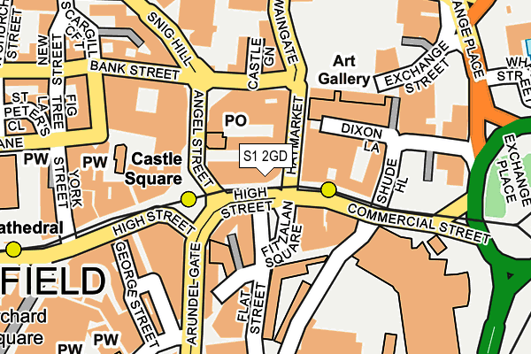
S1 2GD is located in the City electoral ward, within the metropolitan district of Sheffield and the English Parliamentary constituency of Sheffield Central. The Sub Integrated Care Board (ICB) Location is NHS South Yorkshire ICB - 03N and the police force is South Yorkshire. This postcode has been in use since January 1980.


GetTheData
Source: OS OpenMap – Local (Ordnance Survey)
Source: OS VectorMap District (Ordnance Survey)
Licence: Open Government Licence (requires attribution)
| Easting | 435676 |
| Northing | 387516 |
| Latitude | 53.383310 |
| Longitude | -1.465113 |
GetTheData
Source: Open Postcode Geo
Licence: Open Government Licence
| Country | England |
| Postcode District | S1 |
➜ See where S1 is on a map ➜ Where is Sheffield? | |
GetTheData
Source: Land Registry Price Paid Data
Licence: Open Government Licence
Elevation or altitude of S1 2GD as distance above sea level:
| Metres | Feet | |
|---|---|---|
| Elevation | 60m | 197ft |
Elevation is measured from the approximate centre of the postcode, to the nearest point on an OS contour line from OS Terrain 50, which has contour spacing of ten vertical metres.
➜ How high above sea level am I? Find the elevation of your current position using your device's GPS.
GetTheData
Source: Open Postcode Elevation
Licence: Open Government Licence
| Ward | City |
| Constituency | Sheffield Central |
GetTheData
Source: ONS Postcode Database
Licence: Open Government Licence
| Cg21 (Haymarket) | Sheffield Centre | 80m |
| Cg3 (Angel Street) | Sheffield Centre | 95m |
| Cg20 (Haymarket) | Sheffield Centre | 95m |
| Cg4 (Angel Street) | Sheffield Centre | 109m |
| Cg10 (Castle Street) | Sheffield Centre | 113m |
| Castle Square (Sheffield Supertram) (Jct Of Arundel Gate And Angel Street) | Sheffield Centre | 67m |
| Fitzalan Sq - Ponds Forge (Sheffield Supertram) (Commercial Street) | Sheffield Centre | 83m |
| Cathedral (Sheffield Supertram) (Church Street) | Sheffield Centre | 273m |
| City Hall (Sheffield Supertram) (West Street) | Sheffield Centre | 543m |
| Sheffield Stn - Hallam Uni (Supertram) (Off Sheaf Street) | Sheffield Centre | 659m |
| Sheffield Station | 0.6km |
| Darnall Station | 3.5km |
| Meadowhall Station | 5.2km |
GetTheData
Source: NaPTAN
Licence: Open Government Licence
| Percentage of properties with Next Generation Access | 0.0% |
| Percentage of properties with Superfast Broadband | 0.0% |
| Percentage of properties with Ultrafast Broadband | 0.0% |
| Percentage of properties with Full Fibre Broadband | 0.0% |
Superfast Broadband is between 30Mbps and 300Mbps
Ultrafast Broadband is > 300Mbps
| Percentage of properties unable to receive 2Mbps | 0.0% |
| Percentage of properties unable to receive 5Mbps | 0.0% |
| Percentage of properties unable to receive 10Mbps | 0.0% |
| Percentage of properties unable to receive 30Mbps | 100.0% |
GetTheData
Source: Ofcom
Licence: Ofcom Terms of Use (requires attribution)
GetTheData
Source: ONS Postcode Database
Licence: Open Government Licence


➜ Get more ratings from the Food Standards Agency
GetTheData
Source: Food Standards Agency
Licence: FSA terms & conditions
| Last Collection | |||
|---|---|---|---|
| Location | Mon-Fri | Sat | Distance |
| Sheffield Co-op | 18:30 | 12:00 | 59m |
| Royal Mail Building | 18:30 | 11:30 | 188m |
| Royal Mail Buildings | 18:30 | 11:30 | 188m |
GetTheData
Source: Dracos
Licence: Creative Commons Attribution-ShareAlike
The below table lists the International Territorial Level (ITL) codes (formerly Nomenclature of Territorial Units for Statistics (NUTS) codes) and Local Administrative Units (LAU) codes for S1 2GD:
| ITL 1 Code | Name |
|---|---|
| TLE | Yorkshire and The Humber |
| ITL 2 Code | Name |
| TLE3 | South Yorkshire |
| ITL 3 Code | Name |
| TLE32 | Sheffield |
| LAU 1 Code | Name |
| E08000019 | Sheffield |
GetTheData
Source: ONS Postcode Directory
Licence: Open Government Licence
The below table lists the Census Output Area (OA), Lower Layer Super Output Area (LSOA), and Middle Layer Super Output Area (MSOA) for S1 2GD:
| Code | Name | |
|---|---|---|
| OA | E00172408 | |
| LSOA | E01033264 | Sheffield 073D |
| MSOA | E02006843 | Sheffield 073 |
GetTheData
Source: ONS Postcode Directory
Licence: Open Government Licence
| S1 2AW | Haymarket | 72m |
| S1 2GF | Castle Square | 74m |
| S1 2GH | Market Place | 81m |
| S1 2AY | Fitzalan Square | 83m |
| S3 8LT | Castle Street | 122m |
| S1 2EP | High Court | 134m |
| S1 2AL | Dixon Lane | 136m |
| S1 2AR | Shude Hill | 143m |
| S1 2EL | Hartshead | 166m |
| S1 2GA | High Street | 176m |
GetTheData
Source: Open Postcode Geo; Land Registry Price Paid Data
Licence: Open Government Licence