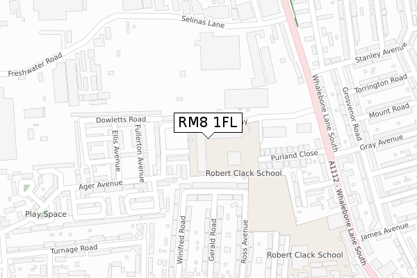
RM8 1FL is located in the Whalebone electoral ward, within the London borough of Barking and Dagenham and the English Parliamentary constituency of Dagenham and Rainham. The Sub Integrated Care Board (ICB) Location is NHS North East London ICB - A3A8R and the police force is Metropolitan Police. This postcode has been in use since September 2018.


GetTheData
Source: OS Open Zoomstack (Ordnance Survey)
Licence: Open Government Licence (requires attribution)
Attribution: Contains OS data © Crown copyright and database right 2025
Source: Open Postcode Geo
Licence: Open Government Licence (requires attribution)
Attribution: Contains OS data © Crown copyright and database right 2025; Contains Royal Mail data © Royal Mail copyright and database right 2025; Source: Office for National Statistics licensed under the Open Government Licence v.3.0
| Easting | 548608 |
| Northing | 187334 |
| Latitude | 51.565307 |
| Longitude | 0.142681 |
GetTheData
Source: Open Postcode Geo
Licence: Open Government Licence
| Country | England |
| Postcode District | RM8 |
➜ See where RM8 is on a map ➜ Where is London? | |
GetTheData
Source: Land Registry Price Paid Data
Licence: Open Government Licence
| Ward | Whalebone |
| Constituency | Dagenham And Rainham |
GetTheData
Source: ONS Postcode Database
Licence: Open Government Licence
| Stanley Avenue (Whalebone Lane South) | Beacontree Heath | 211m |
| Stanley Avenue | Beacontree Heath | 242m |
| James Avenue | Beacontree Heath | 340m |
| James Avenue (Whalebone Lane South) | Beacontree Heath | 372m |
| Winifred Road | Becontree | 458m |
| Chadwell Heath Station | 1km |
| Goodmayes Station | 2.2km |
| Romford Station | 3km |
GetTheData
Source: NaPTAN
Licence: Open Government Licence
GetTheData
Source: ONS Postcode Database
Licence: Open Government Licence


➜ Get more ratings from the Food Standards Agency
GetTheData
Source: Food Standards Agency
Licence: FSA terms & conditions
| Last Collection | |||
|---|---|---|---|
| Location | Mon-Fri | Sat | Distance |
| Gray Avenue | 17:30 | 12:15 | 283m |
| Baron Road | 17:30 | 12:15 | 1,119m |
| Ilchester Road | 17:15 | 12:15 | 1,141m |
GetTheData
Source: Dracos
Licence: Creative Commons Attribution-ShareAlike
The below table lists the International Territorial Level (ITL) codes (formerly Nomenclature of Territorial Units for Statistics (NUTS) codes) and Local Administrative Units (LAU) codes for RM8 1FL:
| ITL 1 Code | Name |
|---|---|
| TLI | London |
| ITL 2 Code | Name |
| TLI5 | Outer London - East and North East |
| ITL 3 Code | Name |
| TLI52 | Barking & Dagenham and Havering |
| LAU 1 Code | Name |
| E09000002 | Barking and Dagenham |
GetTheData
Source: ONS Postcode Directory
Licence: Open Government Licence
The below table lists the Census Output Area (OA), Lower Layer Super Output Area (LSOA), and Middle Layer Super Output Area (MSOA) for RM8 1FL:
| Code | Name | |
|---|---|---|
| OA | E00000556 | |
| LSOA | E01000109 | Barking and Dagenham 004D |
| MSOA | E02000005 | Barking and Dagenham 004 |
GetTheData
Source: ONS Postcode Directory
Licence: Open Government Licence
| RM8 1PS | Lamberhurst Road | 138m |
| RM8 1AS | Purland Close | 157m |
| RM8 1PR | Lamberhurst Road | 158m |
| RM8 1AT | Whalebone Lane South | 209m |
| RM8 1AR | Rosemary Gardens | 236m |
| RM8 1BA | Whalebone Lane South | 237m |
| RM8 1EP | Vaughn Street | 244m |
| RM8 1EQ | Ager Avenue | 247m |
| RM8 1PT | Gerald Road | 269m |
| RM8 1NJ | Grosvenor Road | 276m |
GetTheData
Source: Open Postcode Geo; Land Registry Price Paid Data
Licence: Open Government Licence