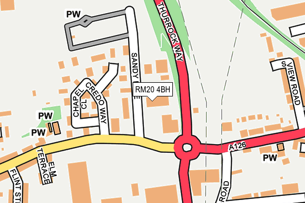
RM20 4BH is located in the West Thurrock and South Stifford electoral ward, within the unitary authority of Thurrock and the English Parliamentary constituency of Thurrock. The Sub Integrated Care Board (ICB) Location is NHS Mid and South Essex ICB - 07G and the police force is Essex. This postcode has been in use since December 1995.


GetTheData
Source: OS OpenMap – Local (Ordnance Survey)
Source: OS VectorMap District (Ordnance Survey)
Licence: Open Government Licence (requires attribution)
| Easting | 558928 |
| Northing | 177827 |
| Latitude | 51.477081 |
| Longitude | 0.287167 |
GetTheData
Source: Open Postcode Geo
Licence: Open Government Licence
| Country | England |
| Postcode District | RM20 |
➜ See where RM20 is on a map ➜ Where is West Thurrock? | |
GetTheData
Source: Land Registry Price Paid Data
Licence: Open Government Licence
Elevation or altitude of RM20 4BH as distance above sea level:
| Metres | Feet | |
|---|---|---|
| Elevation | 10m | 33ft |
Elevation is measured from the approximate centre of the postcode, to the nearest point on an OS contour line from OS Terrain 50, which has contour spacing of ten vertical metres.
➜ How high above sea level am I? Find the elevation of your current position using your device's GPS.
GetTheData
Source: Open Postcode Elevation
Licence: Open Government Licence
| Ward | West Thurrock And South Stifford |
| Constituency | Thurrock |
GetTheData
Source: ONS Postcode Database
Licence: Open Government Licence
| West Thurrock Way | West Thurrock | 51m |
| Ikea (West Thurrock Way) | West Thurrock | 218m |
| The Ship (London Road) | West Thurrock | 241m |
| Ikea (West Thurrock Way) | West Thurrock | 251m |
| The Ship (London Road) | West Thurrock | 254m |
| Chafford Hundred Station | 0.9km |
| Grays Station | 2.4km |
| Greenhithe for Bluewater Station | 3km |
GetTheData
Source: NaPTAN
Licence: Open Government Licence
GetTheData
Source: ONS Postcode Database
Licence: Open Government Licence


➜ Get more ratings from the Food Standards Agency
GetTheData
Source: Food Standards Agency
Licence: FSA terms & conditions
| Last Collection | |||
|---|---|---|---|
| Location | Mon-Fri | Sat | Distance |
| Tesco Lakeside | 18:30 | 11:30 | 1,515m |
| Drake Road | 18:30 | 12:00 | 1,936m |
| Bankfoot/Badgers Dean | 17:30 | 12:00 | 2,117m |
GetTheData
Source: Dracos
Licence: Creative Commons Attribution-ShareAlike
The below table lists the International Territorial Level (ITL) codes (formerly Nomenclature of Territorial Units for Statistics (NUTS) codes) and Local Administrative Units (LAU) codes for RM20 4BH:
| ITL 1 Code | Name |
|---|---|
| TLH | East |
| ITL 2 Code | Name |
| TLH3 | Essex |
| ITL 3 Code | Name |
| TLH32 | Thurrock |
| LAU 1 Code | Name |
| E06000034 | Thurrock |
GetTheData
Source: ONS Postcode Directory
Licence: Open Government Licence
The below table lists the Census Output Area (OA), Lower Layer Super Output Area (LSOA), and Middle Layer Super Output Area (MSOA) for RM20 4BH:
| Code | Name | |
|---|---|---|
| OA | E00080967 | |
| LSOA | E01016011 | Thurrock 015B |
| MSOA | E02003310 | Thurrock 015 |
GetTheData
Source: ONS Postcode Directory
Licence: Open Government Licence
| RM20 3JF | Charlotte Place | 88m |
| RM20 3JG | Chapel Close | 141m |
| RM20 3JE | Credo Way | 153m |
| RM20 3BJ | London Road | 257m |
| RM20 4AT | South View Road | 261m |
| RM20 3BP | Elm Terrace | 266m |
| RM20 4AR | London Road | 270m |
| RM20 3BT | Jubilee Road | 311m |
| RM20 3HA | Flint Street | 329m |
| RM20 3HD | London Road | 334m |
GetTheData
Source: Open Postcode Geo; Land Registry Price Paid Data
Licence: Open Government Licence