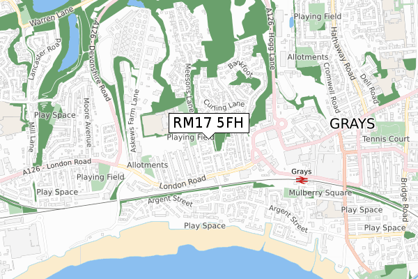
RM17 5FH is located in the Grays Riverside electoral ward, within the unitary authority of Thurrock and the English Parliamentary constituency of Thurrock. The Sub Integrated Care Board (ICB) Location is NHS Mid and South Essex ICB - 07G and the police force is Essex. This postcode has been in use since July 2018.


GetTheData
Source: OS Open Zoomstack (Ordnance Survey)
Licence: Open Government Licence (requires attribution)
Attribution: Contains OS data © Crown copyright and database right 2025
Source: Open Postcode Geo
Licence: Open Government Licence (requires attribution)
Attribution: Contains OS data © Crown copyright and database right 2025; Contains Royal Mail data © Royal Mail copyright and database right 2025; Source: Office for National Statistics licensed under the Open Government Licence v.3.0
| Easting | 560769 |
| Northing | 178067 |
| Latitude | 51.478718 |
| Longitude | 0.313762 |
GetTheData
Source: Open Postcode Geo
Licence: Open Government Licence
| Country | England |
| Postcode District | RM17 |
➜ See where RM17 is on a map ➜ Where is Grays? | |
GetTheData
Source: Land Registry Price Paid Data
Licence: Open Government Licence
| Ward | Grays Riverside |
| Constituency | Thurrock |
GetTheData
Source: ONS Postcode Database
Licence: Open Government Licence
2022 6 MAY £450,000 |
199, MALTHOUSE DRIVE, GRAYS, RM17 5FH 2019 30 APR £380,000 |
2019 29 MAR £375,000 |
255, MALTHOUSE DRIVE, GRAYS, RM17 5FH 2018 21 DEC £380,000 |
257, MALTHOUSE DRIVE, GRAYS, RM17 5FH 2018 21 DEC £370,000 |
145, MALTHOUSE DRIVE, GRAYS, RM17 5FH 2018 31 OCT £375,000 |
GetTheData
Source: HM Land Registry Price Paid Data
Licence: Contains HM Land Registry data © Crown copyright and database right 2025. This data is licensed under the Open Government Licence v3.0.
| Meesons Lane (London Road) | Grays | 224m |
| Aldi (London Road) | Grays | 240m |
| Meesons Lane (London Road) | Grays | 316m |
| Roseberry Road (London Road) | Grays | 354m |
| Roseberry Road (London Road) | Grays | 443m |
| Grays Station | 0.6km |
| Chafford Hundred Station | 2km |
| Swanscombe Station | 3.3km |
GetTheData
Source: NaPTAN
Licence: Open Government Licence
| Percentage of properties with Next Generation Access | 100.0% |
| Percentage of properties with Superfast Broadband | 100.0% |
| Percentage of properties with Ultrafast Broadband | 96.4% |
| Percentage of properties with Full Fibre Broadband | 96.4% |
Superfast Broadband is between 30Mbps and 300Mbps
Ultrafast Broadband is > 300Mbps
| Median download speed | 360.0Mbps |
| Average download speed | 360.0Mbps |
| Maximum download speed | 360.00Mbps |
| Median upload speed | 360.0Mbps |
| Average upload speed | 360.0Mbps |
| Maximum upload speed | 360.00Mbps |
| Percentage of properties unable to receive 2Mbps | 0.0% |
| Percentage of properties unable to receive 5Mbps | 0.0% |
| Percentage of properties unable to receive 10Mbps | 0.0% |
| Percentage of properties unable to receive 30Mbps | 0.0% |
GetTheData
Source: Ofcom
Licence: Ofcom Terms of Use (requires attribution)
GetTheData
Source: ONS Postcode Database
Licence: Open Government Licence


➜ Get more ratings from the Food Standards Agency
GetTheData
Source: Food Standards Agency
Licence: FSA terms & conditions
| Last Collection | |||
|---|---|---|---|
| Location | Mon-Fri | Sat | Distance |
| Bankfoot/Badgers Dean | 17:30 | 12:00 | 314m |
| Grays Delivery Office | 19:00 | 13:00 | 455m |
| Hove Close | 17:00 | 11:30 | 482m |
GetTheData
Source: Dracos
Licence: Creative Commons Attribution-ShareAlike
The below table lists the International Territorial Level (ITL) codes (formerly Nomenclature of Territorial Units for Statistics (NUTS) codes) and Local Administrative Units (LAU) codes for RM17 5FH:
| ITL 1 Code | Name |
|---|---|
| TLH | East |
| ITL 2 Code | Name |
| TLH3 | Essex |
| ITL 3 Code | Name |
| TLH32 | Thurrock |
| LAU 1 Code | Name |
| E06000034 | Thurrock |
GetTheData
Source: ONS Postcode Directory
Licence: Open Government Licence
The below table lists the Census Output Area (OA), Lower Layer Super Output Area (LSOA), and Middle Layer Super Output Area (MSOA) for RM17 5FH:
| Code | Name | |
|---|---|---|
| OA | E00080674 | |
| LSOA | E01015955 | Thurrock 016A |
| MSOA | E02003311 | Thurrock 016 |
GetTheData
Source: ONS Postcode Directory
Licence: Open Government Licence
| RM17 5JF | Kiln Way | 138m |
| RM17 5YN | Parker Road | 139m |
| RM17 5YW | Parker Road | 142m |
| RM17 5YQ | Grovelands Way | 172m |
| RM17 5JD | Helleborine | 175m |
| RM17 5JE | Kiln Way | 175m |
| RM17 5BF | Meesons Lane | 193m |
| RM17 5YG | Grovelands Way | 202m |
| RM17 5YJ | Belmont Road | 207m |
| RM17 5JB | Curling Lane | 227m |
GetTheData
Source: Open Postcode Geo; Land Registry Price Paid Data
Licence: Open Government Licence