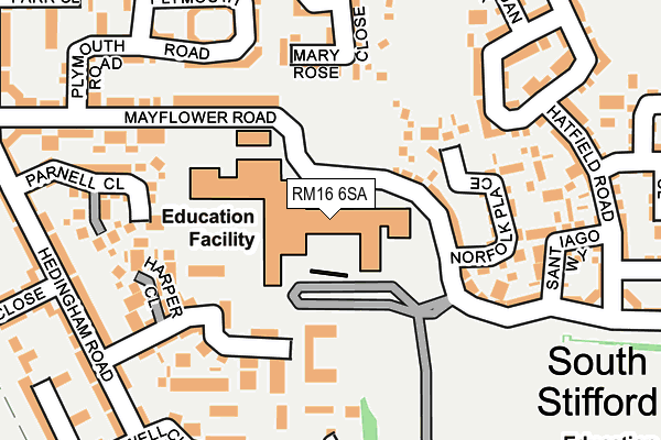
RM16 6SA is located in the South Chafford electoral ward, within the unitary authority of Thurrock and the English Parliamentary constituency of Thurrock. The Sub Integrated Care Board (ICB) Location is NHS Mid and South Essex ICB - 07G and the police force is Essex. This postcode has been in use since June 2002.


GetTheData
Source: OS OpenMap – Local (Ordnance Survey)
Source: OS VectorMap District (Ordnance Survey)
Licence: Open Government Licence (requires attribution)
| Easting | 559327 |
| Northing | 178383 |
| Latitude | 51.481964 |
| Longitude | 0.293129 |
GetTheData
Source: Open Postcode Geo
Licence: Open Government Licence
| Country | England |
| Postcode District | RM16 |
➜ See where RM16 is on a map ➜ Where is South Stifford? | |
GetTheData
Source: Land Registry Price Paid Data
Licence: Open Government Licence
Elevation or altitude of RM16 6SA as distance above sea level:
| Metres | Feet | |
|---|---|---|
| Elevation | 20m | 66ft |
Elevation is measured from the approximate centre of the postcode, to the nearest point on an OS contour line from OS Terrain 50, which has contour spacing of ten vertical metres.
➜ How high above sea level am I? Find the elevation of your current position using your device's GPS.
GetTheData
Source: Open Postcode Elevation
Licence: Open Government Licence
| Ward | South Chafford |
| Constituency | Thurrock |
GetTheData
Source: ONS Postcode Database
Licence: Open Government Licence
| Mayflower Road Library Campus (Mayflower Road) | Chafford Hundred | 142m |
| Mayflower Road Library Campus (Mayflower Road) | Chafford Hundred | 183m |
| Hatfield Road (Mayflower Road) | Chafford Hundred | 323m |
| Lancaster Road | Chafford Hundred | 360m |
| Saffron Road | Chafford Hundred | 433m |
| Chafford Hundred Station | 0.6km |
| Grays Station | 2.1km |
| Greenhithe for Bluewater Station | 3.6km |
GetTheData
Source: NaPTAN
Licence: Open Government Licence
GetTheData
Source: ONS Postcode Database
Licence: Open Government Licence


➜ Get more ratings from the Food Standards Agency
GetTheData
Source: Food Standards Agency
Licence: FSA terms & conditions
| Last Collection | |||
|---|---|---|---|
| Location | Mon-Fri | Sat | Distance |
| Drake Road | 18:30 | 12:00 | 1,252m |
| Tesco Lakeside | 18:30 | 11:30 | 1,437m |
| Purfleet Industrial Estate | 18:30 | 08:30 | 1,651m |
GetTheData
Source: Dracos
Licence: Creative Commons Attribution-ShareAlike
The below table lists the International Territorial Level (ITL) codes (formerly Nomenclature of Territorial Units for Statistics (NUTS) codes) and Local Administrative Units (LAU) codes for RM16 6SA:
| ITL 1 Code | Name |
|---|---|
| TLH | East |
| ITL 2 Code | Name |
| TLH3 | Essex |
| ITL 3 Code | Name |
| TLH32 | Thurrock |
| LAU 1 Code | Name |
| E06000034 | Thurrock |
GetTheData
Source: ONS Postcode Directory
Licence: Open Government Licence
The below table lists the Census Output Area (OA), Lower Layer Super Output Area (LSOA), and Middle Layer Super Output Area (MSOA) for RM16 6SA:
| Code | Name | |
|---|---|---|
| OA | E00175285 | |
| LSOA | E01033610 | Thurrock 019B |
| MSOA | E02006859 | Thurrock 019 |
GetTheData
Source: ONS Postcode Directory
Licence: Open Government Licence
| RM16 6BE | Mayflower Road | 82m |
| RM16 6DA | Harper Close | 129m |
| RM16 6DE | Norfolk Place | 157m |
| RM16 6LW | San Marcos Drive | 175m |
| RM16 6BF | Sewell Close | 193m |
| RM16 6BL | Plymouth Road | 194m |
| RM16 6LY | Mary Rose Close | 208m |
| RM16 6DF | Santiago Way | 216m |
| RM16 6BN | Plymouth Road | 218m |
| RM16 6BQ | Parnell Close | 231m |
GetTheData
Source: Open Postcode Geo; Land Registry Price Paid Data
Licence: Open Government Licence