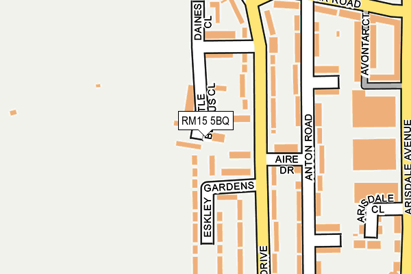
RM15 5BQ lies on Little Belhus Close in South Ockendon. RM15 5BQ is located in the Ockendon electoral ward, within the unitary authority of Thurrock and the English Parliamentary constituency of Thurrock. The Sub Integrated Care Board (ICB) Location is NHS Mid and South Essex ICB - 07G and the police force is Essex. This postcode has been in use since January 1980.


GetTheData
Source: OS OpenMap – Local (Ordnance Survey)
Source: OS VectorMap District (Ordnance Survey)
Licence: Open Government Licence (requires attribution)
| Easting | 558511 |
| Northing | 182152 |
| Latitude | 51.516056 |
| Longitude | 0.283108 |
GetTheData
Source: Open Postcode Geo
Licence: Open Government Licence
| Street | Little Belhus Close |
| Town/City | South Ockendon |
| Country | England |
| Postcode District | RM15 |
➜ See where RM15 is on a map ➜ Where is South Ockendon? | |
GetTheData
Source: Land Registry Price Paid Data
Licence: Open Government Licence
Elevation or altitude of RM15 5BQ as distance above sea level:
| Metres | Feet | |
|---|---|---|
| Elevation | 20m | 66ft |
Elevation is measured from the approximate centre of the postcode, to the nearest point on an OS contour line from OS Terrain 50, which has contour spacing of ten vertical metres.
➜ How high above sea level am I? Find the elevation of your current position using your device's GPS.
GetTheData
Source: Open Postcode Elevation
Licence: Open Government Licence
| Ward | Ockendon |
| Constituency | Thurrock |
GetTheData
Source: ONS Postcode Database
Licence: Open Government Licence
LITTLE BELHUS LODGE, LITTLE BELHUS CLOSE, SOUTH OCKENDON, RM15 5BQ 2003 18 JUL £199,950 |
LITTLE BELHUS LODGE, LITTLE BELHUS CLOSE, SOUTH OCKENDON, RM15 5BQ 1999 27 AUG £88,000 |
LITTLE BELHUS LODGE, LITTLE BELHUS CLOSE, SOUTH OCKENDON, RM15 5BQ 1997 5 DEC £76,500 |
LITTLE BELHUS LODGE, LITTLE BELHUS CLOSE, SOUTH OCKENDON, RM15 5BQ 1995 20 FEB £60,000 |
GetTheData
Source: HM Land Registry Price Paid Data
Licence: Contains HM Land Registry data © Crown copyright and database right 2025. This data is licensed under the Open Government Licence v3.0.
| Anton Road (Avontar Road) | South Ockendon | 258m |
| Erriff Drive (Daiglen Drive) | South Ockendon | 261m |
| Arcany Road (Arisdale Avenue) | South Ockendon | 292m |
| Arcany Road (Arisdale Avenue) | South Ockendon | 309m |
| Elan Road (Erriff Drive) | South Ockendon | 312m |
| Ockendon Station | 0.8km |
| Chafford Hundred Station | 3.4km |
| Purfleet Station | 5.1km |
GetTheData
Source: NaPTAN
Licence: Open Government Licence
| Percentage of properties with Next Generation Access | 100.0% |
| Percentage of properties with Superfast Broadband | 100.0% |
| Percentage of properties with Ultrafast Broadband | 100.0% |
| Percentage of properties with Full Fibre Broadband | 0.0% |
Superfast Broadband is between 30Mbps and 300Mbps
Ultrafast Broadband is > 300Mbps
| Percentage of properties unable to receive 2Mbps | 0.0% |
| Percentage of properties unable to receive 5Mbps | 0.0% |
| Percentage of properties unable to receive 10Mbps | 0.0% |
| Percentage of properties unable to receive 30Mbps | 0.0% |
GetTheData
Source: Ofcom
Licence: Ofcom Terms of Use (requires attribution)
GetTheData
Source: ONS Postcode Database
Licence: Open Government Licence


➜ Get more ratings from the Food Standards Agency
GetTheData
Source: Food Standards Agency
Licence: FSA terms & conditions
| Last Collection | |||
|---|---|---|---|
| Location | Mon-Fri | Sat | Distance |
| Arisdale Avenue | 17:15 | 12:15 | 302m |
| Eriff Drive | 17:30 | 11:30 | 651m |
| South Ockendon Post Office | 18:30 | 12:15 | 741m |
GetTheData
Source: Dracos
Licence: Creative Commons Attribution-ShareAlike
The below table lists the International Territorial Level (ITL) codes (formerly Nomenclature of Territorial Units for Statistics (NUTS) codes) and Local Administrative Units (LAU) codes for RM15 5BQ:
| ITL 1 Code | Name |
|---|---|
| TLH | East |
| ITL 2 Code | Name |
| TLH3 | Essex |
| ITL 3 Code | Name |
| TLH32 | Thurrock |
| LAU 1 Code | Name |
| E06000034 | Thurrock |
GetTheData
Source: ONS Postcode Directory
Licence: Open Government Licence
The below table lists the Census Output Area (OA), Lower Layer Super Output Area (LSOA), and Middle Layer Super Output Area (MSOA) for RM15 5BQ:
| Code | Name | |
|---|---|---|
| OA | E00080758 | |
| LSOA | E01015973 | Thurrock 006D |
| MSOA | E02003301 | Thurrock 006 |
GetTheData
Source: ONS Postcode Directory
Licence: Open Government Licence
| RM15 5BG | Little Belhus Close | 48m |
| RM15 5AH | Eskley Gardens | 57m |
| RM15 5AQ | Daiglen Drive | 61m |
| RM15 5AP | Aire Drive | 110m |
| RM15 5AD | Daiglen Drive | 116m |
| RM15 5AL | Daiglen Drive | 132m |
| RM15 5AR | Daiglen Drive | 160m |
| RM15 5AB | Eskley Gardens | 172m |
| RM15 5AU | Anton Road | 181m |
| RM15 5AT | Anton Road | 192m |
GetTheData
Source: Open Postcode Geo; Land Registry Price Paid Data
Licence: Open Government Licence