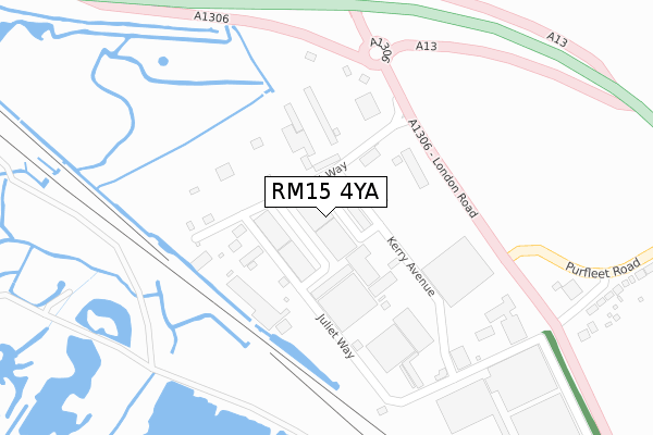
RM15 4YA lies on Thurrock Commercial Centre in Aveley, South Ockendon. RM15 4YA is located in the Aveley and Uplands electoral ward, within the unitary authority of Thurrock and the English Parliamentary constituency of Thurrock. The Sub Integrated Care Board (ICB) Location is NHS Mid and South Essex ICB - 07G and the police force is Essex. This postcode has been in use since October 1984.


GetTheData
Source: OS Open Zoomstack (Ordnance Survey)
Licence: Open Government Licence (requires attribution)
Attribution: Contains OS data © Crown copyright and database right 2025
Source: Open Postcode Geo
Licence: Open Government Licence (requires attribution)
Attribution: Contains OS data © Crown copyright and database right 2025; Contains Royal Mail data © Royal Mail copyright and database right 2025; Source: Office for National Statistics licensed under the Open Government Licence v.3.0
| Easting | 554786 |
| Northing | 179919 |
| Latitude | 51.497025 |
| Longitude | 0.228488 |
GetTheData
Source: Open Postcode Geo
Licence: Open Government Licence
| Street | Thurrock Commercial Centre |
| Locality | Aveley |
| Town/City | South Ockendon |
| Country | England |
| Postcode District | RM15 |
➜ See where RM15 is on a map ➜ Where is Aveley? | |
GetTheData
Source: Land Registry Price Paid Data
Licence: Open Government Licence
Elevation or altitude of RM15 4YA as distance above sea level:
| Metres | Feet | |
|---|---|---|
| Elevation | 10m | 33ft |
Elevation is measured from the approximate centre of the postcode, to the nearest point on an OS contour line from OS Terrain 50, which has contour spacing of ten vertical metres.
➜ How high above sea level am I? Find the elevation of your current position using your device's GPS.
GetTheData
Source: Open Postcode Elevation
Licence: Open Government Licence
| Ward | Aveley And Uplands |
| Constituency | Thurrock |
GetTheData
Source: ONS Postcode Database
Licence: Open Government Licence
| London Road (Purfleet Road) | Aveley | 522m |
| Purfleet Road | Aveley | 1,040m |
| Wennington Hall Farm | Wennington | 1,064m |
| Wennington Hall Farm | Wennington | 1,071m |
| Marlow Avenue (Tank Hill Road) | Purfleet | 1,122m |
| Purfleet Station | 1.9km |
| Rainham (London) Station | 3.4km |
| Erith Station | 4.1km |
GetTheData
Source: NaPTAN
Licence: Open Government Licence
| Median download speed | 17.3Mbps |
| Average download speed | 23.6Mbps |
| Maximum download speed | 80.00Mbps |
| Median upload speed | 1.1Mbps |
| Average upload speed | 3.4Mbps |
| Maximum upload speed | 20.00Mbps |
GetTheData
Source: Ofcom
Licence: Ofcom Terms of Use (requires attribution)
Estimated total energy consumption in RM15 4YA by fuel type, 2015.
| Consumption (kWh) | 139,064 |
|---|---|
| Meter count | 12 |
| Mean (kWh/meter) | 11,589 |
| Median (kWh/meter) | 11,313 |
GetTheData
Source: Postcode level gas estimates: 2015 (experimental)
Source: Postcode level electricity estimates: 2015 (experimental)
Licence: Open Government Licence
GetTheData
Source: ONS Postcode Database
Licence: Open Government Licence


➜ Get more ratings from the Food Standards Agency
GetTheData
Source: Food Standards Agency
Licence: FSA terms & conditions
| Last Collection | |||
|---|---|---|---|
| Location | Mon-Fri | Sat | Distance |
| Purfleet Road | 16:45 | 11:45 | 454m |
| Aveley Post Office | 17:15 | 11:45 | 1,060m |
| Hall Road | 16:45 | 11:45 | 1,628m |
GetTheData
Source: Dracos
Licence: Creative Commons Attribution-ShareAlike
| Risk of RM15 4YA flooding from rivers and sea | Very Low |
| ➜ RM15 4YA flood map | |
GetTheData
Source: Open Flood Risk by Postcode
Licence: Open Government Licence
The below table lists the International Territorial Level (ITL) codes (formerly Nomenclature of Territorial Units for Statistics (NUTS) codes) and Local Administrative Units (LAU) codes for RM15 4YA:
| ITL 1 Code | Name |
|---|---|
| TLH | East |
| ITL 2 Code | Name |
| TLH3 | Essex |
| ITL 3 Code | Name |
| TLH32 | Thurrock |
| LAU 1 Code | Name |
| E06000034 | Thurrock |
GetTheData
Source: ONS Postcode Directory
Licence: Open Government Licence
The below table lists the Census Output Area (OA), Lower Layer Super Output Area (LSOA), and Middle Layer Super Output Area (MSOA) for RM15 4YA:
| Code | Name | |
|---|---|---|
| OA | E00080521 | |
| LSOA | E01015925 | Thurrock 008D |
| MSOA | E02003303 | Thurrock 008 |
GetTheData
Source: ONS Postcode Directory
Licence: Open Government Licence
| RM15 4YG | Thurrock Commercial Centre | 14m |
| RM15 4YD | Juliette Way | 79m |
| RM15 4XT | London Road | 434m |
| RM15 4DT | Purfleet Road | 493m |
| RM15 4XU | London Road | 734m |
| RM15 4DX | Tunnel Cottages | 840m |
| RM15 4XP | Sandy Lane | 885m |
| RM15 4DS | Purfleet Road | 1031m |
| RM15 4EA | Purfleet Road | 1057m |
| RM19 1GX | Water Lane | 1082m |
GetTheData
Source: Open Postcode Geo; Land Registry Price Paid Data
Licence: Open Government Licence