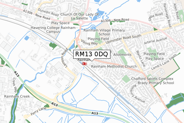
RM13 0DQ is located in the Rainham & Wennington electoral ward, within the London borough of Havering and the English Parliamentary constituency of Dagenham and Rainham. The Sub Integrated Care Board (ICB) Location is NHS North East London ICB - A3A8R and the police force is Metropolitan Police. This postcode has been in use since January 2020.


GetTheData
Source: OS Open Zoomstack (Ordnance Survey)
Licence: Open Government Licence (requires attribution)
Attribution: Contains OS data © Crown copyright and database right 2025
Source: Open Postcode Geo
Licence: Open Government Licence (requires attribution)
Attribution: Contains OS data © Crown copyright and database right 2025; Contains Royal Mail data © Royal Mail copyright and database right 2025; Source: Office for National Statistics licensed under the Open Government Licence v.3.0
| Easting | 552199 |
| Northing | 182059 |
| Latitude | 51.516955 |
| Longitude | 0.192173 |
GetTheData
Source: Open Postcode Geo
Licence: Open Government Licence
| Country | England |
| Postcode District | RM13 |
➜ See where RM13 is on a map | |
GetTheData
Source: Land Registry Price Paid Data
Licence: Open Government Licence
| Ward | Rainham & Wennington |
| Constituency | Dagenham And Rainham |
GetTheData
Source: ONS Postcode Database
Licence: Open Government Licence
| Rainham (Wennington Road) | Rainham | 24m |
| Rainham (Wennington Road) | Rainham | 47m |
| Rainham | Rainham | 68m |
| Rainham | Rainham | 98m |
| St Helen's Court | Rainham | 158m |
| Rainham (London) Station | 0.1km |
| Dagenham Dock Station | 3.4km |
| Belvedere Station | 3.9km |
GetTheData
Source: NaPTAN
Licence: Open Government Licence
GetTheData
Source: ONS Postcode Database
Licence: Open Government Licence


➜ Get more ratings from the Food Standards Agency
GetTheData
Source: Food Standards Agency
Licence: FSA terms & conditions
| Last Collection | |||
|---|---|---|---|
| Location | Mon-Fri | Sat | Distance |
| Wennington | 17:15 | 12:15 | 186m |
| Fairview Avenue Post Office | 18:30 | 12:00 | 1,375m |
| Anderson Way Meter Box | 3,134m | ||
GetTheData
Source: Dracos
Licence: Creative Commons Attribution-ShareAlike
| Risk of RM13 0DQ flooding from rivers and sea | Very Low |
| ➜ RM13 0DQ flood map | |
GetTheData
Source: Open Flood Risk by Postcode
Licence: Open Government Licence
The below table lists the International Territorial Level (ITL) codes (formerly Nomenclature of Territorial Units for Statistics (NUTS) codes) and Local Administrative Units (LAU) codes for RM13 0DQ:
| ITL 1 Code | Name |
|---|---|
| TLI | London |
| ITL 2 Code | Name |
| TLI5 | Outer London - East and North East |
| ITL 3 Code | Name |
| TLI52 | Barking & Dagenham and Havering |
| LAU 1 Code | Name |
| E09000016 | Havering |
GetTheData
Source: ONS Postcode Directory
Licence: Open Government Licence
The below table lists the Census Output Area (OA), Lower Layer Super Output Area (LSOA), and Middle Layer Super Output Area (MSOA) for RM13 0DQ:
| Code | Name | |
|---|---|---|
| OA | E00011726 | |
| LSOA | E01002345 | Havering 030B |
| MSOA | E02000493 | Havering 030 |
GetTheData
Source: ONS Postcode Directory
Licence: Open Government Licence
| RM13 9JA | Capstan Drive | 55m |
| RM13 9JF | Capstan Drive | 65m |
| RM13 9UH | Anglesey Drive | 70m |
| RM13 9JG | Capstan Drive | 82m |
| RM13 9YJ | Wennington Road | 95m |
| RM13 9JQ | Capstan Drive | 100m |
| RM13 9JW | Capstan Drive | 123m |
| RM13 9YU | Upminster Road South | 129m |
| RM13 9YN | Broadway | 130m |
| RM13 9UD | Ferro Road | 131m |
GetTheData
Source: Open Postcode Geo; Land Registry Price Paid Data
Licence: Open Government Licence