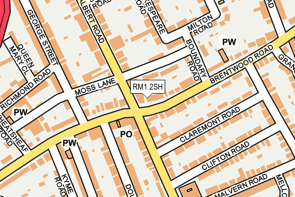
RM1 2SH is located in the St Alban's electoral ward, within the London borough of Havering and the English Parliamentary constituency of Romford. The Sub Integrated Care Board (ICB) Location is NHS North East London ICB - A3A8R and the police force is Metropolitan Police. This postcode has been in use since January 1980.


GetTheData
Source: OS OpenMap – Local (Ordnance Survey)
Source: OS VectorMap District (Ordnance Survey)
Licence: Open Government Licence (requires attribution)
| Easting | 551980 |
| Northing | 188227 |
| Latitude | 51.572431 |
| Longitude | 0.191652 |
GetTheData
Source: Open Postcode Geo
Licence: Open Government Licence
| Country | England |
| Postcode District | RM1 |
➜ See where RM1 is on a map ➜ Where is Romford? | |
GetTheData
Source: Land Registry Price Paid Data
Licence: Open Government Licence
Elevation or altitude of RM1 2SH as distance above sea level:
| Metres | Feet | |
|---|---|---|
| Elevation | 20m | 66ft |
Elevation is measured from the approximate centre of the postcode, to the nearest point on an OS contour line from OS Terrain 50, which has contour spacing of ten vertical metres.
➜ How high above sea level am I? Find the elevation of your current position using your device's GPS.
GetTheData
Source: Open Postcode Elevation
Licence: Open Government Licence
| Ward | St Alban's |
| Constituency | Romford |
GetTheData
Source: ONS Postcode Database
Licence: Open Government Licence
| Albert Road Romford | Heath Park | 47m |
| Albert Road Romford | Heath Park | 78m |
| Princes Road (Rm1) | Heath Park | 242m |
| Princes Road (Rm1) | Heath Park | 327m |
| South Street The Old Oak | Heath Park | 355m |
| Romford Station | 0.6km |
| Gidea Park Station | 1.4km |
| Emerson Park Station | 2km |
GetTheData
Source: NaPTAN
Licence: Open Government Licence
GetTheData
Source: ONS Postcode Database
Licence: Open Government Licence


➜ Get more ratings from the Food Standards Agency
GetTheData
Source: Food Standards Agency
Licence: FSA terms & conditions
| Last Collection | |||
|---|---|---|---|
| Location | Mon-Fri | Sat | Distance |
| Albany Road/Park Lane | 17:00 | 12:15 | 617m |
| Romford Station Business | 18:30 | 648m | |
| Romford Station | 18:30 | 12:00 | 652m |
GetTheData
Source: Dracos
Licence: Creative Commons Attribution-ShareAlike
The below table lists the International Territorial Level (ITL) codes (formerly Nomenclature of Territorial Units for Statistics (NUTS) codes) and Local Administrative Units (LAU) codes for RM1 2SH:
| ITL 1 Code | Name |
|---|---|
| TLI | London |
| ITL 2 Code | Name |
| TLI5 | Outer London - East and North East |
| ITL 3 Code | Name |
| TLI52 | Barking & Dagenham and Havering |
| LAU 1 Code | Name |
| E09000016 | Havering |
GetTheData
Source: ONS Postcode Directory
Licence: Open Government Licence
The below table lists the Census Output Area (OA), Lower Layer Super Output Area (LSOA), and Middle Layer Super Output Area (MSOA) for RM1 2SH:
| Code | Name | |
|---|---|---|
| OA | E00011730 | |
| LSOA | E01002358 | Havering 016E |
| MSOA | E02000479 | Havering 016 |
GetTheData
Source: ONS Postcode Directory
Licence: Open Government Licence
| RM1 2SA | Brentwood Road | 42m |
| RM1 2PR | Albert Road | 51m |
| RM1 2SB | Brentwood Road | 52m |
| RM1 2PT | Moss Lane | 58m |
| RM1 2EL | Brentwood Road | 66m |
| RM1 2EH | Brentwood Road | 94m |
| RM1 2RX | Brentwood Road | 106m |
| RM1 2PX | Boundary Road | 111m |
| RM11 1BB | Park Lane | 112m |
| RM1 2PS | Albert Road | 130m |
GetTheData
Source: Open Postcode Geo; Land Registry Price Paid Data
Licence: Open Government Licence