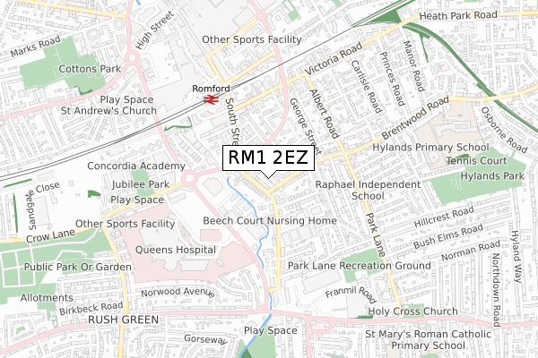
RM1 2EZ is located in the St Alban's electoral ward, within the London borough of Havering and the English Parliamentary constituency of Romford. The Sub Integrated Care Board (ICB) Location is NHS North East London ICB - A3A8R and the police force is Metropolitan Police. This postcode has been in use since September 2018.


GetTheData
Source: OS Open Zoomstack (Ordnance Survey)
Licence: Open Government Licence (requires attribution)
Attribution: Contains OS data © Crown copyright and database right 2025
Source: Open Postcode Geo
Licence: Open Government Licence (requires attribution)
Attribution: Contains OS data © Crown copyright and database right 2025; Contains Royal Mail data © Royal Mail copyright and database right 2025; Source: Office for National Statistics licensed under the Open Government Licence v.3.0
| Easting | 551606 |
| Northing | 188080 |
| Latitude | 51.571112 |
| Longitude | 0.186348 |
GetTheData
Source: Open Postcode Geo
Licence: Open Government Licence
| Country | England |
| Postcode District | RM1 |
➜ See where RM1 is on a map ➜ Where is Romford? | |
GetTheData
Source: Land Registry Price Paid Data
Licence: Open Government Licence
| Ward | St Alban's |
| Constituency | Romford |
GetTheData
Source: ONS Postcode Database
Licence: Open Government Licence
9, LENNOX CLOSE, ROMFORD, RM1 2EZ 2022 9 MAY £450,000 |
GetTheData
Source: HM Land Registry Price Paid Data
Licence: Contains HM Land Registry data © Crown copyright and database right 2025. This data is licensed under the Open Government Licence v3.0.
| South Street The Old Oak | Heath Park | 54m |
| Brentwood Road | Heath Park | 58m |
| South Street The Old Oak | Heath Park | 60m |
| Brentwood Road (South Street) | Heath Park | 99m |
| Thurloe Gardens | Heath Park | 102m |
| Romford Station | 0.5km |
| Gidea Park Station | 1.8km |
| Emerson Park Station | 2.4km |
GetTheData
Source: NaPTAN
Licence: Open Government Licence
| Percentage of properties with Next Generation Access | 100.0% |
| Percentage of properties with Superfast Broadband | 100.0% |
| Percentage of properties with Ultrafast Broadband | 0.0% |
| Percentage of properties with Full Fibre Broadband | 0.0% |
Superfast Broadband is between 30Mbps and 300Mbps
Ultrafast Broadband is > 300Mbps
| Percentage of properties unable to receive 2Mbps | 0.0% |
| Percentage of properties unable to receive 5Mbps | 0.0% |
| Percentage of properties unable to receive 10Mbps | 0.0% |
| Percentage of properties unable to receive 30Mbps | 0.0% |
GetTheData
Source: Ofcom
Licence: Ofcom Terms of Use (requires attribution)
GetTheData
Source: ONS Postcode Database
Licence: Open Government Licence


➜ Get more ratings from the Food Standards Agency
GetTheData
Source: Food Standards Agency
Licence: FSA terms & conditions
| Last Collection | |||
|---|---|---|---|
| Location | Mon-Fri | Sat | Distance |
| Romford Station Business | 18:30 | 476m | |
| Romford Station | 18:30 | 12:00 | 481m |
| Western Road | 18:30 | 12:00 | 647m |
GetTheData
Source: Dracos
Licence: Creative Commons Attribution-ShareAlike
The below table lists the International Territorial Level (ITL) codes (formerly Nomenclature of Territorial Units for Statistics (NUTS) codes) and Local Administrative Units (LAU) codes for RM1 2EZ:
| ITL 1 Code | Name |
|---|---|
| TLI | London |
| ITL 2 Code | Name |
| TLI5 | Outer London - East and North East |
| ITL 3 Code | Name |
| TLI52 | Barking & Dagenham and Havering |
| LAU 1 Code | Name |
| E09000016 | Havering |
GetTheData
Source: ONS Postcode Directory
Licence: Open Government Licence
The below table lists the Census Output Area (OA), Lower Layer Super Output Area (LSOA), and Middle Layer Super Output Area (MSOA) for RM1 2EZ:
| Code | Name | |
|---|---|---|
| OA | E00011772 | |
| LSOA | E01002350 | Havering 016B |
| MSOA | E02000479 | Havering 016 |
GetTheData
Source: ONS Postcode Directory
Licence: Open Government Licence
| RM1 2DZ | Lennox Close | 31m |
| RM1 2BE | South Street | 40m |
| RM1 2HA | Brentwood Road | 82m |
| RM1 2DY | Lennox Close | 87m |
| RM1 2AD | South Street | 98m |
| RM11 1AB | Artesian Close | 103m |
| RM1 2EX | Brentwood Road | 113m |
| RM1 2BH | South Street | 114m |
| RM1 2BS | Thurloe Gardens | 118m |
| RM1 2AW | South Street | 137m |
GetTheData
Source: Open Postcode Geo; Land Registry Price Paid Data
Licence: Open Government Licence