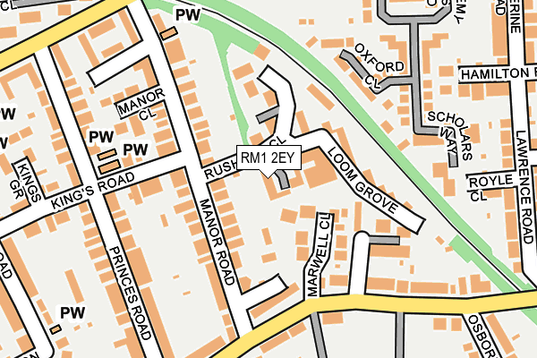
RM1 2EY is located in the St Alban's electoral ward, within the London borough of Havering and the English Parliamentary constituency of Romford. The Sub Integrated Care Board (ICB) Location is NHS North East London ICB - A3A8R and the police force is Metropolitan Police. This postcode has been in use since April 2017.


GetTheData
Source: OS OpenMap – Local (Ordnance Survey)
Source: OS VectorMap District (Ordnance Survey)
Licence: Open Government Licence (requires attribution)
| Easting | 552368 |
| Northing | 188591 |
| Latitude | 51.575599 |
| Longitude | 0.197430 |
GetTheData
Source: Open Postcode Geo
Licence: Open Government Licence
| Country | England |
| Postcode District | RM1 |
➜ See where RM1 is on a map ➜ Where is Romford? | |
GetTheData
Source: Land Registry Price Paid Data
Licence: Open Government Licence
| Ward | St Alban's |
| Constituency | Romford |
GetTheData
Source: ONS Postcode Database
Licence: Open Government Licence
| Frances Bardsley Academy | Heath Park | 217m |
| Frances Bardsley Academy | Heath Park | 226m |
| Princes Road (Rm1) | Heath Park | 242m |
| Fairholme Avenue | Heath Park | 251m |
| Manor Road Romford | Heath Park | 259m |
| Gidea Park Station | 0.9km |
| Romford Station | 1km |
| Emerson Park Station | 1.8km |
GetTheData
Source: NaPTAN
Licence: Open Government Licence
| Percentage of properties with Next Generation Access | 100.0% |
| Percentage of properties with Superfast Broadband | 100.0% |
| Percentage of properties with Ultrafast Broadband | 100.0% |
| Percentage of properties with Full Fibre Broadband | 0.0% |
Superfast Broadband is between 30Mbps and 300Mbps
Ultrafast Broadband is > 300Mbps
| Median download speed | 150.0Mbps |
| Average download speed | 141.7Mbps |
| Maximum download speed | 200.00Mbps |
Ofcom does not currently provide upload speed data for RM1 2EY. This is because there are less than four broadband connections in this postcode.
| Percentage of properties unable to receive 2Mbps | 0.0% |
| Percentage of properties unable to receive 5Mbps | 0.0% |
| Percentage of properties unable to receive 10Mbps | 0.0% |
| Percentage of properties unable to receive 30Mbps | 0.0% |
GetTheData
Source: Ofcom
Licence: Ofcom Terms of Use (requires attribution)
GetTheData
Source: ONS Postcode Database
Licence: Open Government Licence


➜ Get more ratings from the Food Standards Agency
GetTheData
Source: Food Standards Agency
Licence: FSA terms & conditions
| Last Collection | |||
|---|---|---|---|
| Location | Mon-Fri | Sat | Distance |
| Willow Street | 17:15 | 11:30 | 836m |
| Slewins Lane | 17:00 | 11:45 | 924m |
| Albany Road/Park Lane | 17:00 | 12:15 | 968m |
GetTheData
Source: Dracos
Licence: Creative Commons Attribution-ShareAlike
The below table lists the International Territorial Level (ITL) codes (formerly Nomenclature of Territorial Units for Statistics (NUTS) codes) and Local Administrative Units (LAU) codes for RM1 2EY:
| ITL 1 Code | Name |
|---|---|
| TLI | London |
| ITL 2 Code | Name |
| TLI5 | Outer London - East and North East |
| ITL 3 Code | Name |
| TLI52 | Barking & Dagenham and Havering |
| LAU 1 Code | Name |
| E09000016 | Havering |
GetTheData
Source: ONS Postcode Directory
Licence: Open Government Licence
The below table lists the Census Output Area (OA), Lower Layer Super Output Area (LSOA), and Middle Layer Super Output Area (MSOA) for RM1 2EY:
| Code | Name | |
|---|---|---|
| OA | E00011757 | |
| LSOA | E01002352 | Havering 016D |
| MSOA | E02000479 | Havering 016 |
GetTheData
Source: ONS Postcode Directory
Licence: Open Government Licence
| RM1 2TE | Marwell Close | 74m |
| RM1 2RD | Manor Road | 76m |
| RM1 2RE | Rushdon Close | 91m |
| RM1 2TH | Francombe Gardens | 96m |
| RM1 2SS | Kings Road | 137m |
| RM1 2TA | Manor Road | 138m |
| RM1 2RN | Rushdon Close | 142m |
| RM2 5UT | Oxford Close | 152m |
| RM1 2BW | Glades Close | 153m |
| RM1 2RP | Brentwood Road | 173m |
GetTheData
Source: Open Postcode Geo; Land Registry Price Paid Data
Licence: Open Government Licence