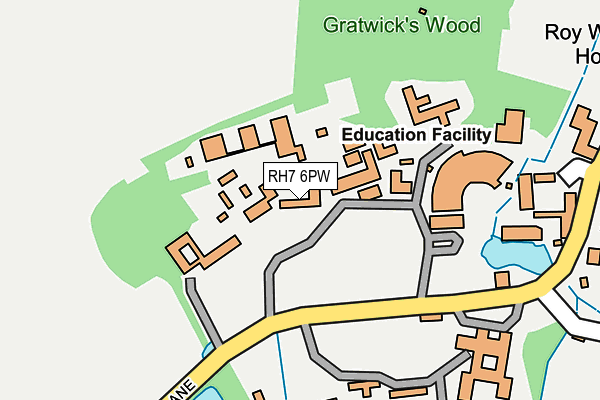
RH7 6PW is located in the Dormansland and Felcourt electoral ward, within the local authority district of Tandridge and the English Parliamentary constituency of East Surrey. The Sub Integrated Care Board (ICB) Location is NHS Surrey Heartlands ICB - 92A and the police force is Surrey. This postcode has been in use since January 1980.


GetTheData
Source: OS OpenMap – Local (Ordnance Survey)
Source: OS VectorMap District (Ordnance Survey)
Licence: Open Government Licence (requires attribution)
| Easting | 540265 |
| Northing | 143635 |
| Latitude | 51.174757 |
| Longitude | 0.005137 |
GetTheData
Source: Open Postcode Geo
Licence: Open Government Licence
| Country | England |
| Postcode District | RH7 |
➜ See where RH7 is on a map | |
GetTheData
Source: Land Registry Price Paid Data
Licence: Open Government Licence
Elevation or altitude of RH7 6PW as distance above sea level:
| Metres | Feet | |
|---|---|---|
| Elevation | 60m | 197ft |
Elevation is measured from the approximate centre of the postcode, to the nearest point on an OS contour line from OS Terrain 50, which has contour spacing of ten vertical metres.
➜ How high above sea level am I? Find the elevation of your current position using your device's GPS.
GetTheData
Source: Open Postcode Elevation
Licence: Open Government Licence
| Ward | Dormansland And Felcourt |
| Constituency | East Surrey |
GetTheData
Source: ONS Postcode Database
Licence: Open Government Licence
| St. Piers Lane (Racecourse Road) | Lingfield | 617m |
| St. Piers Lane (Racecourse Road) | Lingfield | 628m |
| Lingfield Racecourse (Racecourse Road) | Lingfield | 729m |
| Lingfield Racecourse (Racecourse Road) | Lingfield | 751m |
| The Plough (Plough Road) | Dormansland | 899m |
| Lingfield Station | 0.9km |
| Dormans Station | 2.2km |
| Edenbridge Town Station | 5.2km |
GetTheData
Source: NaPTAN
Licence: Open Government Licence
GetTheData
Source: ONS Postcode Database
Licence: Open Government Licence


➜ Get more ratings from the Food Standards Agency
GetTheData
Source: Food Standards Agency
Licence: FSA terms & conditions
| Last Collection | |||
|---|---|---|---|
| Location | Mon-Fri | Sat | Distance |
| Harrisons | 16:45 | 09:30 | 592m |
| Lingfield Station | 16:45 | 11:15 | 894m |
| Jeddere Cottages | 16:45 | 10:00 | 994m |
GetTheData
Source: Dracos
Licence: Creative Commons Attribution-ShareAlike
The below table lists the International Territorial Level (ITL) codes (formerly Nomenclature of Territorial Units for Statistics (NUTS) codes) and Local Administrative Units (LAU) codes for RH7 6PW:
| ITL 1 Code | Name |
|---|---|
| TLJ | South East (England) |
| ITL 2 Code | Name |
| TLJ2 | Surrey, East and West Sussex |
| ITL 3 Code | Name |
| TLJ26 | East Surrey |
| LAU 1 Code | Name |
| E07000215 | Tandridge |
GetTheData
Source: ONS Postcode Directory
Licence: Open Government Licence
The below table lists the Census Output Area (OA), Lower Layer Super Output Area (LSOA), and Middle Layer Super Output Area (MSOA) for RH7 6PW:
| Code | Name | |
|---|---|---|
| OA | E00157155 | |
| LSOA | E01030821 | Tandridge 010A |
| MSOA | E02006437 | Tandridge 010 |
GetTheData
Source: ONS Postcode Directory
Licence: Open Government Licence
| RH7 6PN | St Piers Lane | 313m |
| RH7 6PQ | Racecourse Road | 683m |
| RH7 6NX | Moor Lane | 818m |
| RH7 6PF | Racecourse Road | 824m |
| RH7 6GF | Tannery Gardens | 836m |
| RH7 6PP | Racecourse Road | 848m |
| RH7 6QH | Dormans Road | 870m |
| RH7 6EH | Eden Brook | 899m |
| RH7 6PR | Clayford | 921m |
| RH7 6HZ | Claridge Gardens | 940m |
GetTheData
Source: Open Postcode Geo; Land Registry Price Paid Data
Licence: Open Government Licence