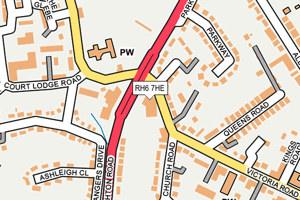
RH6 7HE is located in the Horley Central & South electoral ward, within the local authority district of Reigate and Banstead and the English Parliamentary constituency of East Surrey. The Sub Integrated Care Board (ICB) Location is NHS Surrey Heartlands ICB - 92A and the police force is Surrey. This postcode has been in use since January 1980.


GetTheData
Source: OS OpenMap – Local (Ordnance Survey)
Source: OS VectorMap District (Ordnance Survey)
Licence: Open Government Licence (requires attribution)
| Easting | 528039 |
| Northing | 143251 |
| Latitude | 51.174172 |
| Longitude | -0.169794 |
GetTheData
Source: Open Postcode Geo
Licence: Open Government Licence
| Country | England |
| Postcode District | RH6 |
➜ See where RH6 is on a map ➜ Where is Horley? | |
GetTheData
Source: Land Registry Price Paid Data
Licence: Open Government Licence
Elevation or altitude of RH6 7HE as distance above sea level:
| Metres | Feet | |
|---|---|---|
| Elevation | 60m | 197ft |
Elevation is measured from the approximate centre of the postcode, to the nearest point on an OS contour line from OS Terrain 50, which has contour spacing of ten vertical metres.
➜ How high above sea level am I? Find the elevation of your current position using your device's GPS.
GetTheData
Source: Open Postcode Elevation
Licence: Open Government Licence
| Ward | Horley Central & South |
| Constituency | East Surrey |
GetTheData
Source: ONS Postcode Database
Licence: Open Government Licence
| Air Balloon (Victoria Road) | Horley | 22m |
| Air Balloon (Victoria Road) | Horley | 40m |
| Park View (A23 Brighton Road) | Horley | 133m |
| Park View (A23 Brighton Road) | Horley | 140m |
| The Glebe (Vicarage Lane) | Horley | 175m |
| Gatwick North Terminal Shuttle Station (North Terminal) | Gatwick Airport | 1,535m |
| Horley Station | 0.9km |
| Gatwick Airport Station | 2.1km |
| Salfords (Surrey) Station | 3.1km |
GetTheData
Source: NaPTAN
Licence: Open Government Licence
GetTheData
Source: ONS Postcode Database
Licence: Open Government Licence


➜ Get more ratings from the Food Standards Agency
GetTheData
Source: Food Standards Agency
Licence: FSA terms & conditions
| Last Collection | |||
|---|---|---|---|
| Location | Mon-Fri | Sat | Distance |
| Air Balloon | 17:15 | 12:15 | 67m |
| Sangers Drive | 16:45 | 12:00 | 135m |
| Martins Newsagents | 18:30 | 12:30 | 431m |
GetTheData
Source: Dracos
Licence: Creative Commons Attribution-ShareAlike
The below table lists the International Territorial Level (ITL) codes (formerly Nomenclature of Territorial Units for Statistics (NUTS) codes) and Local Administrative Units (LAU) codes for RH6 7HE:
| ITL 1 Code | Name |
|---|---|
| TLJ | South East (England) |
| ITL 2 Code | Name |
| TLJ2 | Surrey, East and West Sussex |
| ITL 3 Code | Name |
| TLJ26 | East Surrey |
| LAU 1 Code | Name |
| E07000211 | Reigate and Banstead |
GetTheData
Source: ONS Postcode Directory
Licence: Open Government Licence
The below table lists the Census Output Area (OA), Lower Layer Super Output Area (LSOA), and Middle Layer Super Output Area (MSOA) for RH6 7HE:
| Code | Name | |
|---|---|---|
| OA | E00155959 | |
| LSOA | E01030575 | Reigate and Banstead 018A |
| MSOA | E02006392 | Reigate and Banstead 018 |
GetTheData
Source: ONS Postcode Directory
Licence: Open Government Licence
| RH6 7AW | Victoria Road | 53m |
| RH6 7BF | Victoria Road | 74m |
| RH6 7AP | Victoria Close | 94m |
| RH6 8AP | Vicarage Lane | 116m |
| RH6 7AJ | Queens Road | 138m |
| RH6 7HY | Parkway | 160m |
| RH6 7AT | The Orchard | 162m |
| RH6 7HD | Brighton Road | 170m |
| RH6 8AL | Sangers Drive | 171m |
| RH6 7BL | Victoria Road | 171m |
GetTheData
Source: Open Postcode Geo; Land Registry Price Paid Data
Licence: Open Government Licence