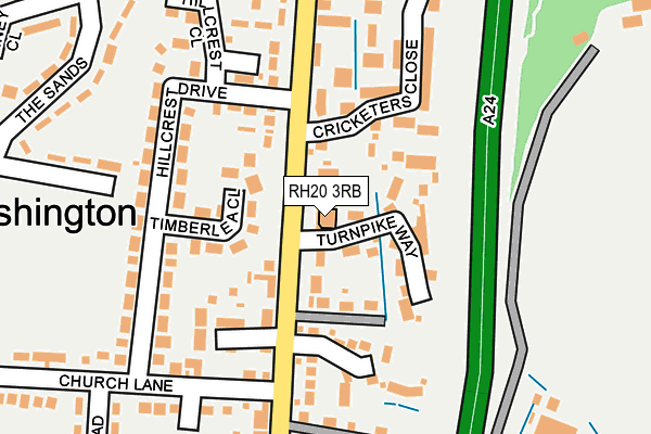
RH20 3RB is located in the West Chiltington, Thakeham & Ashington electoral ward, within the local authority district of Horsham and the English Parliamentary constituency of Arundel and South Downs. The Sub Integrated Care Board (ICB) Location is NHS Sussex ICB - 70F and the police force is Sussex. This postcode has been in use since June 2002.


GetTheData
Source: OS OpenMap – Local (Ordnance Survey)
Source: OS VectorMap District (Ordnance Survey)
Licence: Open Government Licence (requires attribution)
| Easting | 513257 |
| Northing | 116028 |
| Latitude | 50.932585 |
| Longitude | -0.389638 |
GetTheData
Source: Open Postcode Geo
Licence: Open Government Licence
| Country | England |
| Postcode District | RH20 |
➜ See where RH20 is on a map ➜ Where is Ashington? | |
GetTheData
Source: Land Registry Price Paid Data
Licence: Open Government Licence
Elevation or altitude of RH20 3RB as distance above sea level:
| Metres | Feet | |
|---|---|---|
| Elevation | 30m | 98ft |
Elevation is measured from the approximate centre of the postcode, to the nearest point on an OS contour line from OS Terrain 50, which has contour spacing of ten vertical metres.
➜ How high above sea level am I? Find the elevation of your current position using your device's GPS.
GetTheData
Source: Open Postcode Elevation
Licence: Open Government Licence
| Ward | West Chiltington, Thakeham & Ashington |
| Constituency | Arundel And South Downs |
GetTheData
Source: ONS Postcode Database
Licence: Open Government Licence
| Hillcrest Drive (London Road) | Ashington | 102m |
| Hillcrest Drive (London Road) | Ashington | 151m |
| The Sands | Ashington | 279m |
| Rectory Lane (London Road) | Ashington | 280m |
| Fairfield Road (Church Lane) | Ashington | 281m |
GetTheData
Source: NaPTAN
Licence: Open Government Licence
GetTheData
Source: ONS Postcode Database
Licence: Open Government Licence


➜ Get more ratings from the Food Standards Agency
GetTheData
Source: Food Standards Agency
Licence: FSA terms & conditions
| Last Collection | |||
|---|---|---|---|
| Location | Mon-Fri | Sat | Distance |
| Spear Hill | 16:15 | 10:00 | 1,241m |
| Goatchers Heath Common | 17:00 | 09:15 | 2,010m |
| Wiston Post Office | 17:00 | 08:00 | 2,320m |
GetTheData
Source: Dracos
Licence: Creative Commons Attribution-ShareAlike
The below table lists the International Territorial Level (ITL) codes (formerly Nomenclature of Territorial Units for Statistics (NUTS) codes) and Local Administrative Units (LAU) codes for RH20 3RB:
| ITL 1 Code | Name |
|---|---|
| TLJ | South East (England) |
| ITL 2 Code | Name |
| TLJ2 | Surrey, East and West Sussex |
| ITL 3 Code | Name |
| TLJ28 | West Sussex (North East) |
| LAU 1 Code | Name |
| E07000227 | Horsham |
GetTheData
Source: ONS Postcode Directory
Licence: Open Government Licence
The below table lists the Census Output Area (OA), Lower Layer Super Output Area (LSOA), and Middle Layer Super Output Area (MSOA) for RH20 3RB:
| Code | Name | |
|---|---|---|
| OA | E00161256 | |
| LSOA | E01031622 | Horsham 015A |
| MSOA | E02006602 | Horsham 015 |
GetTheData
Source: ONS Postcode Directory
Licence: Open Government Licence
| RH20 3JS | London Road | 61m |
| RH20 3QG | Turnpike Way | 68m |
| RH20 3LD | Timberlea Close | 99m |
| RH20 3JR | London Road | 117m |
| RH20 3LB | Hillcrest Drive | 136m |
| RH20 3JA | Ashdene Gardens | 137m |
| RH20 3QF | Posthorses | 143m |
| RH20 3JQ | Cricketers Close | 169m |
| RH20 3JU | Woelfs Close | 185m |
| RH20 3JY | Church Lane | 196m |
GetTheData
Source: Open Postcode Geo; Land Registry Price Paid Data
Licence: Open Government Licence