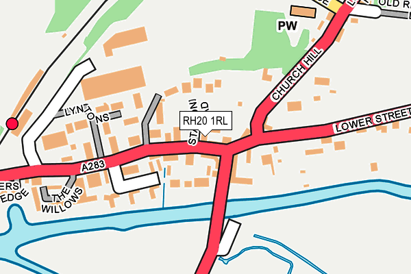
RH20 1RL lies on Swan Court in Pulborough. RH20 1RL is located in the Pulborough, Coldwaltham & Amberley electoral ward, within the local authority district of Horsham and the English Parliamentary constituency of Arundel and South Downs. The Sub Integrated Care Board (ICB) Location is NHS Sussex ICB - 70F and the police force is Sussex. This postcode has been in use since August 1992.


GetTheData
Source: OS OpenMap – Local (Ordnance Survey)
Source: OS VectorMap District (Ordnance Survey)
Licence: Open Government Licence (requires attribution)
| Easting | 504567 |
| Northing | 118591 |
| Latitude | 50.957263 |
| Longitude | -0.512521 |
GetTheData
Source: Open Postcode Geo
Licence: Open Government Licence
| Street | Swan Court |
| Town/City | Pulborough |
| Country | England |
| Postcode District | RH20 |
➜ See where RH20 is on a map ➜ Where is Pulborough? | |
GetTheData
Source: Land Registry Price Paid Data
Licence: Open Government Licence
Elevation or altitude of RH20 1RL as distance above sea level:
| Metres | Feet | |
|---|---|---|
| Elevation | 10m | 33ft |
Elevation is measured from the approximate centre of the postcode, to the nearest point on an OS contour line from OS Terrain 50, which has contour spacing of ten vertical metres.
➜ How high above sea level am I? Find the elevation of your current position using your device's GPS.
GetTheData
Source: Open Postcode Elevation
Licence: Open Government Licence
| Ward | Pulborough, Coldwaltham & Amberley |
| Constituency | Arundel And South Downs |
GetTheData
Source: ONS Postcode Database
Licence: Open Government Licence
UNIT 1, SWAN COURT, PULBOROUGH, RH20 1RL 2002 28 MAR £160,000 |
GetTheData
Source: HM Land Registry Price Paid Data
Licence: Contains HM Land Registry data © Crown copyright and database right 2024. This data is licensed under the Open Government Licence v3.0.
| Swan Bridge (London Road) | Pulborough | 67m |
| Swan Bridge (Stane Street) | Pulborough | 75m |
| Church Hill (Lower Street) | Pulborough | 116m |
| Church Hill (Lower Street) | Pulborough | 119m |
| Railway Station (Station Road) | Pulborough | 255m |
| Pulborough Station | 0.3km |
GetTheData
Source: NaPTAN
Licence: Open Government Licence
GetTheData
Source: ONS Postcode Database
Licence: Open Government Licence


➜ Get more ratings from the Food Standards Agency
GetTheData
Source: Food Standards Agency
Licence: FSA terms & conditions
| Last Collection | |||
|---|---|---|---|
| Location | Mon-Fri | Sat | Distance |
| Station Road | 17:15 | 10:30 | 72m |
| Church Hill | 17:00 | 10:30 | 250m |
| Pulborough Delivery Office | 17:45 | 11:45 | 690m |
GetTheData
Source: Dracos
Licence: Creative Commons Attribution-ShareAlike
The below table lists the International Territorial Level (ITL) codes (formerly Nomenclature of Territorial Units for Statistics (NUTS) codes) and Local Administrative Units (LAU) codes for RH20 1RL:
| ITL 1 Code | Name |
|---|---|
| TLJ | South East (England) |
| ITL 2 Code | Name |
| TLJ2 | Surrey, East and West Sussex |
| ITL 3 Code | Name |
| TLJ28 | West Sussex (North East) |
| LAU 1 Code | Name |
| E07000227 | Horsham |
GetTheData
Source: ONS Postcode Directory
Licence: Open Government Licence
The below table lists the Census Output Area (OA), Lower Layer Super Output Area (LSOA), and Middle Layer Super Output Area (MSOA) for RH20 1RL:
| Code | Name | |
|---|---|---|
| OA | E00161469 | |
| LSOA | E01031665 | Horsham 013F |
| MSOA | E02006600 | Horsham 013 |
GetTheData
Source: ONS Postcode Directory
Licence: Open Government Licence
| RH20 1AA | Church Hill | 54m |
| RH20 1RJ | Swan Corner | 73m |
| RH20 1AH | Station Road | 109m |
| RH20 1AU | Station Road | 137m |
| RH20 1AZ | Lyntons | 141m |
| RH20 1AL | Arun Prospect | 151m |
| RH20 1AJ | Cobbetts Mews | 181m |
| RH20 1SG | Station Villas | 197m |
| RH20 1RG | Station Road | 205m |
| RH20 2BH | Lower Street | 219m |
GetTheData
Source: Open Postcode Geo; Land Registry Price Paid Data
Licence: Open Government Licence