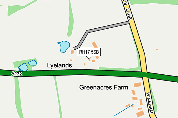
RH17 5SB is located in the Cuckfield, Bolney & Ansty electoral ward, within the local authority district of Mid Sussex and the English Parliamentary constituency of Mid Sussex. The Sub Integrated Care Board (ICB) Location is NHS Sussex ICB - 70F and the police force is Sussex. This postcode has been in use since January 1980.


GetTheData
Source: OS OpenMap – Local (Ordnance Survey)
Source: OS VectorMap District (Ordnance Survey)
Licence: Open Government Licence (requires attribution)
| Easting | 524069 |
| Northing | 122770 |
| Latitude | 50.990962 |
| Longitude | -0.233553 |
GetTheData
Source: Open Postcode Geo
Licence: Open Government Licence
| Country | England |
| Postcode District | RH17 |
➜ See where RH17 is on a map | |
GetTheData
Source: Land Registry Price Paid Data
Licence: Open Government Licence
Elevation or altitude of RH17 5SB as distance above sea level:
| Metres | Feet | |
|---|---|---|
| Elevation | 30m | 98ft |
Elevation is measured from the approximate centre of the postcode, to the nearest point on an OS contour line from OS Terrain 50, which has contour spacing of ten vertical metres.
➜ How high above sea level am I? Find the elevation of your current position using your device's GPS.
GetTheData
Source: Open Postcode Elevation
Licence: Open Government Licence
| Ward | Cuckfield, Bolney & Ansty |
| Constituency | Mid Sussex |
GetTheData
Source: ONS Postcode Database
Licence: Open Government Licence
| Spronketts Lane (A272) | Bolney | 154m |
| Spronketts Lane (A272) | Bolney | 198m |
| Homewood House (A272 Cowfold Road) | Bolney | 795m |
| Homewood House (A272 Cowfold Road) | Bolney | 798m |
| Southlands Farm (A272 Cowfold Road) | Cowfold | 824m |
GetTheData
Source: NaPTAN
Licence: Open Government Licence
GetTheData
Source: ONS Postcode Database
Licence: Open Government Licence


➜ Get more ratings from the Food Standards Agency
GetTheData
Source: Food Standards Agency
Licence: FSA terms & conditions
| Last Collection | |||
|---|---|---|---|
| Location | Mon-Fri | Sat | Distance |
| Twineham Green | 16:15 | 07:30 | 1,612m |
| Cowfold P O | 17:00 | 09:30 | 2,732m |
| Buncton Lane Bolney | 16:15 | 09:00 | 3,198m |
GetTheData
Source: Dracos
Licence: Creative Commons Attribution-ShareAlike
The below table lists the International Territorial Level (ITL) codes (formerly Nomenclature of Territorial Units for Statistics (NUTS) codes) and Local Administrative Units (LAU) codes for RH17 5SB:
| ITL 1 Code | Name |
|---|---|
| TLJ | South East (England) |
| ITL 2 Code | Name |
| TLJ2 | Surrey, East and West Sussex |
| ITL 3 Code | Name |
| TLJ28 | West Sussex (North East) |
| LAU 1 Code | Name |
| E07000228 | Mid Sussex |
GetTheData
Source: ONS Postcode Directory
Licence: Open Government Licence
The below table lists the Census Output Area (OA), Lower Layer Super Output Area (LSOA), and Middle Layer Super Output Area (MSOA) for RH17 5SB:
| Code | Name | |
|---|---|---|
| OA | E00161636 | |
| LSOA | E01031698 | Mid Sussex 016A |
| MSOA | E02006619 | Mid Sussex 016 |
GetTheData
Source: ONS Postcode Directory
Licence: Open Government Licence
| RH17 5SD | Wineham Lane | 777m |
| RH13 8AT | Picts Lane | 783m |
| RH13 8BA | Kent Street | 875m |
| RH17 5SE | Cowfold Road | 1104m |
| RH17 5SG | Cowfold Road | 1138m |
| RH17 5SA | Spronketts Lane | 1141m |
| RH13 8BB | Kent Street | 1218m |
| RH17 5RZ | Earwig Lane | 1413m |
| RH17 5RY | Cross Colwood Lane | 1441m |
| RH13 8AW | Picts Lane | 1442m |
GetTheData
Source: Open Postcode Geo; Land Registry Price Paid Data
Licence: Open Government Licence