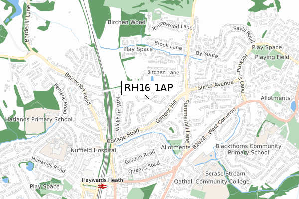
RH16 1AP is located in the Lindfield electoral ward, within the local authority district of Mid Sussex and the English Parliamentary constituency of Mid Sussex. The Sub Integrated Care Board (ICB) Location is NHS Sussex ICB - 70F and the police force is Sussex. This postcode has been in use since June 2019.


GetTheData
Source: OS Open Zoomstack (Ordnance Survey)
Licence: Open Government Licence (requires attribution)
Attribution: Contains OS data © Crown copyright and database right 2025
Source: Open Postcode Geo
Licence: Open Government Licence (requires attribution)
Attribution: Contains OS data © Crown copyright and database right 2025; Contains Royal Mail data © Royal Mail copyright and database right 2025; Source: Office for National Statistics licensed under the Open Government Licence v.3.0
| Easting | 533448 |
| Northing | 125358 |
| Latitude | 51.012125 |
| Longitude | -0.099043 |
GetTheData
Source: Open Postcode Geo
Licence: Open Government Licence
| Country | England |
| Postcode District | RH16 |
➜ See where RH16 is on a map | |
GetTheData
Source: Land Registry Price Paid Data
Licence: Open Government Licence
| Ward | Lindfield |
| Constituency | Mid Sussex |
GetTheData
Source: ONS Postcode Database
Licence: Open Government Licence
| Summerhill Close (Gander Hill) | Haywards Heath | 189m |
| Summerhill Close (Gander Hill) | Haywards Heath | 227m |
| Summerhill Lane | Haywards Heath | 324m |
| College Road | Haywards Heath | 333m |
| Sunte Avenue | Haywards Heath | 362m |
| Haywards Heath Station | 0.8km |
| Balcombe Station | 5.5km |
GetTheData
Source: NaPTAN
Licence: Open Government Licence
| Percentage of properties with Next Generation Access | 100.0% |
| Percentage of properties with Superfast Broadband | 100.0% |
| Percentage of properties with Ultrafast Broadband | 0.0% |
| Percentage of properties with Full Fibre Broadband | 0.0% |
Superfast Broadband is between 30Mbps and 300Mbps
Ultrafast Broadband is > 300Mbps
| Percentage of properties unable to receive 2Mbps | 0.0% |
| Percentage of properties unable to receive 5Mbps | 0.0% |
| Percentage of properties unable to receive 10Mbps | 0.0% |
| Percentage of properties unable to receive 30Mbps | 0.0% |
GetTheData
Source: Ofcom
Licence: Ofcom Terms of Use (requires attribution)
GetTheData
Source: ONS Postcode Database
Licence: Open Government Licence


➜ Get more ratings from the Food Standards Agency
GetTheData
Source: Food Standards Agency
Licence: FSA terms & conditions
| Last Collection | |||
|---|---|---|---|
| Location | Mon-Fri | Sat | Distance |
| Summerhill Lane | 17:15 | 12:00 | 339m |
| Sunte Avenue P O | 17:30 | 12:00 | 508m |
| Balcombe Road | 17:15 | 11:30 | 526m |
GetTheData
Source: Dracos
Licence: Creative Commons Attribution-ShareAlike
The below table lists the International Territorial Level (ITL) codes (formerly Nomenclature of Territorial Units for Statistics (NUTS) codes) and Local Administrative Units (LAU) codes for RH16 1AP:
| ITL 1 Code | Name |
|---|---|
| TLJ | South East (England) |
| ITL 2 Code | Name |
| TLJ2 | Surrey, East and West Sussex |
| ITL 3 Code | Name |
| TLJ28 | West Sussex (North East) |
| LAU 1 Code | Name |
| E07000228 | Mid Sussex |
GetTheData
Source: ONS Postcode Directory
Licence: Open Government Licence
The below table lists the Census Output Area (OA), Lower Layer Super Output Area (LSOA), and Middle Layer Super Output Area (MSOA) for RH16 1AP:
| Code | Name | |
|---|---|---|
| OA | E00161940 | |
| LSOA | E01031760 | Mid Sussex 008B |
| MSOA | E02006611 | Mid Sussex 008 |
GetTheData
Source: ONS Postcode Directory
Licence: Open Government Licence
| RH16 1RB | Gander Green | 123m |
| RH16 1QT | Sunte Close | 124m |
| RH16 1QU | Gander Hill | 158m |
| RH16 1QX | Gander Hill | 210m |
| RH16 1RE | Gander Hill | 219m |
| RH16 1UH | Wickham Close | 235m |
| RH16 1QS | College Road | 237m |
| RH16 1RY | Birchen Lane | 242m |
| RH16 1UJ | Wickham Way | 256m |
| RH16 1QR | College Road | 268m |
GetTheData
Source: Open Postcode Geo; Land Registry Price Paid Data
Licence: Open Government Licence