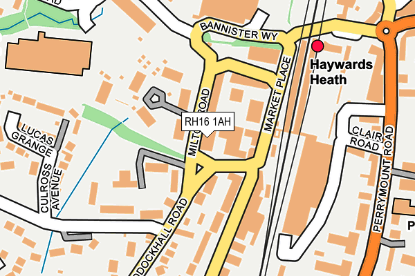
RH16 1AH is located in the Haywards Heath Lucastes & Bolnore electoral ward, within the local authority district of Mid Sussex and the English Parliamentary constituency of Mid Sussex. The Sub Integrated Care Board (ICB) Location is NHS Sussex ICB - 70F and the police force is Sussex. This postcode has been in use since March 2017.


GetTheData
Source: OS OpenMap – Local (Ordnance Survey)
Source: OS VectorMap District (Ordnance Survey)
Licence: Open Government Licence (requires attribution)
| Easting | 532896 |
| Northing | 124498 |
| Latitude | 51.004524 |
| Longitude | -0.107221 |
GetTheData
Source: Open Postcode Geo
Licence: Open Government Licence
| Country | England |
| Postcode District | RH16 |
➜ See where RH16 is on a map ➜ Where is Haywards Heath? | |
GetTheData
Source: Land Registry Price Paid Data
Licence: Open Government Licence
| Ward | Haywards Heath Lucastes & Bolnore |
| Constituency | Mid Sussex |
GetTheData
Source: ONS Postcode Database
Licence: Open Government Licence
| Market Square (Boltro Road) | Haywards Heath | 84m |
| Market Square (Market Place) | Haywards Heath | 103m |
| Sainsbury's (Bannister Way) | Haywards Heath | 166m |
| Railway Station (Market Place) | Haywards Heath | 223m |
| Burrell Road | Haywards Heath | 243m |
| Haywards Heath Station | 0.2km |
| Wivelsfield Station | 4.6km |
GetTheData
Source: NaPTAN
Licence: Open Government Licence
GetTheData
Source: ONS Postcode Database
Licence: Open Government Licence


➜ Get more ratings from the Food Standards Agency
GetTheData
Source: Food Standards Agency
Licence: FSA terms & conditions
| Last Collection | |||
|---|---|---|---|
| Location | Mon-Fri | Sat | Distance |
| Boltro Road | 18:15 | 12:15 | 210m |
| Haywards Heath Station | 229m | ||
| Sainsburys | 16:00 | 11:30 | 276m |
GetTheData
Source: Dracos
Licence: Creative Commons Attribution-ShareAlike
The below table lists the International Territorial Level (ITL) codes (formerly Nomenclature of Territorial Units for Statistics (NUTS) codes) and Local Administrative Units (LAU) codes for RH16 1AH:
| ITL 1 Code | Name |
|---|---|
| TLJ | South East (England) |
| ITL 2 Code | Name |
| TLJ2 | Surrey, East and West Sussex |
| ITL 3 Code | Name |
| TLJ28 | West Sussex (North East) |
| LAU 1 Code | Name |
| E07000228 | Mid Sussex |
GetTheData
Source: ONS Postcode Directory
Licence: Open Government Licence
The below table lists the Census Output Area (OA), Lower Layer Super Output Area (LSOA), and Middle Layer Super Output Area (MSOA) for RH16 1AH:
| Code | Name | |
|---|---|---|
| OA | E00161943 | |
| LSOA | E01031759 | Mid Sussex 009B |
| MSOA | E02006612 | Mid Sussex 009 |
GetTheData
Source: ONS Postcode Directory
Licence: Open Government Licence
| RH16 1FH | Great Heathmead | 43m |
| RH16 1FB | Great Heathmead | 64m |
| RH16 1EU | Paddockhall Road | 79m |
| RH16 1ET | Paddockhall Road | 86m |
| RH16 1FD | Great Heathmead | 94m |
| RH16 1BQ | Boltro Road | 95m |
| RH16 1FF | Great Heathmead | 102m |
| RH16 1LN | Harlands Road | 105m |
| RH16 1BP | Boltro Road | 126m |
| RH16 1FE | Great Heathmead | 129m |
GetTheData
Source: Open Postcode Geo; Land Registry Price Paid Data
Licence: Open Government Licence