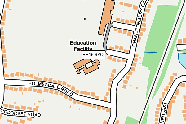
RH15 9YQ is located in the Burgess Hill Meeds & Hammonds electoral ward, within the local authority district of Mid Sussex and the English Parliamentary constituency of Mid Sussex. The Sub Integrated Care Board (ICB) Location is NHS Sussex ICB - 70F and the police force is Sussex. This postcode has been in use since October 1987.


GetTheData
Source: OS OpenMap – Local (Ordnance Survey)
Source: OS VectorMap District (Ordnance Survey)
Licence: Open Government Licence (requires attribution)
| Easting | 531230 |
| Northing | 118344 |
| Latitude | 50.949601 |
| Longitude | -0.133199 |
GetTheData
Source: Open Postcode Geo
Licence: Open Government Licence
| Country | England |
| Postcode District | RH15 |
➜ See where RH15 is on a map ➜ Where is Burgess Hill? | |
GetTheData
Source: Land Registry Price Paid Data
Licence: Open Government Licence
Elevation or altitude of RH15 9YQ as distance above sea level:
| Metres | Feet | |
|---|---|---|
| Elevation | 40m | 131ft |
Elevation is measured from the approximate centre of the postcode, to the nearest point on an OS contour line from OS Terrain 50, which has contour spacing of ten vertical metres.
➜ How high above sea level am I? Find the elevation of your current position using your device's GPS.
GetTheData
Source: Open Postcode Elevation
Licence: Open Government Licence
| Ward | Burgess Hill Meeds & Hammonds |
| Constituency | Mid Sussex |
GetTheData
Source: ONS Postcode Database
Licence: Open Government Licence
| Chanctonbury Road | Burgess Hill | 127m |
| Holmesdale Road (Chanctonbury Road) | Burgess Hill | 138m |
| Chanctonbury Road | Burgess Hill | 143m |
| Holmesdale Road (Chanctonbury Road) | Burgess Hill | 158m |
| Wingle Tye Road (Chanctonbury Road) | Burgess Hill | 301m |
| Burgess Hill Station | 0.6km |
| Wivelsfield Station | 1.9km |
| Hassocks Station | 2.9km |
GetTheData
Source: NaPTAN
Licence: Open Government Licence
GetTheData
Source: ONS Postcode Database
Licence: Open Government Licence


➜ Get more ratings from the Food Standards Agency
GetTheData
Source: Food Standards Agency
Licence: FSA terms & conditions
| Last Collection | |||
|---|---|---|---|
| Location | Mon-Fri | Sat | Distance |
| Holmesdale Road | 17:00 | 12:00 | 223m |
| Chanctonbury Road | 17:00 | 12:00 | 312m |
| Keymer Road | 17:00 | 11:00 | 556m |
GetTheData
Source: Dracos
Licence: Creative Commons Attribution-ShareAlike
The below table lists the International Territorial Level (ITL) codes (formerly Nomenclature of Territorial Units for Statistics (NUTS) codes) and Local Administrative Units (LAU) codes for RH15 9YQ:
| ITL 1 Code | Name |
|---|---|
| TLJ | South East (England) |
| ITL 2 Code | Name |
| TLJ2 | Surrey, East and West Sussex |
| ITL 3 Code | Name |
| TLJ28 | West Sussex (North East) |
| LAU 1 Code | Name |
| E07000228 | Mid Sussex |
GetTheData
Source: ONS Postcode Directory
Licence: Open Government Licence
The below table lists the Census Output Area (OA), Lower Layer Super Output Area (LSOA), and Middle Layer Super Output Area (MSOA) for RH15 9YQ:
| Code | Name | |
|---|---|---|
| OA | E00161686 | |
| LSOA | E01031710 | Mid Sussex 015C |
| MSOA | E02006618 | Mid Sussex 015 |
GetTheData
Source: ONS Postcode Directory
Licence: Open Government Licence
| RH15 9HA | Chanctonbury Road | 74m |
| RH15 9EZ | Chanctonbury Road | 124m |
| RH15 9JR | Holmesdale Road | 140m |
| RH15 9JP | Holmesdale Road | 152m |
| RH15 9HB | Priory Road | 247m |
| RH15 0DQ | Pinehurst | 258m |
| RH15 9EY | Chanctonbury Road | 259m |
| RH15 9HD | Priory Road | 263m |
| RH15 9HE | Chanctonbury Road | 272m |
| RH15 9EX | Chanctonbury Road | 282m |
GetTheData
Source: Open Postcode Geo; Land Registry Price Paid Data
Licence: Open Government Licence