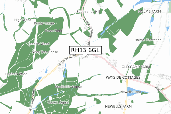
RH13 6GL is located in the Nuthurst & Lower Beeding electoral ward, within the local authority district of Horsham and the English Parliamentary constituency of Horsham. The Sub Integrated Care Board (ICB) Location is NHS Sussex ICB - 70F and the police force is Sussex. This postcode has been in use since June 2019.


GetTheData
Source: OS Open Zoomstack (Ordnance Survey)
Licence: Open Government Licence (requires attribution)
Attribution: Contains OS data © Crown copyright and database right 2025
Source: Open Postcode Geo
Licence: Open Government Licence (requires attribution)
Attribution: Contains OS data © Crown copyright and database right 2025; Contains Royal Mail data © Royal Mail copyright and database right 2025; Source: Office for National Statistics licensed under the Open Government Licence v.3.0
| Easting | 520237 |
| Northing | 127503 |
| Latitude | 51.034316 |
| Longitude | -0.286560 |
GetTheData
Source: Open Postcode Geo
Licence: Open Government Licence
| Country | England |
| Postcode District | RH13 |
➜ See where RH13 is on a map | |
GetTheData
Source: Land Registry Price Paid Data
Licence: Open Government Licence
| Ward | Nuthurst & Lower Beeding |
| Constituency | Horsham |
GetTheData
Source: ONS Postcode Database
Licence: Open Government Licence
| Fieldgate Close (Nuthurst Road) | Monk's Gate | 77m |
| Fieldgate Close (Nuthurst Road) | Monk's Gate | 79m |
| Nuthurst Road (Brighton Road) | Monk's Gate | 163m |
| Nuthurst Road (Brighton Road) | Monk's Gate | 184m |
| Saxtons Farm (Nuthurst Road) | Monk's Gate | 385m |
| Horsham Station | 4.2km |
GetTheData
Source: NaPTAN
Licence: Open Government Licence
| Percentage of properties with Next Generation Access | 100.0% |
| Percentage of properties with Superfast Broadband | 100.0% |
| Percentage of properties with Ultrafast Broadband | 0.0% |
| Percentage of properties with Full Fibre Broadband | 0.0% |
Superfast Broadband is between 30Mbps and 300Mbps
Ultrafast Broadband is > 300Mbps
| Percentage of properties unable to receive 2Mbps | 0.0% |
| Percentage of properties unable to receive 5Mbps | 0.0% |
| Percentage of properties unable to receive 10Mbps | 0.0% |
| Percentage of properties unable to receive 30Mbps | 0.0% |
GetTheData
Source: Ofcom
Licence: Ofcom Terms of Use (requires attribution)
GetTheData
Source: ONS Postcode Database
Licence: Open Government Licence


➜ Get more ratings from the Food Standards Agency
GetTheData
Source: Food Standards Agency
Licence: FSA terms & conditions
| Last Collection | |||
|---|---|---|---|
| Location | Mon-Fri | Sat | Distance |
| Mannings Heath | 16:45 | 09:45 | 1,212m |
| St Leonards Road | 17:15 | 12:00 | 3,203m |
| Highlands Road | 17:15 | 12:00 | 3,203m |
GetTheData
Source: Dracos
Licence: Creative Commons Attribution-ShareAlike
The below table lists the International Territorial Level (ITL) codes (formerly Nomenclature of Territorial Units for Statistics (NUTS) codes) and Local Administrative Units (LAU) codes for RH13 6GL:
| ITL 1 Code | Name |
|---|---|
| TLJ | South East (England) |
| ITL 2 Code | Name |
| TLJ2 | Surrey, East and West Sussex |
| ITL 3 Code | Name |
| TLJ28 | West Sussex (North East) |
| LAU 1 Code | Name |
| E07000227 | Horsham |
GetTheData
Source: ONS Postcode Directory
Licence: Open Government Licence
The below table lists the Census Output Area (OA), Lower Layer Super Output Area (LSOA), and Middle Layer Super Output Area (MSOA) for RH13 6GL:
| Code | Name | |
|---|---|---|
| OA | E00161458 | |
| LSOA | E01031660 | Horsham 008C |
| MSOA | E02006595 | Horsham 008 |
GetTheData
Source: ONS Postcode Directory
Licence: Open Government Licence
| RH13 6RS | Fieldgate Close | 142m |
| RH13 6LG | Nuthurst Road | 165m |
| RH13 6JB | Brighton Road | 232m |
| RH13 6JD | Brighton Road | 360m |
| RH13 6JA | Brighton Road | 565m |
| RH13 6JF | Swallowfield Close | 949m |
| RH13 6JG | Woodlands Walk | 990m |
| RH13 6JE | Church Road | 1042m |
| RH13 6HZ | Brighton Road | 1055m |
| RH13 6JQ | Forest Close | 1062m |
GetTheData
Source: Open Postcode Geo; Land Registry Price Paid Data
Licence: Open Government Licence