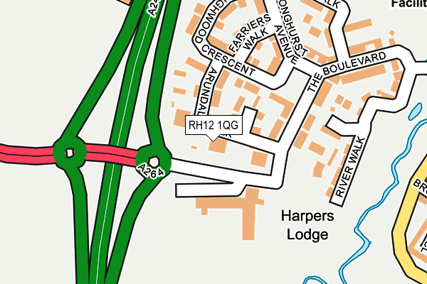
RH12 1QG is located in the Denne electoral ward, within the local authority district of Horsham and the English Parliamentary constituency of Horsham. The Sub Integrated Care Board (ICB) Location is NHS Sussex ICB - 70F and the police force is Sussex. This postcode has been in use since May 2017.


GetTheData
Source: OS OpenMap – Local (Ordnance Survey)
Source: OS VectorMap District (Ordnance Survey)
Licence: Open Government Licence (requires attribution)
| Easting | 515312 |
| Northing | 130437 |
| Latitude | 51.061696 |
| Longitude | -0.355835 |
GetTheData
Source: Open Postcode Geo
Licence: Open Government Licence
| Country | England |
| Postcode District | RH12 |
➜ See where RH12 is on a map ➜ Where is Horsham? | |
GetTheData
Source: Land Registry Price Paid Data
Licence: Open Government Licence
| Ward | Denne |
| Constituency | Horsham |
GetTheData
Source: ONS Postcode Database
Licence: Open Government Licence
| Stoneybrook (Hills Farm Lane) | Horsham | 329m |
| Relief Road (Broadbridge Heath Relief Road) | Wickhurst Green | 334m |
| Stoneybrook (Hills Farm Lane) | Horsham | 366m |
| Tesco (Wickhurst Lane) | Broadbridge Heath | 472m |
| Fellcott Way (Hills Farm Lane) | Horsham | 486m |
| Christs Hospital Station | 1.3km |
| Horsham Station | 2.6km |
| Littlehaven Station | 3.9km |
GetTheData
Source: NaPTAN
Licence: Open Government Licence
| Percentage of properties with Next Generation Access | 100.0% |
| Percentage of properties with Superfast Broadband | 100.0% |
| Percentage of properties with Ultrafast Broadband | 100.0% |
| Percentage of properties with Full Fibre Broadband | 100.0% |
Superfast Broadband is between 30Mbps and 300Mbps
Ultrafast Broadband is > 300Mbps
| Median download speed | 5.2Mbps |
| Average download speed | 5.0Mbps |
| Maximum download speed | 6.67Mbps |
| Median upload speed | 0.8Mbps |
| Average upload speed | 0.7Mbps |
| Maximum upload speed | 0.98Mbps |
| Percentage of properties unable to receive 2Mbps | 0.0% |
| Percentage of properties unable to receive 5Mbps | 0.0% |
| Percentage of properties unable to receive 10Mbps | 0.0% |
| Percentage of properties unable to receive 30Mbps | 0.0% |
GetTheData
Source: Ofcom
Licence: Ofcom Terms of Use (requires attribution)
GetTheData
Source: ONS Postcode Database
Licence: Open Government Licence


➜ Get more ratings from the Food Standards Agency
GetTheData
Source: Food Standards Agency
Licence: FSA terms & conditions
| Last Collection | |||
|---|---|---|---|
| Location | Mon-Fri | Sat | Distance |
| Groombridge Way | 17:00 | 12:00 | 484m |
| Granary Way | 17:00 | 12:00 | 828m |
| Wickhurst Lane | 16:45 | 08:30 | 870m |
GetTheData
Source: Dracos
Licence: Creative Commons Attribution-ShareAlike
The below table lists the International Territorial Level (ITL) codes (formerly Nomenclature of Territorial Units for Statistics (NUTS) codes) and Local Administrative Units (LAU) codes for RH12 1QG:
| ITL 1 Code | Name |
|---|---|
| TLJ | South East (England) |
| ITL 2 Code | Name |
| TLJ2 | Surrey, East and West Sussex |
| ITL 3 Code | Name |
| TLJ28 | West Sussex (North East) |
| LAU 1 Code | Name |
| E07000227 | Horsham |
GetTheData
Source: ONS Postcode Directory
Licence: Open Government Licence
The below table lists the Census Output Area (OA), Lower Layer Super Output Area (LSOA), and Middle Layer Super Output Area (MSOA) for RH12 1QG:
| Code | Name | |
|---|---|---|
| OA | E00167712 | |
| LSOA | E01031637 | Horsham 007B |
| MSOA | E02006594 | Horsham 007 |
GetTheData
Source: ONS Postcode Directory
Licence: Open Government Licence
| RH12 1GF | The Boulevard | 98m |
| RH12 1EW | Eaton Place | 116m |
| RH12 1EP | The Boulevard | 117m |
| RH12 1EN | Highwood Crescent | 134m |
| RH12 1DS | Farriers Walk | 169m |
| RH12 1DU | River Walk | 184m |
| RH12 1UG | Highwood Crescent | 205m |
| RH12 1QH | Scholars Walk | 237m |
| RH12 1BH | Longhurst Avenue | 239m |
| RH12 1AD | Scholars Walk | 267m |
GetTheData
Source: Open Postcode Geo; Land Registry Price Paid Data
Licence: Open Government Licence