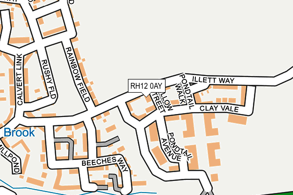
RH12 0AY is located in the Colgate & Rusper electoral ward, within the local authority district of Horsham and the English Parliamentary constituency of Horsham. The Sub Integrated Care Board (ICB) Location is NHS Sussex ICB - 70F and the police force is Sussex. This postcode has been in use since March 2017.


GetTheData
Source: OS OpenMap – Local (Ordnance Survey)
Source: OS VectorMap District (Ordnance Survey)
Licence: Open Government Licence (requires attribution)
| Easting | 523418 |
| Northing | 134817 |
| Latitude | 51.099379 |
| Longitude | -0.238722 |
GetTheData
Source: Open Postcode Geo
Licence: Open Government Licence
| Country | England |
| Postcode District | RH12 |
➜ See where RH12 is on a map ➜ Where is Crawley? | |
GetTheData
Source: Land Registry Price Paid Data
Licence: Open Government Licence
| Ward | Colgate & Rusper |
| Constituency | Horsham |
GetTheData
Source: ONS Postcode Database
Licence: Open Government Licence
2, WILLOW STREET, FAYGATE, HORSHAM, RH12 0AY 2017 28 APR £339,950 |
GetTheData
Source: HM Land Registry Price Paid Data
Licence: Contains HM Land Registry data © Crown copyright and database right 2024. This data is licensed under the Open Government Licence v3.0.
| Kilnwood Vale (Calvert Link) | Faygate | 336m |
| Holmbush Farm (Crawley Road) | Faygate | 613m |
| Francis Edwards Way (Sullivan Drive) | Bewbush | 651m |
| Redditch Close (Sullivan Drive) | Bewbush | 698m |
| Warrington Close (Sullivan Drive) | Bewbush | 741m |
| Faygate Station | 1.7km |
| Ifield Station | 2.5km |
| Crawley Station | 3.9km |
GetTheData
Source: NaPTAN
Licence: Open Government Licence
| Percentage of properties with Next Generation Access | 100.0% |
| Percentage of properties with Superfast Broadband | 85.7% |
| Percentage of properties with Ultrafast Broadband | 85.7% |
| Percentage of properties with Full Fibre Broadband | 85.7% |
Superfast Broadband is between 30Mbps and 300Mbps
Ultrafast Broadband is > 300Mbps
| Percentage of properties unable to receive 2Mbps | 0.0% |
| Percentage of properties unable to receive 5Mbps | 0.0% |
| Percentage of properties unable to receive 10Mbps | 0.0% |
| Percentage of properties unable to receive 30Mbps | 14.3% |
GetTheData
Source: Ofcom
Licence: Ofcom Terms of Use (requires attribution)
GetTheData
Source: ONS Postcode Database
Licence: Open Government Licence


➜ Get more ratings from the Food Standards Agency
GetTheData
Source: Food Standards Agency
Licence: FSA terms & conditions
| Last Collection | |||
|---|---|---|---|
| Location | Mon-Fri | Sat | Distance |
| Basildon Way | 17:30 | 11:30 | 903m |
| Stoneycroft Walk | 17:30 | 11:45 | 1,175m |
| Waterfield Gardens | 17:30 | 11:15 | 1,246m |
GetTheData
Source: Dracos
Licence: Creative Commons Attribution-ShareAlike
The below table lists the International Territorial Level (ITL) codes (formerly Nomenclature of Territorial Units for Statistics (NUTS) codes) and Local Administrative Units (LAU) codes for RH12 0AY:
| ITL 1 Code | Name |
|---|---|
| TLJ | South East (England) |
| ITL 2 Code | Name |
| TLJ2 | Surrey, East and West Sussex |
| ITL 3 Code | Name |
| TLJ28 | West Sussex (North East) |
| LAU 1 Code | Name |
| E07000227 | Horsham |
GetTheData
Source: ONS Postcode Directory
Licence: Open Government Licence
The below table lists the Census Output Area (OA), Lower Layer Super Output Area (LSOA), and Middle Layer Super Output Area (MSOA) for RH12 0AY:
| Code | Name | |
|---|---|---|
| OA | E00161531 | |
| LSOA | E01031676 | Horsham 001D |
| MSOA | E02006588 | Horsham 001 |
GetTheData
Source: ONS Postcode Directory
Licence: Open Government Licence
| RH12 0AJ | Illett Way | 44m |
| RH12 0AD | Beeches Way | 186m |
| RH12 0AG | Calvert Link | 189m |
| RH12 0AB | Beeches Way | 192m |
| RH12 0AS | Rushy Field | 204m |
| RH12 0AF | Calvert Link | 280m |
| RH12 0AQ | Millpond Lane | 295m |
| RH12 0AE | Brickyard Way | 296m |
| RH12 0AN | Kilnwood Close | 296m |
| RH12 0AP | Kilnwood Close | 296m |
GetTheData
Source: Open Postcode Geo; Land Registry Price Paid Data
Licence: Open Government Licence