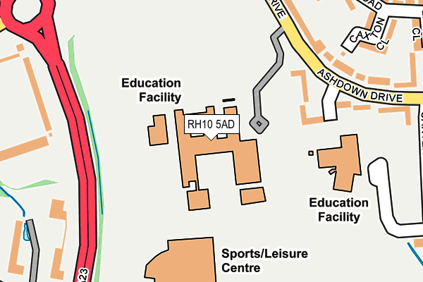
RH10 5AD is located in the Tilgate electoral ward, within the local authority district of Crawley and the English Parliamentary constituency of Crawley. The Sub Integrated Care Board (ICB) Location is NHS Sussex ICB - 70F and the police force is Sussex. This postcode has been in use since January 1980.


GetTheData
Source: OS OpenMap – Local (Ordnance Survey)
Source: OS VectorMap District (Ordnance Survey)
Licence: Open Government Licence (requires attribution)
| Easting | 526785 |
| Northing | 134874 |
| Latitude | 51.099162 |
| Longitude | -0.190668 |
GetTheData
Source: Open Postcode Geo
Licence: Open Government Licence
| Country | England |
| Postcode District | RH10 |
➜ See where RH10 is on a map ➜ Where is Crawley? | |
GetTheData
Source: Land Registry Price Paid Data
Licence: Open Government Licence
Elevation or altitude of RH10 5AD as distance above sea level:
| Metres | Feet | |
|---|---|---|
| Elevation | 80m | 262ft |
Elevation is measured from the approximate centre of the postcode, to the nearest point on an OS contour line from OS Terrain 50, which has contour spacing of ten vertical metres.
➜ How high above sea level am I? Find the elevation of your current position using your device's GPS.
GetTheData
Source: Open Postcode Elevation
Licence: Open Government Licence
| Ward | Tilgate |
| Constituency | Crawley |
GetTheData
Source: ONS Postcode Database
Licence: Open Government Licence
| K2 Leisure Centre | Tilgate | 191m |
| Broadfield Park (A23) | Broadfield | 263m |
| Thomas Bennett School (Ashdown Drive) | Tilgate | 291m |
| Thomas Bennett School (Ashdown Drive) | Tilgate | 292m |
| Southgate Avenue South (Southgate Avenue) | Tilgate | 300m |
| Crawley Station | 1.5km |
| Ifield Station | 2.5km |
| Three Bridges Station | 2.9km |
GetTheData
Source: NaPTAN
Licence: Open Government Licence
GetTheData
Source: ONS Postcode Database
Licence: Open Government Licence


➜ Get more ratings from the Food Standards Agency
GetTheData
Source: Food Standards Agency
Licence: FSA terms & conditions
| Last Collection | |||
|---|---|---|---|
| Location | Mon-Fri | Sat | Distance |
| Ashdown Drive | 17:30 | 11:00 | 227m |
| Winchester Road | 17:30 | 11:15 | 431m |
| Wakehurst Drive | 17:30 | 11:45 | 471m |
GetTheData
Source: Dracos
Licence: Creative Commons Attribution-ShareAlike
| Risk of RH10 5AD flooding from rivers and sea | Medium |
| ➜ RH10 5AD flood map | |
GetTheData
Source: Open Flood Risk by Postcode
Licence: Open Government Licence
The below table lists the International Territorial Level (ITL) codes (formerly Nomenclature of Territorial Units for Statistics (NUTS) codes) and Local Administrative Units (LAU) codes for RH10 5AD:
| ITL 1 Code | Name |
|---|---|
| TLJ | South East (England) |
| ITL 2 Code | Name |
| TLJ2 | Surrey, East and West Sussex |
| ITL 3 Code | Name |
| TLJ28 | West Sussex (North East) |
| LAU 1 Code | Name |
| E07000226 | Crawley |
GetTheData
Source: ONS Postcode Directory
Licence: Open Government Licence
The below table lists the Census Output Area (OA), Lower Layer Super Output Area (LSOA), and Middle Layer Super Output Area (MSOA) for RH10 5AD:
| Code | Name | |
|---|---|---|
| OA | E00161170 | |
| LSOA | E01031605 | Crawley 011C |
| MSOA | E02006585 | Crawley 011 |
GetTheData
Source: ONS Postcode Directory
Licence: Open Government Licence
| RH10 5HB | Ashdown Drive | 183m |
| RH10 5ED | Ashdown Drive | 211m |
| RH10 5AE | Colet Road | 259m |
| RH10 5AB | Ashdown Drive | 276m |
| RH10 5AF | Whittington Road | 281m |
| RH10 5AG | Caxton Close | 290m |
| RH10 5EZ | Canterbury Road | 318m |
| RH10 5AH | Barry Close | 323m |
| RH11 9RT | Broadfield Park | 327m |
| RH10 6TD | Brighton Road | 338m |
GetTheData
Source: Open Postcode Geo; Land Registry Price Paid Data
Licence: Open Government Licence