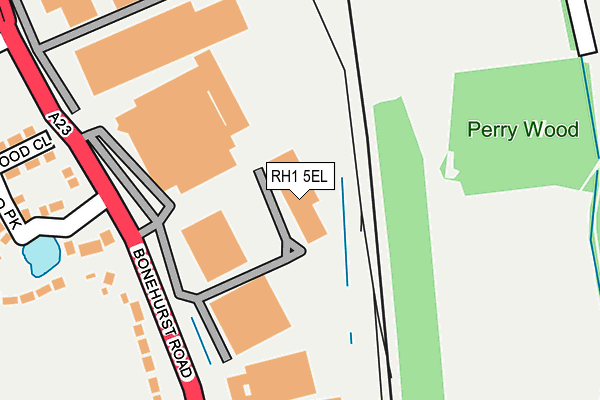
RH1 5EL is located in the Horley East & Salfords electoral ward, within the local authority district of Reigate and Banstead and the English Parliamentary constituency of Reigate. The Sub Integrated Care Board (ICB) Location is NHS Surrey Heartlands ICB - 92A and the police force is Surrey. This postcode has been in use since July 1990.


GetTheData
Source: OS OpenMap – Local (Ordnance Survey)
Source: OS VectorMap District (Ordnance Survey)
Licence: Open Government Licence (requires attribution)
| Easting | 528429 |
| Northing | 145822 |
| Latitude | 51.197188 |
| Longitude | -0.163273 |
GetTheData
Source: Open Postcode Geo
Licence: Open Government Licence
| Country | England |
| Postcode District | RH1 |
➜ See where RH1 is on a map ➜ Where is Salfords? | |
GetTheData
Source: Land Registry Price Paid Data
Licence: Open Government Licence
Elevation or altitude of RH1 5EL as distance above sea level:
| Metres | Feet | |
|---|---|---|
| Elevation | 70m | 230ft |
Elevation is measured from the approximate centre of the postcode, to the nearest point on an OS contour line from OS Terrain 50, which has contour spacing of ten vertical metres.
➜ How high above sea level am I? Find the elevation of your current position using your device's GPS.
GetTheData
Source: Open Postcode Elevation
Licence: Open Government Licence
| Ward | Horley East & Salfords |
| Constituency | Reigate |
GetTheData
Source: ONS Postcode Database
Licence: Open Government Licence
| Wood Close (Bonehurst Road) | Salfords | 167m |
| Pear Tree Hill (Bonehurst Road) | Salfords | 178m |
| Pear Tree Hill (Bonehurst Road) | Salfords | 200m |
| Wood Close (Bonehurst Road) | Salfords | 205m |
| Salbrook Road (Bonehurst Road) | Salfords | 478m |
| Salfords (Surrey) Station | 0.5km |
| Horley Station | 3.2km |
| Earlswood (Surrey) Station | 3.4km |
GetTheData
Source: NaPTAN
Licence: Open Government Licence
GetTheData
Source: ONS Postcode Database
Licence: Open Government Licence


➜ Get more ratings from the Food Standards Agency
GetTheData
Source: Food Standards Agency
Licence: FSA terms & conditions
| Last Collection | |||
|---|---|---|---|
| Location | Mon-Fri | Sat | Distance |
| Vines Garage | 17:30 | 12:30 | 195m |
| Beechwood Villas | 16:30 | 12:30 | 506m |
| Westmead Drive | 17:30 | 12:15 | 578m |
GetTheData
Source: Dracos
Licence: Creative Commons Attribution-ShareAlike
The below table lists the International Territorial Level (ITL) codes (formerly Nomenclature of Territorial Units for Statistics (NUTS) codes) and Local Administrative Units (LAU) codes for RH1 5EL:
| ITL 1 Code | Name |
|---|---|
| TLJ | South East (England) |
| ITL 2 Code | Name |
| TLJ2 | Surrey, East and West Sussex |
| ITL 3 Code | Name |
| TLJ26 | East Surrey |
| LAU 1 Code | Name |
| E07000211 | Reigate and Banstead |
GetTheData
Source: ONS Postcode Directory
Licence: Open Government Licence
The below table lists the Census Output Area (OA), Lower Layer Super Output Area (LSOA), and Middle Layer Super Output Area (MSOA) for RH1 5EL:
| Code | Name | |
|---|---|---|
| OA | E00156204 | |
| LSOA | E01030628 | Reigate and Banstead 015A |
| MSOA | E02006389 | Reigate and Banstead 015 |
GetTheData
Source: ONS Postcode Directory
Licence: Open Government Licence
| RH1 5ED | Bonehurst Road | 167m |
| RH1 5EG | Pear Tree Hill | 173m |
| RH1 5EJ | Harwood Park | 227m |
| RH1 5GH | Fairlawn Enterprise Park | 228m |
| RH1 5EE | Wood Close | 248m |
| RH1 5GJ | Salbrook Road | 311m |
| RH1 5EA | Horley Lodge Lane | 395m |
| RH1 5EB | Oak Lodge Drive | 462m |
| RH1 5DL | White Lodge Gardens | 490m |
| RH1 5EY | Beechwood Villas | 495m |
GetTheData
Source: Open Postcode Geo; Land Registry Price Paid Data
Licence: Open Government Licence