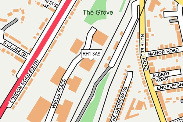
RH1 3AS is located in the Hooley, Merstham & Netherne electoral ward, within the local authority district of Reigate and Banstead and the English Parliamentary constituency of Reigate. The Sub Integrated Care Board (ICB) Location is NHS Surrey Heartlands ICB - 92A and the police force is Surrey. This postcode has been in use since July 2003.


GetTheData
Source: OS OpenMap – Local (Ordnance Survey)
Source: OS VectorMap District (Ordnance Survey)
Licence: Open Government Licence (requires attribution)
| Easting | 528937 |
| Northing | 152689 |
| Latitude | 51.258792 |
| Longitude | -0.153565 |
GetTheData
Source: Open Postcode Geo
Licence: Open Government Licence
| Country | England |
| Postcode District | RH1 |
➜ See where RH1 is on a map ➜ Where is South Merstham? | |
GetTheData
Source: Land Registry Price Paid Data
Licence: Open Government Licence
Elevation or altitude of RH1 3AS as distance above sea level:
| Metres | Feet | |
|---|---|---|
| Elevation | 90m | 295ft |
Elevation is measured from the approximate centre of the postcode, to the nearest point on an OS contour line from OS Terrain 50, which has contour spacing of ten vertical metres.
➜ How high above sea level am I? Find the elevation of your current position using your device's GPS.
GetTheData
Source: Open Postcode Elevation
Licence: Open Government Licence
| Ward | Hooley, Merstham & Netherne |
| Constituency | Reigate |
GetTheData
Source: ONS Postcode Database
Licence: Open Government Licence
| The Grove (London Road South) | Merstham | 165m |
| The Grove (London Road South) | Merstham | 174m |
| Manor Road | Merstham | 198m |
| Nutfield Road | South Merstham | 275m |
| Church (Battlebridge Lane) | South Merstham | 282m |
| Merstham Station | 0.6km |
| Redhill Station | 2.2km |
| Earlswood (Surrey) Station | 3.7km |
GetTheData
Source: NaPTAN
Licence: Open Government Licence
GetTheData
Source: ONS Postcode Database
Licence: Open Government Licence


➜ Get more ratings from the Food Standards Agency
GetTheData
Source: Food Standards Agency
Licence: FSA terms & conditions
| Last Collection | |||
|---|---|---|---|
| Location | Mon-Fri | Sat | Distance |
| Bushetts Close | 17:15 | 12:00 | 206m |
| South Merstham P O | 17:15 | 12:00 | 239m |
| Sub Rosa Caravan Park | 17:30 | 12:00 | 432m |
GetTheData
Source: Dracos
Licence: Creative Commons Attribution-ShareAlike
The below table lists the International Territorial Level (ITL) codes (formerly Nomenclature of Territorial Units for Statistics (NUTS) codes) and Local Administrative Units (LAU) codes for RH1 3AS:
| ITL 1 Code | Name |
|---|---|
| TLJ | South East (England) |
| ITL 2 Code | Name |
| TLJ2 | Surrey, East and West Sussex |
| ITL 3 Code | Name |
| TLJ26 | East Surrey |
| LAU 1 Code | Name |
| E07000211 | Reigate and Banstead |
GetTheData
Source: ONS Postcode Directory
Licence: Open Government Licence
The below table lists the Census Output Area (OA), Lower Layer Super Output Area (LSOA), and Middle Layer Super Output Area (MSOA) for RH1 3AS:
| Code | Name | |
|---|---|---|
| OA | E00156058 | |
| LSOA | E01030598 | Reigate and Banstead 009A |
| MSOA | E02006383 | Reigate and Banstead 009 |
GetTheData
Source: ONS Postcode Directory
Licence: Open Government Licence
| RH1 3AX | London Road South | 136m |
| RH1 3NA | The Crossways | 150m |
| RH1 3EW | Nutfield Road | 151m |
| RH1 3EN | Nutfield Road | 189m |
| RH1 3EL | Nutfield Road | 225m |
| RH1 3AY | Rookwood Close | 246m |
| RH1 3DX | Bushetts Grove | 252m |
| RH1 3LT | Manor Road | 258m |
| RH1 3ER | Nutfield Road | 260m |
| RH1 3EB | Nutfield Road | 262m |
GetTheData
Source: Open Postcode Geo; Land Registry Price Paid Data
Licence: Open Government Licence