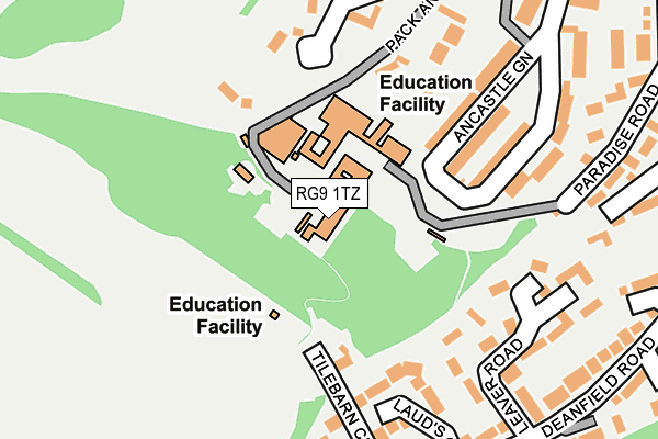
RG9 1TZ is located in the Henley-on-Thames electoral ward, within the local authority district of South Oxfordshire and the English Parliamentary constituency of Henley. The Sub Integrated Care Board (ICB) Location is NHS Buckinghamshire, Oxfordshire and Berkshire West ICB - 10Q and the police force is Thames Valley. This postcode has been in use since January 1980.


GetTheData
Source: OS OpenMap – Local (Ordnance Survey)
Source: OS VectorMap District (Ordnance Survey)
Licence: Open Government Licence (requires attribution)
| Easting | 475312 |
| Northing | 182374 |
| Latitude | 51.535259 |
| Longitude | -0.915565 |
GetTheData
Source: Open Postcode Geo
Licence: Open Government Licence
| Country | England |
| Postcode District | RG9 |
➜ See where RG9 is on a map ➜ Where is Henley-on-Thames? | |
GetTheData
Source: Land Registry Price Paid Data
Licence: Open Government Licence
Elevation or altitude of RG9 1TZ as distance above sea level:
| Metres | Feet | |
|---|---|---|
| Elevation | 70m | 230ft |
Elevation is measured from the approximate centre of the postcode, to the nearest point on an OS contour line from OS Terrain 50, which has contour spacing of ten vertical metres.
➜ How high above sea level am I? Find the elevation of your current position using your device's GPS.
GetTheData
Source: Open Postcode Elevation
Licence: Open Government Licence
| Ward | Henley-on-thames |
| Constituency | Henley |
GetTheData
Source: ONS Postcode Database
Licence: Open Government Licence
| Deanfield Road | Henley-on-thames | 282m |
| Deanfield Avenue | Henley-on-thames | 341m |
| The Close (Greys Road) | Henley-on-thames | 524m |
| The Close (Greys Road) | Henley-on-thames | 525m |
| Valley Road | Henley-on-thames | 571m |
| Henley-on-Thames Station | 1.1km |
| Shiplake Station | 3.5km |
| Wargrave Station | 4.9km |
GetTheData
Source: NaPTAN
Licence: Open Government Licence
GetTheData
Source: ONS Postcode Database
Licence: Open Government Licence


➜ Get more ratings from the Food Standards Agency
GetTheData
Source: Food Standards Agency
Licence: FSA terms & conditions
| Last Collection | |||
|---|---|---|---|
| Location | Mon-Fri | Sat | Distance |
| Gravel Hill | 17:15 | 11:00 | 385m |
| Waitrose Stores | 18:15 | 11:00 | 773m |
| Market Place | 18:15 | 11:00 | 774m |
GetTheData
Source: Dracos
Licence: Creative Commons Attribution-ShareAlike
The below table lists the International Territorial Level (ITL) codes (formerly Nomenclature of Territorial Units for Statistics (NUTS) codes) and Local Administrative Units (LAU) codes for RG9 1TZ:
| ITL 1 Code | Name |
|---|---|
| TLJ | South East (England) |
| ITL 2 Code | Name |
| TLJ1 | Berkshire, Buckinghamshire and Oxfordshire |
| ITL 3 Code | Name |
| TLJ14 | Oxfordshire CC |
| LAU 1 Code | Name |
| E07000179 | South Oxfordshire |
GetTheData
Source: ONS Postcode Directory
Licence: Open Government Licence
The below table lists the Census Output Area (OA), Lower Layer Super Output Area (LSOA), and Middle Layer Super Output Area (MSOA) for RG9 1TZ:
| Code | Name | |
|---|---|---|
| OA | E00145938 | |
| LSOA | E01028651 | South Oxfordshire 016B |
| MSOA | E02005973 | South Oxfordshire 016 |
GetTheData
Source: ONS Postcode Directory
Licence: Open Government Licence
| RG9 1UX | Lauds Close | 157m |
| RG9 1TR | Ancastle Green | 167m |
| RG9 1UW | Leaver Road | 195m |
| RG9 1TS | Ancastle Green | 196m |
| RG9 1TX | Parkside | 203m |
| RG9 1TT | Pack & Prime Lane | 206m |
| RG9 1US | Tilebarn Close | 230m |
| RG9 1UB | Paradise Road | 242m |
| RG9 1UQ | Ancastle Green | 268m |
| RG9 1UU | Deanfield Road | 273m |
GetTheData
Source: Open Postcode Geo; Land Registry Price Paid Data
Licence: Open Government Licence