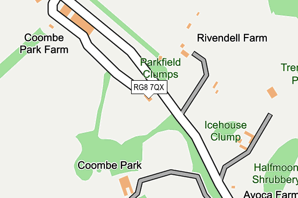
RG8 7QX lies on Hartslock Road in Whitchurch On Thames, Reading. RG8 7QX is located in the Kidmore End & Whitchurch electoral ward, within the local authority district of South Oxfordshire and the English Parliamentary constituency of Henley. The Sub Integrated Care Board (ICB) Location is NHS Buckinghamshire, Oxfordshire and Berkshire West ICB - 10Q and the police force is Thames Valley. This postcode has been in use since January 1980.


GetTheData
Source: OS OpenMap – Local (Ordnance Survey)
Source: OS VectorMap District (Ordnance Survey)
Licence: Open Government Licence (requires attribution)
| Easting | 462780 |
| Northing | 177978 |
| Latitude | 51.497265 |
| Longitude | -1.097019 |
GetTheData
Source: Open Postcode Geo
Licence: Open Government Licence
| Street | Hartslock Road |
| Locality | Whitchurch On Thames |
| Town/City | Reading |
| Country | England |
| Postcode District | RG8 |
➜ See where RG8 is on a map | |
GetTheData
Source: Land Registry Price Paid Data
Licence: Open Government Licence
Elevation or altitude of RG8 7QX as distance above sea level:
| Metres | Feet | |
|---|---|---|
| Elevation | 70m | 230ft |
Elevation is measured from the approximate centre of the postcode, to the nearest point on an OS contour line from OS Terrain 50, which has contour spacing of ten vertical metres.
➜ How high above sea level am I? Find the elevation of your current position using your device's GPS.
GetTheData
Source: Open Postcode Elevation
Licence: Open Government Licence
| Ward | Kidmore End & Whitchurch |
| Constituency | Henley |
GetTheData
Source: ONS Postcode Database
Licence: Open Government Licence
| Hardwick Road (High Street) | Whitchurch-on-thames | 827m |
| Hardwick Road (High Street) | Whitchurch-on-thames | 829m |
| Northridge Bottom Plantation (Shooters Hill) | Pangbourne | 898m |
| Beale Park (A329 Shooters Hill) | Beale Wildlife Park | 942m |
| Beale Park (A329 Shooters Hill) | Beale Wildlife Park | 956m |
| Pangbourne Station | 1.4km |
| Goring & Streatley Station | 3.7km |
| Tilehurst Station | 5.5km |
GetTheData
Source: NaPTAN
Licence: Open Government Licence
| Percentage of properties with Next Generation Access | 100.0% |
| Percentage of properties with Superfast Broadband | 40.0% |
| Percentage of properties with Ultrafast Broadband | 0.0% |
| Percentage of properties with Full Fibre Broadband | 0.0% |
Superfast Broadband is between 30Mbps and 300Mbps
Ultrafast Broadband is > 300Mbps
| Median download speed | 14.3Mbps |
| Average download speed | 14.8Mbps |
| Maximum download speed | 22.22Mbps |
| Median upload speed | 1.2Mbps |
| Average upload speed | 2.3Mbps |
| Maximum upload speed | 6.87Mbps |
| Percentage of properties unable to receive 2Mbps | 0.0% |
| Percentage of properties unable to receive 5Mbps | 0.0% |
| Percentage of properties unable to receive 10Mbps | 0.0% |
| Percentage of properties unable to receive 30Mbps | 60.0% |
GetTheData
Source: Ofcom
Licence: Ofcom Terms of Use (requires attribution)
Estimated total energy consumption in RG8 7QX by fuel type, 2015.
| Consumption (kWh) | 106,767 |
|---|---|
| Meter count | 10 |
| Mean (kWh/meter) | 10,677 |
| Median (kWh/meter) | 5,048 |
GetTheData
Source: Postcode level gas estimates: 2015 (experimental)
Source: Postcode level electricity estimates: 2015 (experimental)
Licence: Open Government Licence
GetTheData
Source: ONS Postcode Database
Licence: Open Government Licence


➜ Get more ratings from the Food Standards Agency
GetTheData
Source: Food Standards Agency
Licence: FSA terms & conditions
| Last Collection | |||
|---|---|---|---|
| Location | Mon-Fri | Sat | Distance |
| Railway Station | 17:00 | 11:45 | 1,389m |
| Path Hill | 16:30 | 07:00 | 2,423m |
| Crays Pond | 16:15 | 09:45 | 2,799m |
GetTheData
Source: Dracos
Licence: Creative Commons Attribution-ShareAlike
The below table lists the International Territorial Level (ITL) codes (formerly Nomenclature of Territorial Units for Statistics (NUTS) codes) and Local Administrative Units (LAU) codes for RG8 7QX:
| ITL 1 Code | Name |
|---|---|
| TLJ | South East (England) |
| ITL 2 Code | Name |
| TLJ1 | Berkshire, Buckinghamshire and Oxfordshire |
| ITL 3 Code | Name |
| TLJ14 | Oxfordshire CC |
| LAU 1 Code | Name |
| E07000179 | South Oxfordshire |
GetTheData
Source: ONS Postcode Directory
Licence: Open Government Licence
The below table lists the Census Output Area (OA), Lower Layer Super Output Area (LSOA), and Middle Layer Super Output Area (MSOA) for RG8 7QX:
| Code | Name | |
|---|---|---|
| OA | E00145908 | |
| LSOA | E01028643 | South Oxfordshire 018C |
| MSOA | E02005975 | South Oxfordshire 018 |
GetTheData
Source: ONS Postcode Directory
Licence: Open Government Licence
| RG8 7NT | 504m | |
| RG8 7EU | Manor Road | 715m |
| RG8 7HA | High Street | 758m |
| RG8 7HF | High Street | 776m |
| RG8 7EY | High Street | 798m |
| RG8 7HG | High Street | 801m |
| RG8 7EW | Manor Road | 836m |
| RG8 7HH | Hardwick Road | 851m |
| RG8 7EX | High Street | 857m |
| RG8 7EZ | Old Barn Cottages | 899m |
GetTheData
Source: Open Postcode Geo; Land Registry Price Paid Data
Licence: Open Government Licence