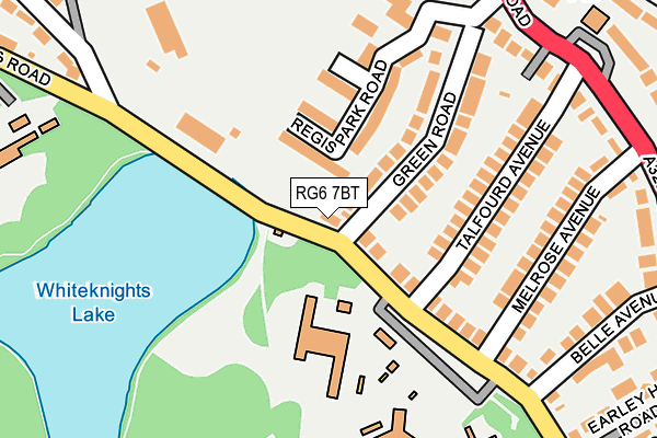
RG6 7BT lies on Whiteknights Road in Reading. RG6 7BT is located in the Park electoral ward, within the unitary authority of Reading and the English Parliamentary constituency of Reading East. The Sub Integrated Care Board (ICB) Location is NHS Buckinghamshire, Oxfordshire and Berkshire West ICB - 15A and the police force is Thames Valley. This postcode has been in use since July 1995.


GetTheData
Source: OS OpenMap – Local (Ordnance Survey)
Source: OS VectorMap District (Ordnance Survey)
Licence: Open Government Licence (requires attribution)
| Easting | 473930 |
| Northing | 172277 |
| Latitude | 51.444668 |
| Longitude | -0.937617 |
GetTheData
Source: Open Postcode Geo
Licence: Open Government Licence
| Street | Whiteknights Road |
| Town/City | Reading |
| Country | England |
| Postcode District | RG6 |
➜ See where RG6 is on a map ➜ Where is Reading? | |
GetTheData
Source: Land Registry Price Paid Data
Licence: Open Government Licence
Elevation or altitude of RG6 7BT as distance above sea level:
| Metres | Feet | |
|---|---|---|
| Elevation | 60m | 197ft |
Elevation is measured from the approximate centre of the postcode, to the nearest point on an OS contour line from OS Terrain 50, which has contour spacing of ten vertical metres.
➜ How high above sea level am I? Find the elevation of your current position using your device's GPS.
GetTheData
Source: Open Postcode Elevation
Licence: Open Government Licence
| Ward | Park |
| Constituency | Reading East |
GetTheData
Source: ONS Postcode Database
Licence: Open Government Licence
| Bridges Hall (Whiteknights Road) | Whiteknights | 143m |
| Bridges Hall (Whiteknights Road) | Whiteknights | 170m |
| Mockbeggar (Whiteknights Road) | Whiteknights | 186m |
| Mockbeggar (Whiteknights Road) | Whiteknights | 261m |
| Melrose Avenue (Wokingham Road) | Whiteknights | 270m |
| Earley Station | 1.4km |
| Reading Station | 2.9km |
| Winnersh Triangle Station | 3.3km |
GetTheData
Source: NaPTAN
Licence: Open Government Licence
| Percentage of properties with Next Generation Access | 100.0% |
| Percentage of properties with Superfast Broadband | 100.0% |
| Percentage of properties with Ultrafast Broadband | 50.0% |
| Percentage of properties with Full Fibre Broadband | 0.0% |
Superfast Broadband is between 30Mbps and 300Mbps
Ultrafast Broadband is > 300Mbps
| Percentage of properties unable to receive 2Mbps | 0.0% |
| Percentage of properties unable to receive 5Mbps | 0.0% |
| Percentage of properties unable to receive 10Mbps | 0.0% |
| Percentage of properties unable to receive 30Mbps | 0.0% |
GetTheData
Source: Ofcom
Licence: Ofcom Terms of Use (requires attribution)
GetTheData
Source: ONS Postcode Database
Licence: Open Government Licence


➜ Get more ratings from the Food Standards Agency
GetTheData
Source: Food Standards Agency
Licence: FSA terms & conditions
| Last Collection | |||
|---|---|---|---|
| Location | Mon-Fri | Sat | Distance |
| Whiteknights Road | 16:00 | 10:30 | 96m |
| Wokingham Road Post Office | 17:00 | 12:00 | 457m |
| Bp 324 Wokingham Road | 16:00 | 10:30 | 493m |
GetTheData
Source: Dracos
Licence: Creative Commons Attribution-ShareAlike
The below table lists the International Territorial Level (ITL) codes (formerly Nomenclature of Territorial Units for Statistics (NUTS) codes) and Local Administrative Units (LAU) codes for RG6 7BT:
| ITL 1 Code | Name |
|---|---|
| TLJ | South East (England) |
| ITL 2 Code | Name |
| TLJ1 | Berkshire, Buckinghamshire and Oxfordshire |
| ITL 3 Code | Name |
| TLJ11 | Berkshire |
| LAU 1 Code | Name |
| E06000038 | Reading |
GetTheData
Source: ONS Postcode Directory
Licence: Open Government Licence
The below table lists the Census Output Area (OA), Lower Layer Super Output Area (LSOA), and Middle Layer Super Output Area (MSOA) for RG6 7BT:
| Code | Name | |
|---|---|---|
| OA | E00082861 | |
| LSOA | E01016403 | Reading 012B |
| MSOA | E02003400 | Reading 012 |
GetTheData
Source: ONS Postcode Directory
Licence: Open Government Licence
| RG6 7BS | Green Road | 106m |
| RG6 7AD | Regis Park Road | 116m |
| RG6 7BP | Talfourd Avenue | 148m |
| RG6 7AE | Regis Park Road | 153m |
| RG6 7AF | Regis Park Road | 180m |
| RG6 7BN | Melrose Avenue | 196m |
| RG6 7BL | Belle Avenue | 249m |
| RG6 6BG | Whiteknights Road | 258m |
| RG6 7BB | Whiteknights Road | 262m |
| RG6 1JS | Wokingham Road | 262m |
GetTheData
Source: Open Postcode Geo; Land Registry Price Paid Data
Licence: Open Government Licence