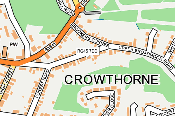
RG45 7DD lies on Upper Broadmoor Road in Crowthorne. RG45 7DD is located in the Crowthorne electoral ward, within the unitary authority of Bracknell Forest and the English Parliamentary constituency of Bracknell. The Sub Integrated Care Board (ICB) Location is NHS Frimley ICB - D4U1Y and the police force is Thames Valley. This postcode has been in use since July 1995.


GetTheData
Source: OS OpenMap – Local (Ordnance Survey)
Source: OS VectorMap District (Ordnance Survey)
Licence: Open Government Licence (requires attribution)
| Easting | 484443 |
| Northing | 164192 |
| Latitude | 51.370519 |
| Longitude | -0.788286 |
GetTheData
Source: Open Postcode Geo
Licence: Open Government Licence
| Street | Upper Broadmoor Road |
| Town/City | Crowthorne |
| Country | England |
| Postcode District | RG45 |
➜ See where RG45 is on a map ➜ Where is Crowthorne? | |
GetTheData
Source: Land Registry Price Paid Data
Licence: Open Government Licence
Elevation or altitude of RG45 7DD as distance above sea level:
| Metres | Feet | |
|---|---|---|
| Elevation | 100m | 328ft |
Elevation is measured from the approximate centre of the postcode, to the nearest point on an OS contour line from OS Terrain 50, which has contour spacing of ten vertical metres.
➜ How high above sea level am I? Find the elevation of your current position using your device's GPS.
GetTheData
Source: Open Postcode Elevation
Licence: Open Government Licence
| Ward | Crowthorne |
| Constituency | Bracknell |
GetTheData
Source: ONS Postcode Database
Licence: Open Government Licence
| High Street (Dukes Ride) | Crowthorne | 225m |
| High Street | Crowthorne | 278m |
| High Street (Dukes Ride) | Crowthorne | 376m |
| Brookers Row (Old Wokingham Road) | Crowthorne | 484m |
| Brookers Row (Old Wokingham Road) | Crowthorne | 531m |
| Crowthorne Station | 2.2km |
| Sandhurst Station | 2.9km |
| Blackwater Station | 4.4km |
GetTheData
Source: NaPTAN
Licence: Open Government Licence
| Percentage of properties with Next Generation Access | 100.0% |
| Percentage of properties with Superfast Broadband | 100.0% |
| Percentage of properties with Ultrafast Broadband | 0.0% |
| Percentage of properties with Full Fibre Broadband | 0.0% |
Superfast Broadband is between 30Mbps and 300Mbps
Ultrafast Broadband is > 300Mbps
| Percentage of properties unable to receive 2Mbps | 0.0% |
| Percentage of properties unable to receive 5Mbps | 0.0% |
| Percentage of properties unable to receive 10Mbps | 0.0% |
| Percentage of properties unable to receive 30Mbps | 0.0% |
GetTheData
Source: Ofcom
Licence: Ofcom Terms of Use (requires attribution)
GetTheData
Source: ONS Postcode Database
Licence: Open Government Licence


➜ Get more ratings from the Food Standards Agency
GetTheData
Source: Food Standards Agency
Licence: FSA terms & conditions
| Last Collection | |||
|---|---|---|---|
| Location | Mon-Fri | Sat | Distance |
| Napier Road | 16:30 | 11:45 | 270m |
| Dukes Ride Post Office | 17:15 | 12:00 | 290m |
| Pinewood Avenue | 16:00 | 11:00 | 410m |
GetTheData
Source: Dracos
Licence: Creative Commons Attribution-ShareAlike
The below table lists the International Territorial Level (ITL) codes (formerly Nomenclature of Territorial Units for Statistics (NUTS) codes) and Local Administrative Units (LAU) codes for RG45 7DD:
| ITL 1 Code | Name |
|---|---|
| TLJ | South East (England) |
| ITL 2 Code | Name |
| TLJ1 | Berkshire, Buckinghamshire and Oxfordshire |
| ITL 3 Code | Name |
| TLJ11 | Berkshire |
| LAU 1 Code | Name |
| E06000036 | Bracknell Forest |
GetTheData
Source: ONS Postcode Directory
Licence: Open Government Licence
The below table lists the Census Output Area (OA), Lower Layer Super Output Area (LSOA), and Middle Layer Super Output Area (MSOA) for RG45 7DD:
| Code | Name | |
|---|---|---|
| OA | E00081898 | |
| LSOA | E01016207 | Bracknell Forest 013A |
| MSOA | E02003364 | Bracknell Forest 013 |
GetTheData
Source: ONS Postcode Directory
Licence: Open Government Licence
| RG45 7BY | Upper Broadmoor Road | 27m |
| RG45 7DE | Upper Broadmoor Road | 46m |
| RG45 7DB | Upper Broadmoor Road | 48m |
| RG45 7DH | Upper Broadmoor Road | 48m |
| RG45 7DY | Brookers Corner | 55m |
| RG45 7DA | Upper Broadmoor Road | 78m |
| RG45 7DT | Brookers Corner | 79m |
| RG45 7DU | Brookers Corner | 80m |
| RG45 7DQ | Upper Broadmoor Road | 84m |
| RG45 7BZ | Upper Broadmoor Road | 90m |
GetTheData
Source: Open Postcode Geo; Land Registry Price Paid Data
Licence: Open Government Licence