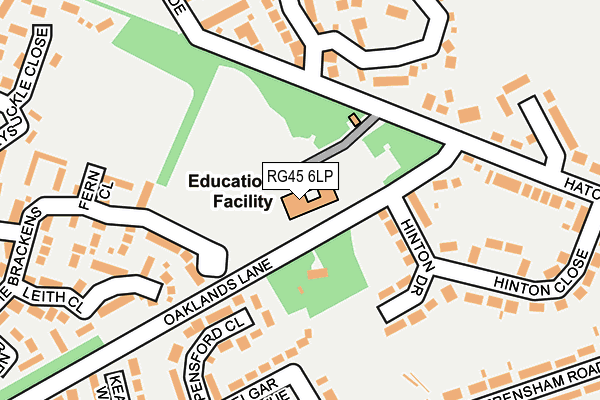
RG45 6LP is located in the Wokingham Without electoral ward, within the unitary authority of Wokingham and the English Parliamentary constituency of Bracknell. The Sub Integrated Care Board (ICB) Location is NHS Buckinghamshire, Oxfordshire and Berkshire West ICB - 15A and the police force is Thames Valley. This postcode has been in use since July 1995.


GetTheData
Source: OS OpenMap – Local (Ordnance Survey)
Source: OS VectorMap District (Ordnance Survey)
Licence: Open Government Licence (requires attribution)
| Easting | 483709 |
| Northing | 165228 |
| Latitude | 51.379941 |
| Longitude | -0.798601 |
GetTheData
Source: Open Postcode Geo
Licence: Open Government Licence
| Country | England |
| Postcode District | RG45 |
➜ See where RG45 is on a map ➜ Where is Crowthorne? | |
GetTheData
Source: Land Registry Price Paid Data
Licence: Open Government Licence
Elevation or altitude of RG45 6LP as distance above sea level:
| Metres | Feet | |
|---|---|---|
| Elevation | 70m | 230ft |
Elevation is measured from the approximate centre of the postcode, to the nearest point on an OS contour line from OS Terrain 50, which has contour spacing of ten vertical metres.
➜ How high above sea level am I? Find the elevation of your current position using your device's GPS.
GetTheData
Source: Open Postcode Elevation
Licence: Open Government Licence
| Ward | Wokingham Without |
| Constituency | Bracknell |
GetTheData
Source: ONS Postcode Database
Licence: Open Government Licence
| St Sebastians Roundabout (New Wokingham Road) | Bigshotte Park | 481m |
| Trl Western Entrance (Old Wokingham Road) | Transport Research Laboratory | 501m |
| Trl Western Entrance (Old Wokingham Road) | Transport Research Laboratory | 510m |
| St Sebastians Roundabout (New Wokingham Road) | Bigshotte Park | 539m |
| Pinewood Crossroads (Old Wokingham Road) | Crowthorne | 625m |
| Crowthorne Station | 2.1km |
| Sandhurst Station | 3.7km |
| Wokingham Station | 4.6km |
GetTheData
Source: NaPTAN
Licence: Open Government Licence
GetTheData
Source: ONS Postcode Database
Licence: Open Government Licence


➜ Get more ratings from the Food Standards Agency
GetTheData
Source: Food Standards Agency
Licence: FSA terms & conditions
| Last Collection | |||
|---|---|---|---|
| Location | Mon-Fri | Sat | Distance |
| Greenwood Road | 17:00 | 11:00 | 336m |
| The Conifers | 16:00 | 11:00 | 468m |
| Ellis Road | 17:00 | 11:00 | 691m |
GetTheData
Source: Dracos
Licence: Creative Commons Attribution-ShareAlike
The below table lists the International Territorial Level (ITL) codes (formerly Nomenclature of Territorial Units for Statistics (NUTS) codes) and Local Administrative Units (LAU) codes for RG45 6LP:
| ITL 1 Code | Name |
|---|---|
| TLJ | South East (England) |
| ITL 2 Code | Name |
| TLJ1 | Berkshire, Buckinghamshire and Oxfordshire |
| ITL 3 Code | Name |
| TLJ11 | Berkshire |
| LAU 1 Code | Name |
| E06000041 | Wokingham |
GetTheData
Source: ONS Postcode Directory
Licence: Open Government Licence
The below table lists the Census Output Area (OA), Lower Layer Super Output Area (LSOA), and Middle Layer Super Output Area (MSOA) for RG45 6LP:
| Code | Name | |
|---|---|---|
| OA | E00084318 | |
| LSOA | E01016707 | Wokingham 020C |
| MSOA | E02003458 | Wokingham 020 |
GetTheData
Source: ONS Postcode Directory
Licence: Open Government Licence
| RG45 6JY | Hinton Drive | 121m |
| RG45 6QR | Pensford Close | 169m |
| RG45 6TS | Fern Close | 188m |
| RG45 6LD | Hatch Ride | 201m |
| RG45 6QN | Purcell Road | 222m |
| RG45 6QP | Elgar Avenue | 231m |
| RG45 6LA | Hinton Close | 235m |
| RG45 6TD | Leith Close | 242m |
| RG45 6QS | Keats Way | 252m |
| RG45 6TB | The Brackens | 256m |
GetTheData
Source: Open Postcode Geo; Land Registry Price Paid Data
Licence: Open Government Licence