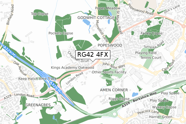
RG42 4FX is located in the Binfield South & Jennett's Park electoral ward, within the unitary authority of Bracknell Forest and the English Parliamentary constituency of Windsor. The Sub Integrated Care Board (ICB) Location is NHS Frimley ICB - D4U1Y and the police force is Thames Valley. This postcode has been in use since February 2018.


GetTheData
Source: OS Open Zoomstack (Ordnance Survey)
Licence: Open Government Licence (requires attribution)
Attribution: Contains OS data © Crown copyright and database right 2025
Source: Open Postcode Geo
Licence: Open Government Licence (requires attribution)
Attribution: Contains OS data © Crown copyright and database right 2025; Contains Royal Mail data © Royal Mail copyright and database right 2025; Source: Office for National Statistics licensed under the Open Government Licence v.3.0
| Easting | 484138 |
| Northing | 169236 |
| Latitude | 51.415909 |
| Longitude | -0.791473 |
GetTheData
Source: Open Postcode Geo
Licence: Open Government Licence
| Country | England |
| Postcode District | RG42 |
➜ See where RG42 is on a map ➜ Where is Bracknell? | |
GetTheData
Source: Land Registry Price Paid Data
Licence: Open Government Licence
| Ward | Binfield South & Jennett's Park |
| Constituency | Windsor |
GetTheData
Source: ONS Postcode Database
Licence: Open Government Licence
2022 21 MAR £635,000 |
3, GOLD PLACE, BINFIELD, BRACKNELL, RG42 4FX 2022 14 JAN £715,000 |
6, GOLD PLACE, BINFIELD, BRACKNELL, RG42 4FX 2021 9 APR £660,000 |
5, GOLD PLACE, BINFIELD, BRACKNELL, RG42 4FX 2021 18 MAR £675,000 |
2018 22 OCT £620,000 |
GetTheData
Source: HM Land Registry Price Paid Data
Licence: Contains HM Land Registry data © Crown copyright and database right 2025. This data is licensed under the Open Government Licence v3.0.
| Merydene Court (London Road) | Popeswood | 181m |
| Merydene Court (London Road) | Popeswood | 240m |
| Coppid Beech Hill (London Road) | Amen Corner | 243m |
| Coppid Beech Hill (London Road) | Amen Corner | 251m |
| Ski Centre (John Nike Way) | John Nike Leisure Centre | 355m |
| Bracknell Station | 2.8km |
| Wokingham Station | 3.6km |
| Martins Heron Station | 4.8km |
GetTheData
Source: NaPTAN
Licence: Open Government Licence
| Percentage of properties with Next Generation Access | 100.0% |
| Percentage of properties with Superfast Broadband | 100.0% |
| Percentage of properties with Ultrafast Broadband | 100.0% |
| Percentage of properties with Full Fibre Broadband | 100.0% |
Superfast Broadband is between 30Mbps and 300Mbps
Ultrafast Broadband is > 300Mbps
| Percentage of properties unable to receive 2Mbps | 0.0% |
| Percentage of properties unable to receive 5Mbps | 0.0% |
| Percentage of properties unable to receive 10Mbps | 0.0% |
| Percentage of properties unable to receive 30Mbps | 0.0% |
GetTheData
Source: Ofcom
Licence: Ofcom Terms of Use (requires attribution)
GetTheData
Source: ONS Postcode Database
Licence: Open Government Licence


➜ Get more ratings from the Food Standards Agency
GetTheData
Source: Food Standards Agency
Licence: FSA terms & conditions
| Last Collection | |||
|---|---|---|---|
| Location | Mon-Fri | Sat | Distance |
| Ellisfield Avenue | 18:30 | 11:45 | 950m |
| Bean Oak Road | 16:45 | 11:15 | 1,034m |
| Turnpike Road | 17:30 | 10:45 | 1,065m |
GetTheData
Source: Dracos
Licence: Creative Commons Attribution-ShareAlike
The below table lists the International Territorial Level (ITL) codes (formerly Nomenclature of Territorial Units for Statistics (NUTS) codes) and Local Administrative Units (LAU) codes for RG42 4FX:
| ITL 1 Code | Name |
|---|---|
| TLJ | South East (England) |
| ITL 2 Code | Name |
| TLJ1 | Berkshire, Buckinghamshire and Oxfordshire |
| ITL 3 Code | Name |
| TLJ11 | Berkshire |
| LAU 1 Code | Name |
| E06000036 | Bracknell Forest |
GetTheData
Source: ONS Postcode Directory
Licence: Open Government Licence
The below table lists the Census Output Area (OA), Lower Layer Super Output Area (LSOA), and Middle Layer Super Output Area (MSOA) for RG42 4FX:
| Code | Name | |
|---|---|---|
| OA | E00166648 | |
| LSOA | E01016184 | Bracknell Forest 002A |
| MSOA | E02003353 | Bracknell Forest 002 |
GetTheData
Source: ONS Postcode Directory
Licence: Open Government Licence
| RG42 4BR | London Road | 186m |
| RG42 4BS | London Road | 225m |
| RG12 8TY | Braeside | 251m |
| RG42 4BT | London Road | 281m |
| RG12 8TX | Beehive Lane | 315m |
| RG12 8TU | Beehive Lane | 342m |
| RG42 4BU | Shaftesbury Place | 352m |
| RG12 8FH | Milward Gardens | 354m |
| RG12 8TW | Springfield Road | 410m |
| RG12 8TR | Beehive Road | 423m |
GetTheData
Source: Open Postcode Geo; Land Registry Price Paid Data
Licence: Open Government Licence