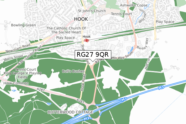
RG27 9QR is located in the Hook electoral ward, within the local authority district of Hart and the English Parliamentary constituency of North East Hampshire. The Sub Integrated Care Board (ICB) Location is NHS Hampshire and Isle of Wight ICB - D9Y0V and the police force is Hampshire. This postcode has been in use since September 2019.


GetTheData
Source: OS Open Zoomstack (Ordnance Survey)
Licence: Open Government Licence (requires attribution)
Attribution: Contains OS data © Crown copyright and database right 2025
Source: Open Postcode Geo
Licence: Open Government Licence (requires attribution)
Attribution: Contains OS data © Crown copyright and database right 2025; Contains Royal Mail data © Royal Mail copyright and database right 2025; Source: Office for National Statistics licensed under the Open Government Licence v.3.0
| Easting | 472591 |
| Northing | 153676 |
| Latitude | 51.277614 |
| Longitude | -0.960654 |
GetTheData
Source: Open Postcode Geo
Licence: Open Government Licence
| Country | England |
| Postcode District | RG27 |
➜ See where RG27 is on a map ➜ Where is Hook? | |
GetTheData
Source: Land Registry Price Paid Data
Licence: Open Government Licence
| Ward | Hook |
| Constituency | North East Hampshire |
GetTheData
Source: ONS Postcode Database
Licence: Open Government Licence
| Berry Court (Station Road) | Hook | 87m |
| Berry Court (Station Road) | Hook | 100m |
| Tesco Store (Osborn Way) | Hook | 187m |
| Rail Station (Station Road) | Hook | 331m |
| Rail Station (Station Road) | Hook | 384m |
| Hook Station | 0.3km |
| Winchfield Station | 3.8km |
GetTheData
Source: NaPTAN
Licence: Open Government Licence
| Percentage of properties with Next Generation Access | 0.0% |
| Percentage of properties with Superfast Broadband | 0.0% |
| Percentage of properties with Ultrafast Broadband | 0.0% |
| Percentage of properties with Full Fibre Broadband | 0.0% |
Superfast Broadband is between 30Mbps and 300Mbps
Ultrafast Broadband is > 300Mbps
| Percentage of properties unable to receive 2Mbps | 0.0% |
| Percentage of properties unable to receive 5Mbps | 0.0% |
| Percentage of properties unable to receive 10Mbps | 0.0% |
| Percentage of properties unable to receive 30Mbps | 100.0% |
GetTheData
Source: Ofcom
Licence: Ofcom Terms of Use (requires attribution)
GetTheData
Source: ONS Postcode Database
Licence: Open Government Licence


➜ Get more ratings from the Food Standards Agency
GetTheData
Source: Food Standards Agency
Licence: FSA terms & conditions
| Last Collection | |||
|---|---|---|---|
| Location | Mon-Fri | Sat | Distance |
| Hook Delivery Office | 18:30 | 10:45 | 154m |
| Rectory Road | 16:45 | 07:30 | 173m |
| Hook Delivery Office | 187m | ||
GetTheData
Source: Dracos
Licence: Creative Commons Attribution-ShareAlike
The below table lists the International Territorial Level (ITL) codes (formerly Nomenclature of Territorial Units for Statistics (NUTS) codes) and Local Administrative Units (LAU) codes for RG27 9QR:
| ITL 1 Code | Name |
|---|---|
| TLJ | South East (England) |
| ITL 2 Code | Name |
| TLJ3 | Hampshire and Isle of Wight |
| ITL 3 Code | Name |
| TLJ37 | North Hampshire |
| LAU 1 Code | Name |
| E07000089 | Hart |
GetTheData
Source: ONS Postcode Directory
Licence: Open Government Licence
The below table lists the Census Output Area (OA), Lower Layer Super Output Area (LSOA), and Middle Layer Super Output Area (MSOA) for RG27 9QR:
| Code | Name | |
|---|---|---|
| OA | E00116282 | |
| LSOA | E01022881 | Hart 006A |
| MSOA | E02004756 | Hart 006 |
GetTheData
Source: ONS Postcode Directory
Licence: Open Government Licence
| RG27 9JZ | Berry Court | 103m |
| RG27 9HY | Meridian Office Park | 185m |
| RG27 9JG | Rectory Road | 245m |
| RG27 9JH | Rectory Road | 262m |
| RG27 9HS | Station Road | 278m |
| RG27 9HT | Station Road | 314m |
| RG27 9QE | Valmeade Close | 322m |
| RG27 9QB | Compton Close | 335m |
| RG27 9HE | Station Road | 385m |
| RG27 9DF | Bell Meadow Road | 390m |
GetTheData
Source: Open Postcode Geo; Land Registry Price Paid Data
Licence: Open Government Licence