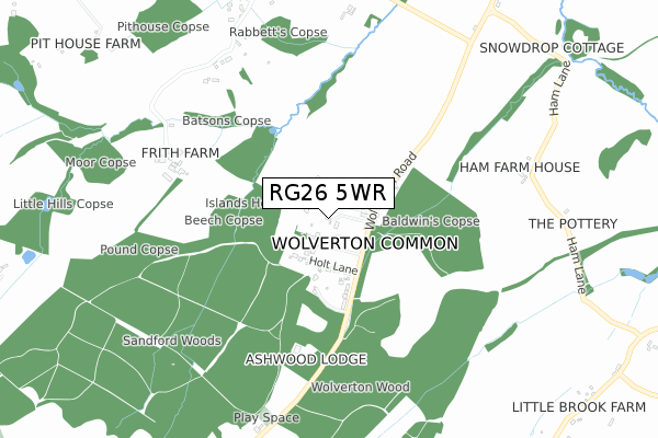
RG26 5WR is located in the Tadley North, Kingsclere & Baughurst electoral ward, within the local authority district of Basingstoke and Deane and the English Parliamentary constituency of North West Hampshire. The Sub Integrated Care Board (ICB) Location is NHS Hampshire and Isle of Wight ICB - D9Y0V and the police force is Hampshire. This postcode has been in use since September 2019.


GetTheData
Source: OS Open Zoomstack (Ordnance Survey)
Licence: Open Government Licence (requires attribution)
Attribution: Contains OS data © Crown copyright and database right 2025
Source: Open Postcode Geo
Licence: Open Government Licence (requires attribution)
Attribution: Contains OS data © Crown copyright and database right 2025; Contains Royal Mail data © Royal Mail copyright and database right 2025; Source: Office for National Statistics licensed under the Open Government Licence v.3.0
| Easting | 455952 |
| Northing | 159789 |
| Latitude | 51.334449 |
| Longitude | -1.198214 |
GetTheData
Source: Open Postcode Geo
Licence: Open Government Licence
| Country | England |
| Postcode District | RG26 |
➜ See where RG26 is on a map ➜ Where is Wolverton Common? | |
GetTheData
Source: Land Registry Price Paid Data
Licence: Open Government Licence
| Ward | Tadley North, Kingsclere & Baughurst |
| Constituency | North West Hampshire |
GetTheData
Source: ONS Postcode Database
Licence: Open Government Licence
| Holt Lane (Wolverton Road) | Wolverton Common | 217m |
| Holt Lane (Wolverton Road) | Wolverton Common | 238m |
| Fair Oak Farm (B3051) | Wheat Hold | 1,526m |
| Fair Oak Farm | Wheat Hold | 1,547m |
| Dairy House Farm (B3051 Little Knowl Hill) | Wheat Hold | 1,555m |
GetTheData
Source: NaPTAN
Licence: Open Government Licence
GetTheData
Source: ONS Postcode Database
Licence: Open Government Licence


➜ Get more ratings from the Food Standards Agency
GetTheData
Source: Food Standards Agency
Licence: FSA terms & conditions
| Last Collection | |||
|---|---|---|---|
| Location | Mon-Fri | Sat | Distance |
| Wolverton Common | 16:00 | 07:00 | 152m |
| Axmansford | 16:00 | 07:30 | 1,002m |
| Townsend | 16:00 | 07:00 | 1,055m |
GetTheData
Source: Dracos
Licence: Creative Commons Attribution-ShareAlike
The below table lists the International Territorial Level (ITL) codes (formerly Nomenclature of Territorial Units for Statistics (NUTS) codes) and Local Administrative Units (LAU) codes for RG26 5WR:
| ITL 1 Code | Name |
|---|---|
| TLJ | South East (England) |
| ITL 2 Code | Name |
| TLJ3 | Hampshire and Isle of Wight |
| ITL 3 Code | Name |
| TLJ37 | North Hampshire |
| LAU 1 Code | Name |
| E07000084 | Basingstoke and Deane |
GetTheData
Source: ONS Postcode Directory
Licence: Open Government Licence
The below table lists the Census Output Area (OA), Lower Layer Super Output Area (LSOA), and Middle Layer Super Output Area (MSOA) for RG26 5WR:
| Code | Name | |
|---|---|---|
| OA | E00114269 | |
| LSOA | E01022472 | Basingstoke and Deane 004A |
| MSOA | E02004678 | Basingstoke and Deane 004 |
GetTheData
Source: ONS Postcode Directory
Licence: Open Government Licence
| RG26 5RY | 196m | |
| RG26 5RZ | 239m | |
| RG26 5SA | Wheathold | 857m |
| RG26 5SU | Towns End | 1048m |
| RG26 5ST | Towns End | 1089m |
| RG19 8BN | 1215m | |
| RG26 5SS | Pound Green | 1238m |
| RG26 5RU | 1368m | |
| RG19 8BL | 1506m | |
| RG26 5SB | 1508m |
GetTheData
Source: Open Postcode Geo; Land Registry Price Paid Data
Licence: Open Government Licence