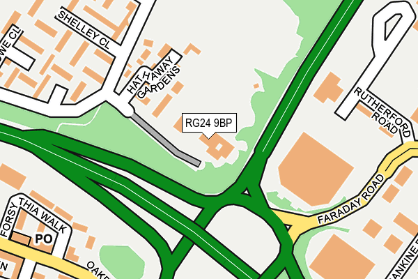
RG24 9BP is located in the Popley electoral ward, within the local authority district of Basingstoke and Deane and the English Parliamentary constituency of Basingstoke. The Sub Integrated Care Board (ICB) Location is NHS Hampshire and Isle of Wight ICB - D9Y0V and the police force is Hampshire. This postcode has been in use since June 2020.


GetTheData
Source: OS OpenMap – Local (Ordnance Survey)
Source: OS VectorMap District (Ordnance Survey)
Licence: Open Government Licence (requires attribution)
| Easting | 464598 |
| Northing | 153721 |
| Latitude | 51.278979 |
| Longitude | -1.075220 |
GetTheData
Source: Open Postcode Geo
Licence: Open Government Licence
| Country | England |
| Postcode District | RG24 |
➜ See where RG24 is on a map ➜ Where is Basingstoke? | |
GetTheData
Source: Land Registry Price Paid Data
Licence: Open Government Licence
Elevation or altitude of RG24 9BP as distance above sea level:
| Metres | Feet | |
|---|---|---|
| Elevation | 100m | 328ft |
Elevation is measured from the approximate centre of the postcode, to the nearest point on an OS contour line from OS Terrain 50, which has contour spacing of ten vertical metres.
➜ How high above sea level am I? Find the elevation of your current position using your device's GPS.
GetTheData
Source: Open Postcode Elevation
Licence: Open Government Licence
| Ward | Popley |
| Constituency | Basingstoke |
GetTheData
Source: ONS Postcode Database
Licence: Open Government Licence
| Shelley Close (Shakespeare Road) | Popley | 156m |
| Rutherford Road (Faraday Road) | Daneshill | 252m |
| Rutherford Road (Faraday Road) | Daneshill | 252m |
| Chineham Park (Reading Road) | Oakridge | 252m |
| Byron Close (Shakespeare Road) | Popley | 307m |
| Basingstoke Station | 1.4km |
GetTheData
Source: NaPTAN
Licence: Open Government Licence
GetTheData
Source: ONS Postcode Database
Licence: Open Government Licence


➜ Get more ratings from the Food Standards Agency
GetTheData
Source: Food Standards Agency
Licence: FSA terms & conditions
| Last Collection | |||
|---|---|---|---|
| Location | Mon-Fri | Sat | Distance |
| Longfellow Parade Post Office | 16:45 | 11:30 | 318m |
| Forsythia Walk | 17:00 | 12:00 | 350m |
| Tavener Close | 17:00 | 10:30 | 489m |
GetTheData
Source: Dracos
Licence: Creative Commons Attribution-ShareAlike
The below table lists the International Territorial Level (ITL) codes (formerly Nomenclature of Territorial Units for Statistics (NUTS) codes) and Local Administrative Units (LAU) codes for RG24 9BP:
| ITL 1 Code | Name |
|---|---|
| TLJ | South East (England) |
| ITL 2 Code | Name |
| TLJ3 | Hampshire and Isle of Wight |
| ITL 3 Code | Name |
| TLJ37 | North Hampshire |
| LAU 1 Code | Name |
| E07000084 | Basingstoke and Deane |
GetTheData
Source: ONS Postcode Directory
Licence: Open Government Licence
The below table lists the Census Output Area (OA), Lower Layer Super Output Area (LSOA), and Middle Layer Super Output Area (MSOA) for RG24 9BP:
| Code | Name | |
|---|---|---|
| OA | E00114599 | |
| LSOA | E01022540 | Basingstoke and Deane 007C |
| MSOA | E02004681 | Basingstoke and Deane 007 |
GetTheData
Source: ONS Postcode Directory
Licence: Open Government Licence
| RG24 9BF | Hathaway Gardens | 94m |
| RG24 9DA | Shelley Close | 216m |
| RG24 9DB | Burns Close | 224m |
| RG24 9BZ | Shelley Close | 260m |
| RG21 5RL | Forsythia Walk | 263m |
| RG24 9BW | Shakespeare Road | 265m |
| RG24 9BT | Milton Close | 266m |
| RG24 9BY | Milton Close | 267m |
| RG21 5RQ | Forsythia Walk | 306m |
| RG24 9DD | Marlowe Close | 314m |
GetTheData
Source: Open Postcode Geo; Land Registry Price Paid Data
Licence: Open Government Licence