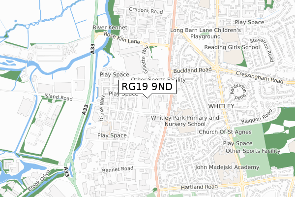
RG19 9ND is located in the Whitley electoral ward, within the unitary authority of Reading and the English Parliamentary constituency of Reading West. The Sub Integrated Care Board (ICB) Location is NHS Buckinghamshire, Oxfordshire and Berkshire West ICB - 15A and the police force is Thames Valley. This postcode has been in use since November 2019.


GetTheData
Source: OS Open Zoomstack (Ordnance Survey)
Licence: Open Government Licence (requires attribution)
Attribution: Contains OS data © Crown copyright and database right 2025
Source: Open Postcode Geo
Licence: Open Government Licence (requires attribution)
Attribution: Contains OS data © Crown copyright and database right 2025; Contains Royal Mail data © Royal Mail copyright and database right 2025; Source: Office for National Statistics licensed under the Open Government Licence v.3.0
| Easting | 471613 |
| Northing | 170786 |
| Latitude | 51.431562 |
| Longitude | -0.971231 |
GetTheData
Source: Open Postcode Geo
Licence: Open Government Licence
| Country | England |
| Postcode District | RG19 |
➜ See where RG19 is on a map ➜ Where is Reading? | |
GetTheData
Source: Land Registry Price Paid Data
Licence: Open Government Licence
| Ward | Whitley |
| Constituency | Reading West |
GetTheData
Source: ONS Postcode Database
Licence: Open Government Licence
| Gillette Way | Whitley | 93m |
| Manor Farm Road | Kennet Island | 127m |
| Gillette Way | Whitley | 130m |
| Manor Farm Road | Kennet Island | 159m |
| Whitley Park School (Basingstoke Road) | Whitley Wood | 197m |
| Reading West Station | 3km |
| Reading Station | 3km |
| Earley Station | 3.9km |
GetTheData
Source: NaPTAN
Licence: Open Government Licence
GetTheData
Source: ONS Postcode Database
Licence: Open Government Licence


➜ Get more ratings from the Food Standards Agency
GetTheData
Source: Food Standards Agency
Licence: FSA terms & conditions
| Last Collection | |||
|---|---|---|---|
| Location | Mon-Fri | Sat | Distance |
| Lindisfarne Way | 17:30 | 12:00 | 292m |
| Manor Farm | 17:00 | 13:00 | 295m |
| Post House | 17:15 | 13:15 | 1,150m |
GetTheData
Source: Dracos
Licence: Creative Commons Attribution-ShareAlike
The below table lists the International Territorial Level (ITL) codes (formerly Nomenclature of Territorial Units for Statistics (NUTS) codes) and Local Administrative Units (LAU) codes for RG19 9ND:
| ITL 1 Code | Name |
|---|---|
| TLJ | South East (England) |
| ITL 2 Code | Name |
| TLJ1 | Berkshire, Buckinghamshire and Oxfordshire |
| ITL 3 Code | Name |
| TLJ11 | Berkshire |
| LAU 1 Code | Name |
| E06000038 | Reading |
GetTheData
Source: ONS Postcode Directory
Licence: Open Government Licence
The below table lists the Census Output Area (OA), Lower Layer Super Output Area (LSOA), and Middle Layer Super Output Area (MSOA) for RG19 9ND:
| Code | Name | |
|---|---|---|
| OA | E00174531 | |
| LSOA | E01016442 | Reading 017E |
| MSOA | E02003405 | Reading 017 |
GetTheData
Source: ONS Postcode Directory
Licence: Open Government Licence
| RG2 0NA | Manor Park | 88m |
| RG2 0JH | Manor Farm Road | 116m |
| RG2 0JQ | Basingstoke Road | 184m |
| RG2 0FT | Puffin Way | 185m |
| RG2 0FP | Gweal Avenue | 190m |
| RG2 0FS | St Agnes Way | 209m |
| RG2 0FW | Gweal Avenue | 218m |
| RG2 0JA | Basingstoke Road | 226m |
| RG2 0FX | Havergate Way | 237m |
| RG2 0FZ | Longships Way | 237m |
GetTheData
Source: Open Postcode Geo; Land Registry Price Paid Data
Licence: Open Government Licence