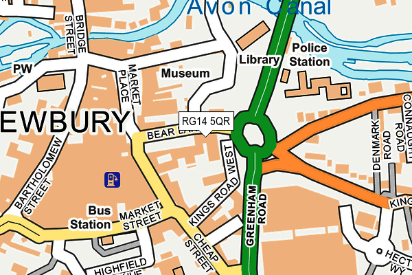
RG14 5QR is located in the Newbury Central electoral ward, within the unitary authority of West Berkshire and the English Parliamentary constituency of Newbury. The Sub Integrated Care Board (ICB) Location is NHS Buckinghamshire, Oxfordshire and Berkshire West ICB - 15A and the police force is Thames Valley. This postcode has been in use since January 1980.


GetTheData
Source: OS OpenMap – Local (Ordnance Survey)
Source: OS VectorMap District (Ordnance Survey)
Licence: Open Government Licence (requires attribution)
| Easting | 447290 |
| Northing | 167020 |
| Latitude | 51.400248 |
| Longitude | -1.321601 |
GetTheData
Source: Open Postcode Geo
Licence: Open Government Licence
| Country | England |
| Postcode District | RG14 |
➜ See where RG14 is on a map ➜ Where is Newbury? | |
GetTheData
Source: Land Registry Price Paid Data
Licence: Open Government Licence
Elevation or altitude of RG14 5QR as distance above sea level:
| Metres | Feet | |
|---|---|---|
| Elevation | 80m | 262ft |
Elevation is measured from the approximate centre of the postcode, to the nearest point on an OS contour line from OS Terrain 50, which has contour spacing of ten vertical metres.
➜ How high above sea level am I? Find the elevation of your current position using your device's GPS.
GetTheData
Source: Open Postcode Elevation
Licence: Open Government Licence
| Ward | Newbury Central |
| Constituency | Newbury |
GetTheData
Source: ONS Postcode Database
Licence: Open Government Licence
| Newbury Post Office (Cheap Street) | Newbury | 95m |
| Newbury Post Office (Cheap Street) | Newbury | 105m |
| Mill Lane | Newbury | 297m |
| Newbury Station (Station Road) | Newbury | 317m |
| Newbury Station (Station Road) | Newbury | 348m |
| Newbury Station | 0.3km |
| Newbury Racecourse Station | 1km |
GetTheData
Source: NaPTAN
Licence: Open Government Licence
GetTheData
Source: ONS Postcode Database
Licence: Open Government Licence


➜ Get more ratings from the Food Standards Agency
GetTheData
Source: Food Standards Agency
Licence: FSA terms & conditions
| Last Collection | |||
|---|---|---|---|
| Location | Mon-Fri | Sat | Distance |
| Newbury Delivery Office | 18:30 | 12:45 | 91m |
| The Wharf | 17:30 | 11:00 | 128m |
| Sainsbury Store | 17:30 | 12:00 | 198m |
GetTheData
Source: Dracos
Licence: Creative Commons Attribution-ShareAlike
The below table lists the International Territorial Level (ITL) codes (formerly Nomenclature of Territorial Units for Statistics (NUTS) codes) and Local Administrative Units (LAU) codes for RG14 5QR:
| ITL 1 Code | Name |
|---|---|
| TLJ | South East (England) |
| ITL 2 Code | Name |
| TLJ1 | Berkshire, Buckinghamshire and Oxfordshire |
| ITL 3 Code | Name |
| TLJ11 | Berkshire |
| LAU 1 Code | Name |
| E06000037 | West Berkshire |
GetTheData
Source: ONS Postcode Directory
Licence: Open Government Licence
The below table lists the Census Output Area (OA), Lower Layer Super Output Area (LSOA), and Middle Layer Super Output Area (MSOA) for RG14 5QR:
| Code | Name | |
|---|---|---|
| OA | E00082570 | |
| LSOA | E01016347 | West Berkshire 019C |
| MSOA | E02003385 | West Berkshire 019 |
GetTheData
Source: ONS Postcode Directory
Licence: Open Government Licence
| RG14 5QP | Wharf Road | 34m |
| RG14 5XR | Kings Road West | 60m |
| RG14 5BY | Kings Road West | 93m |
| RG14 5BX | Cheap Street | 97m |
| RG14 5BD | Market Place | 105m |
| RG14 5DH | Cheap Street | 140m |
| RG14 5AN | Wharf Street | 146m |
| RG14 5DJ | Carnegie Road | 146m |
| RG14 5AD | The Arcade | 180m |
| RG14 5DD | Cheap Street | 180m |
GetTheData
Source: Open Postcode Geo; Land Registry Price Paid Data
Licence: Open Government Licence