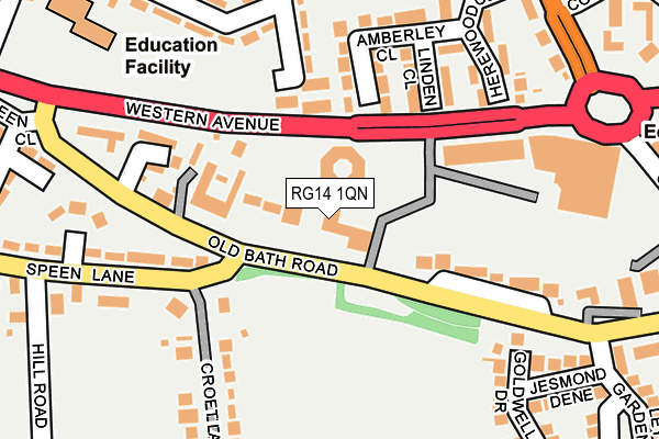
RG14 1QN is located in the Newbury Speen electoral ward, within the unitary authority of West Berkshire and the English Parliamentary constituency of Newbury. The Sub Integrated Care Board (ICB) Location is NHS Buckinghamshire, Oxfordshire and Berkshire West ICB - 15A and the police force is Thames Valley. This postcode has been in use since July 1995.


GetTheData
Source: OS OpenMap – Local (Ordnance Survey)
Source: OS VectorMap District (Ordnance Survey)
Licence: Open Government Licence (requires attribution)
| Easting | 446517 |
| Northing | 167736 |
| Latitude | 51.406749 |
| Longitude | -1.332618 |
GetTheData
Source: Open Postcode Geo
Licence: Open Government Licence
| Country | England |
| Postcode District | RG14 |
➜ See where RG14 is on a map ➜ Where is Newbury? | |
GetTheData
Source: Land Registry Price Paid Data
Licence: Open Government Licence
Elevation or altitude of RG14 1QN as distance above sea level:
| Metres | Feet | |
|---|---|---|
| Elevation | 90m | 295ft |
Elevation is measured from the approximate centre of the postcode, to the nearest point on an OS contour line from OS Terrain 50, which has contour spacing of ten vertical metres.
➜ How high above sea level am I? Find the elevation of your current position using your device's GPS.
GetTheData
Source: Open Postcode Elevation
Licence: Open Government Licence
| Ward | Newbury Speen |
| Constituency | Newbury |
GetTheData
Source: ONS Postcode Database
Licence: Open Government Licence
| Speen Lane Foot (Old Bath Road) | Newbury | 46m |
| Speen Lane Foot (Old Bath Road) | Newbury | 112m |
| Leys Gardens (Old Bath Road) | Newbury | 202m |
| Leys Gardens (Old Bath Road) | Newbury | 224m |
| Donnington Square (B4494 Oxford Road) | Donnington | 411m |
| Newbury Station | 1.2km |
| Newbury Racecourse Station | 2km |
GetTheData
Source: NaPTAN
Licence: Open Government Licence
GetTheData
Source: ONS Postcode Database
Licence: Open Government Licence


➜ Get more ratings from the Food Standards Agency
GetTheData
Source: Food Standards Agency
Licence: FSA terms & conditions
| Last Collection | |||
|---|---|---|---|
| Location | Mon-Fri | Sat | Distance |
| Donnington Square | 17:30 | 10:30 | 297m |
| Speenhamlandpost Office | 17:30 | 11:00 | 544m |
| Northbrook Street | 17:30 | 11:00 | 694m |
GetTheData
Source: Dracos
Licence: Creative Commons Attribution-ShareAlike
The below table lists the International Territorial Level (ITL) codes (formerly Nomenclature of Territorial Units for Statistics (NUTS) codes) and Local Administrative Units (LAU) codes for RG14 1QN:
| ITL 1 Code | Name |
|---|---|
| TLJ | South East (England) |
| ITL 2 Code | Name |
| TLJ1 | Berkshire, Buckinghamshire and Oxfordshire |
| ITL 3 Code | Name |
| TLJ11 | Berkshire |
| LAU 1 Code | Name |
| E06000037 | West Berkshire |
GetTheData
Source: ONS Postcode Directory
Licence: Open Government Licence
The below table lists the Census Output Area (OA), Lower Layer Super Output Area (LSOA), and Middle Layer Super Output Area (MSOA) for RG14 1QN:
| Code | Name | |
|---|---|---|
| OA | E00082396 | |
| LSOA | E01016311 | West Berkshire 012B |
| MSOA | E02003378 | West Berkshire 012 |
GetTheData
Source: ONS Postcode Directory
Licence: Open Government Licence
| RG14 1QL | Old Bath Road | 32m |
| RG14 1AG | Old Bath Road | 37m |
| RG14 1QA | Linden Close | 142m |
| RG14 1AR | Western Avenue | 151m |
| RG14 1PZ | Amberley Close | 157m |
| RG14 1QW | Posting House Mews | 162m |
| RG14 1RR | Croft Lane | 197m |
| RG14 1PY | Herewood Close | 216m |
| RG14 1QP | Old Bath Road | 227m |
| RG14 1TT | Digby Road | 244m |
GetTheData
Source: Open Postcode Geo; Land Registry Price Paid Data
Licence: Open Government Licence