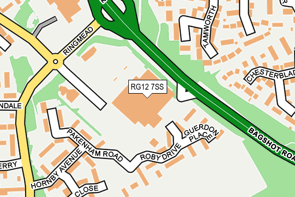
RG12 7SS is located in the Hanworth electoral ward, within the unitary authority of Bracknell Forest and the English Parliamentary constituency of Bracknell. The Sub Integrated Care Board (ICB) Location is NHS Frimley ICB - D4U1Y and the police force is Thames Valley. This postcode has been in use since July 1995.


GetTheData
Source: OS OpenMap – Local (Ordnance Survey)
Source: OS VectorMap District (Ordnance Survey)
Licence: Open Government Licence (requires attribution)
| Easting | 487738 |
| Northing | 166714 |
| Latitude | 51.392692 |
| Longitude | -0.740358 |
GetTheData
Source: Open Postcode Geo
Licence: Open Government Licence
| Country | England |
| Postcode District | RG12 |
➜ See where RG12 is on a map ➜ Where is Bracknell? | |
GetTheData
Source: Land Registry Price Paid Data
Licence: Open Government Licence
Elevation or altitude of RG12 7SS as distance above sea level:
| Metres | Feet | |
|---|---|---|
| Elevation | 90m | 295ft |
Elevation is measured from the approximate centre of the postcode, to the nearest point on an OS contour line from OS Terrain 50, which has contour spacing of ten vertical metres.
➜ How high above sea level am I? Find the elevation of your current position using your device's GPS.
GetTheData
Source: Open Postcode Elevation
Licence: Open Government Licence
| Ward | Hanworth |
| Constituency | Bracknell |
GetTheData
Source: ONS Postcode Database
Licence: Open Government Licence
| Sainsburys Car Park | Birch Hill | 61m |
| Sainsburys (Ringmead) | Birch Hill | 236m |
| Sainsburys (Ringmead) | Birch Hill | 248m |
| Fencote (Opladen Way) | Crown Wood | 276m |
| Fencote (Opladen Way) | Crown Wood | 286m |
| Martins Heron Station | 2km |
| Bracknell Station | 2.4km |
| Ascot Station | 4.7km |
GetTheData
Source: NaPTAN
Licence: Open Government Licence
GetTheData
Source: ONS Postcode Database
Licence: Open Government Licence


➜ Get more ratings from the Food Standards Agency
GetTheData
Source: Food Standards Agency
Licence: FSA terms & conditions
| Last Collection | |||
|---|---|---|---|
| Location | Mon-Fri | Sat | Distance |
| Sainsbury's | 17:30 | 11:15 | 102m |
| Birch Hill Post Office | 17:15 | 12:15 | 823m |
| Horndean Road (Shops) | 17:15 | 11:45 | 995m |
GetTheData
Source: Dracos
Licence: Creative Commons Attribution-ShareAlike
The below table lists the International Territorial Level (ITL) codes (formerly Nomenclature of Territorial Units for Statistics (NUTS) codes) and Local Administrative Units (LAU) codes for RG12 7SS:
| ITL 1 Code | Name |
|---|---|
| TLJ | South East (England) |
| ITL 2 Code | Name |
| TLJ1 | Berkshire, Buckinghamshire and Oxfordshire |
| ITL 3 Code | Name |
| TLJ11 | Berkshire |
| LAU 1 Code | Name |
| E06000036 | Bracknell Forest |
GetTheData
Source: ONS Postcode Directory
Licence: Open Government Licence
The below table lists the Census Output Area (OA), Lower Layer Super Output Area (LSOA), and Middle Layer Super Output Area (MSOA) for RG12 7SS:
| Code | Name | |
|---|---|---|
| OA | E00081960 | |
| LSOA | E01016217 | Bracknell Forest 010B |
| MSOA | E02003361 | Bracknell Forest 010 |
GetTheData
Source: ONS Postcode Directory
Licence: Open Government Licence
| RG12 7FQ | Phillip Copse | 88m |
| RG12 7FG | Roby Drive | 105m |
| RG12 7FH | Guerdon Place | 135m |
| RG12 0TU | Tamworth | 173m |
| RG12 7FF | Barry Square | 176m |
| RG12 7FB | Pakenham Road | 178m |
| RG12 7FD | Attebrouche Court | 211m |
| RG12 7FA | Hornby Avenue | 228m |
| RG12 0GP | Chesterblade Lane | 249m |
| RG12 7FE | Russell Close | 251m |
GetTheData
Source: Open Postcode Geo; Land Registry Price Paid Data
Licence: Open Government Licence