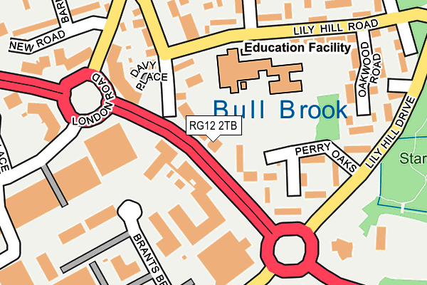
RG12 2TB is located in the Bullbrook electoral ward, within the unitary authority of Bracknell Forest and the English Parliamentary constituency of Bracknell. The Sub Integrated Care Board (ICB) Location is NHS Frimley ICB - D4U1Y and the police force is Thames Valley. This postcode has been in use since January 1980.


GetTheData
Source: OS OpenMap – Local (Ordnance Survey)
Source: OS VectorMap District (Ordnance Survey)
Licence: Open Government Licence (requires attribution)
| Easting | 488190 |
| Northing | 169198 |
| Latitude | 51.414951 |
| Longitude | -0.733246 |
GetTheData
Source: Open Postcode Geo
Licence: Open Government Licence
| Country | England |
| Postcode District | RG12 |
➜ See where RG12 is on a map ➜ Where is Bracknell? | |
GetTheData
Source: Land Registry Price Paid Data
Licence: Open Government Licence
Elevation or altitude of RG12 2TB as distance above sea level:
| Metres | Feet | |
|---|---|---|
| Elevation | 70m | 230ft |
Elevation is measured from the approximate centre of the postcode, to the nearest point on an OS contour line from OS Terrain 50, which has contour spacing of ten vertical metres.
➜ How high above sea level am I? Find the elevation of your current position using your device's GPS.
GetTheData
Source: Open Postcode Elevation
Licence: Open Government Licence
| Ward | Bullbrook |
| Constituency | Bracknell |
GetTheData
Source: ONS Postcode Database
Licence: Open Government Licence
| Ethyl Labs (London Road) | Bullbrook | 41m |
| Ethyl Labs (London Road) | Bullbrook | 61m |
| Mainprize Road (Lily Hill Road) | Bullbrook | 157m |
| New Road (Bay Road) | Bullbrook | 229m |
| Brants Bridge (Broad Lane) | Eastern Industrial Area | 237m |
| Martins Heron Station | 1km |
| Bracknell Station | 1.3km |
| Ascot Station | 4.1km |
GetTheData
Source: NaPTAN
Licence: Open Government Licence
GetTheData
Source: ONS Postcode Database
Licence: Open Government Licence


➜ Get more ratings from the Food Standards Agency
GetTheData
Source: Food Standards Agency
Licence: FSA terms & conditions
| Last Collection | |||
|---|---|---|---|
| Location | Mon-Fri | Sat | Distance |
| London Road | 16:00 | 11:45 | 448m |
| Beedon Drive | 16:00 | 12:00 | 892m |
| High Street P.o. Meter Box | 985m | ||
GetTheData
Source: Dracos
Licence: Creative Commons Attribution-ShareAlike
| Risk of RG12 2TB flooding from rivers and sea | High |
| ➜ RG12 2TB flood map | |
GetTheData
Source: Open Flood Risk by Postcode
Licence: Open Government Licence
The below table lists the International Territorial Level (ITL) codes (formerly Nomenclature of Territorial Units for Statistics (NUTS) codes) and Local Administrative Units (LAU) codes for RG12 2TB:
| ITL 1 Code | Name |
|---|---|
| TLJ | South East (England) |
| ITL 2 Code | Name |
| TLJ1 | Berkshire, Buckinghamshire and Oxfordshire |
| ITL 3 Code | Name |
| TLJ11 | Berkshire |
| LAU 1 Code | Name |
| E06000036 | Bracknell Forest |
GetTheData
Source: ONS Postcode Directory
Licence: Open Government Licence
The below table lists the Census Output Area (OA), Lower Layer Super Output Area (LSOA), and Middle Layer Super Output Area (MSOA) for RG12 2TB:
| Code | Name | |
|---|---|---|
| OA | E00081825 | |
| LSOA | E01032724 | Bracknell Forest 006F |
| MSOA | E02003357 | Bracknell Forest 006 |
GetTheData
Source: ONS Postcode Directory
Licence: Open Government Licence
| RG12 2NN | Bay Road | 80m |
| RG12 2UH | Perry Oaks | 98m |
| RG12 2NP | Bay Road | 143m |
| RG12 2NR | Bay Road | 179m |
| RG12 2SN | Lily Hill Road | 227m |
| RG12 2RD | Lily Hill Road | 228m |
| RG12 2SP | Oakwood Road | 231m |
| RG12 2TX | Oak Cottages | 238m |
| RG12 9TR | Rowley Close | 246m |
| RG12 2RG | Basemoors | 250m |
GetTheData
Source: Open Postcode Geo; Land Registry Price Paid Data
Licence: Open Government Licence