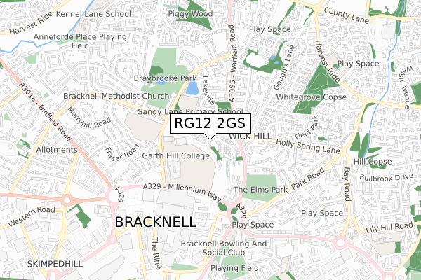
RG12 2GS is located in the Priestwood & Garth electoral ward, within the unitary authority of Bracknell Forest and the English Parliamentary constituency of Bracknell. The Sub Integrated Care Board (ICB) Location is NHS Frimley ICB - D4U1Y and the police force is Thames Valley. This postcode has been in use since May 2019.


GetTheData
Source: OS Open Zoomstack (Ordnance Survey)
Licence: Open Government Licence (requires attribution)
Attribution: Contains OS data © Crown copyright and database right 2025
Source: Open Postcode Geo
Licence: Open Government Licence (requires attribution)
Attribution: Contains OS data © Crown copyright and database right 2025; Contains Royal Mail data © Royal Mail copyright and database right 2025; Source: Office for National Statistics licensed under the Open Government Licence v.3.0
| Easting | 487285 |
| Northing | 169704 |
| Latitude | 51.419640 |
| Longitude | -0.746115 |
GetTheData
Source: Open Postcode Geo
Licence: Open Government Licence
| Country | England |
| Postcode District | RG12 |
➜ See where RG12 is on a map ➜ Where is Bracknell? | |
GetTheData
Source: Land Registry Price Paid Data
Licence: Open Government Licence
| Ward | Priestwood & Garth |
| Constituency | Bracknell |
GetTheData
Source: ONS Postcode Database
Licence: Open Government Licence
2024 15 MAY £538,000 |
2023 27 JUL £560,000 |
58, HURLEY DRIVE, BRACKNELL, RG12 2GS 2020 11 DEC £490,000 |
18, HURLEY DRIVE, BRACKNELL, RG12 2GS 2020 17 SEP £500,000 |
86, HURLEY DRIVE, BRACKNELL, RG12 2GS 2020 5 JUN £473,250 |
10, HURLEY DRIVE, BRACKNELL, RG12 2GS 2020 31 MAR £562,000 |
87, HURLEY DRIVE, BRACKNELL, RG12 2GS 2020 20 MAR £515,849 |
85, HURLEY DRIVE, BRACKNELL, RG12 2GS 2020 28 FEB £500,000 |
2, HURLEY DRIVE, BRACKNELL, RG12 2GS 2020 14 FEB £488,000 |
9, HURLEY DRIVE, BRACKNELL, RG12 2GS 2019 23 DEC £588,700 |
GetTheData
Source: HM Land Registry Price Paid Data
Licence: Contains HM Land Registry data © Crown copyright and database right 2025. This data is licensed under the Open Government Licence v3.0.
| Sandy Lane (Warfield Road) | Bracknell | 168m |
| Sandy Lane (Warfield Road) | Bracknell | 178m |
| Police Station (The Ring) | Bracknell | 236m |
| Goughs Lane (Holly Spring Lane) | Bracknell | 292m |
| Goughs Lane (Holly Spring Lane) | Bracknell | 301m |
| Bracknell Station | 0.8km |
| Martins Heron Station | 2km |
| Ascot Station | 5.1km |
GetTheData
Source: NaPTAN
Licence: Open Government Licence
| Percentage of properties with Next Generation Access | 100.0% |
| Percentage of properties with Superfast Broadband | 100.0% |
| Percentage of properties with Ultrafast Broadband | 54.5% |
| Percentage of properties with Full Fibre Broadband | 54.5% |
Superfast Broadband is between 30Mbps and 300Mbps
Ultrafast Broadband is > 300Mbps
| Percentage of properties unable to receive 2Mbps | 0.0% |
| Percentage of properties unable to receive 5Mbps | 0.0% |
| Percentage of properties unable to receive 10Mbps | 0.0% |
| Percentage of properties unable to receive 30Mbps | 0.0% |
GetTheData
Source: Ofcom
Licence: Ofcom Terms of Use (requires attribution)
GetTheData
Source: ONS Postcode Database
Licence: Open Government Licence


➜ Get more ratings from the Food Standards Agency
GetTheData
Source: Food Standards Agency
Licence: FSA terms & conditions
| Last Collection | |||
|---|---|---|---|
| Location | Mon-Fri | Sat | Distance |
| Wickhill | 16:00 | 11:15 | 231m |
| High Street P.o. Meter Box | 374m | ||
| High Street Post Office | 18:30 | 12:15 | 374m |
GetTheData
Source: Dracos
Licence: Creative Commons Attribution-ShareAlike
The below table lists the International Territorial Level (ITL) codes (formerly Nomenclature of Territorial Units for Statistics (NUTS) codes) and Local Administrative Units (LAU) codes for RG12 2GS:
| ITL 1 Code | Name |
|---|---|
| TLJ | South East (England) |
| ITL 2 Code | Name |
| TLJ1 | Berkshire, Buckinghamshire and Oxfordshire |
| ITL 3 Code | Name |
| TLJ11 | Berkshire |
| LAU 1 Code | Name |
| E06000036 | Bracknell Forest |
GetTheData
Source: ONS Postcode Directory
Licence: Open Government Licence
The below table lists the Census Output Area (OA), Lower Layer Super Output Area (LSOA), and Middle Layer Super Output Area (MSOA) for RG12 2GS:
| Code | Name | |
|---|---|---|
| OA | E00082047 | |
| LSOA | E01016238 | Bracknell Forest 003B |
| MSOA | E02003354 | Bracknell Forest 003 |
GetTheData
Source: ONS Postcode Directory
Licence: Open Government Licence
| RG12 2HY | Grange Road | 80m |
| RG12 2HZ | Grange Road | 88m |
| RG12 2LS | Shepherds Hill | 125m |
| RG12 2JA | Warfield Road | 132m |
| RG12 2HX | Willow Drive | 180m |
| RG12 2JB | Warfield Road | 181m |
| RG12 2JJ | Kenilworth Avenue | 234m |
| RG12 2JE | Kenilworth Avenue | 235m |
| RG12 2JG | Sandy Lane | 265m |
| RG12 2JD | Westbrook Gardens | 270m |
GetTheData
Source: Open Postcode Geo; Land Registry Price Paid Data
Licence: Open Government Licence