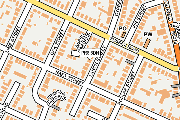
PR8 6DN is located in the Kew electoral ward, within the metropolitan district of Sefton and the English Parliamentary constituency of Southport. The Sub Integrated Care Board (ICB) Location is NHS Cheshire and Merseyside ICB - 01V and the police force is Merseyside. This postcode has been in use since June 2017.


GetTheData
Source: OS OpenMap – Local (Ordnance Survey)
Source: OS VectorMap District (Ordnance Survey)
Licence: Open Government Licence (requires attribution)
| Easting | 335096 |
| Northing | 415072 |
| Latitude | 53.628152 |
| Longitude | -2.982884 |
GetTheData
Source: Open Postcode Geo
Licence: Open Government Licence
| Country | England |
| Postcode District | PR8 |
➜ See where PR8 is on a map ➜ Where is Southport? | |
GetTheData
Source: Land Registry Price Paid Data
Licence: Open Government Licence
| Ward | Kew |
| Constituency | Southport |
GetTheData
Source: ONS Postcode Database
Licence: Open Government Licence
| Blowick Moss Industrial Estate | Blowick Moss | 294m |
| Ruddington Road (Folkestone Road) | Kew | 303m |
| Ruddington Road (Folkestone Road) | Kew | 317m |
| Blowick Moss Industrial Estate (Wight Moss Way) | Blowick Moss | 318m |
| Hythe Close (Town Lane) | Kew | 353m |
| Meols Cop Station | 2.1km |
| Birkdale Station | 2.2km |
| Southport Station | 2.4km |
GetTheData
Source: NaPTAN
Licence: Open Government Licence
GetTheData
Source: ONS Postcode Database
Licence: Open Government Licence


➜ Get more ratings from the Food Standards Agency
GetTheData
Source: Food Standards Agency
Licence: FSA terms & conditions
| Last Collection | |||
|---|---|---|---|
| Location | Mon-Fri | Sat | Distance |
| Southport Delivery Office | 17:00 | 12:00 | 278m |
| Ovington Drive Post Office | 17:45 | 11:30 | 397m |
| 1 Cheltenham Way | 16:30 | 11:30 | 671m |
GetTheData
Source: Dracos
Licence: Creative Commons Attribution-ShareAlike
The below table lists the International Territorial Level (ITL) codes (formerly Nomenclature of Territorial Units for Statistics (NUTS) codes) and Local Administrative Units (LAU) codes for PR8 6DN:
| ITL 1 Code | Name |
|---|---|
| TLD | North West (England) |
| ITL 2 Code | Name |
| TLD7 | Merseyside |
| ITL 3 Code | Name |
| TLD73 | Sefton |
| LAU 1 Code | Name |
| E08000014 | Sefton |
GetTheData
Source: ONS Postcode Directory
Licence: Open Government Licence
The below table lists the Census Output Area (OA), Lower Layer Super Output Area (LSOA), and Middle Layer Super Output Area (MSOA) for PR8 6DN:
| Code | Name | |
|---|---|---|
| OA | E00035465 | |
| LSOA | E01007002 | Sefton 008F |
| MSOA | E02001436 | Sefton 008 |
GetTheData
Source: ONS Postcode Directory
Licence: Open Government Licence
| PR8 6QB | Cheriton Park | 133m |
| PR8 6XT | Winston Crescent | 170m |
| PR8 6UJ | Westwood Close | 175m |
| PR8 6US | Sangness Drive | 208m |
| PR8 5PP | Folkestone Road | 223m |
| PR8 6UP | Malham Close | 247m |
| PR8 6UD | Ardleigh Avenue | 250m |
| PR8 6UR | Foxdale Close | 296m |
| PR8 6LL | Edenfield Close | 303m |
| PR8 6UL | Ingleton Road | 306m |
GetTheData
Source: Open Postcode Geo; Land Registry Price Paid Data
Licence: Open Government Licence