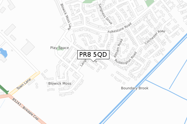
PR8 5QD is located in the Kew electoral ward, within the metropolitan district of Sefton and the English Parliamentary constituency of Southport. The Sub Integrated Care Board (ICB) Location is NHS Cheshire and Merseyside ICB - 01V and the police force is Merseyside. This postcode has been in use since June 2019.


GetTheData
Source: OS Open Zoomstack (Ordnance Survey)
Licence: Open Government Licence (requires attribution)
Attribution: Contains OS data © Crown copyright and database right 2025
Source: Open Postcode Geo
Licence: Open Government Licence (requires attribution)
Attribution: Contains OS data © Crown copyright and database right 2025; Contains Royal Mail data © Royal Mail copyright and database right 2025; Source: Office for National Statistics licensed under the Open Government Licence v.3.0
| Easting | 335290 |
| Northing | 414847 |
| Latitude | 53.626154 |
| Longitude | -2.979904 |
GetTheData
Source: Open Postcode Geo
Licence: Open Government Licence
| Country | England |
| Postcode District | PR8 |
➜ See where PR8 is on a map ➜ Where is Southport? | |
GetTheData
Source: Land Registry Price Paid Data
Licence: Open Government Licence
| Ward | Kew |
| Constituency | Southport |
GetTheData
Source: ONS Postcode Database
Licence: Open Government Licence
2025 21 JAN £360,000 |
2025 8 JAN £265,000 |
2024 21 OCT £255,000 |
4, LANGFORD DRIVE, SOUTHPORT, PR8 5QD 2021 24 SEP £280,000 |
2, LANGFORD DRIVE, SOUTHPORT, PR8 5QD 2021 30 JUL £302,500 |
67, LANGFORD DRIVE, SOUTHPORT, PR8 5QD 2021 5 MAR £329,995 |
30, LANGFORD DRIVE, SOUTHPORT, PR8 5QD 2021 26 FEB £335,000 |
32, LANGFORD DRIVE, SOUTHPORT, PR8 5QD 2021 12 FEB £295,000 |
71, LANGFORD DRIVE, SOUTHPORT, PR8 5QD 2021 29 JAN £260,000 |
36, LANGFORD DRIVE, SOUTHPORT, PR8 5QD 2021 29 JAN £260,000 |
GetTheData
Source: HM Land Registry Price Paid Data
Licence: Contains HM Land Registry data © Crown copyright and database right 2025. This data is licensed under the Open Government Licence v3.0.
| Ruddington Road (Folkestone Road) | Kew | 223m |
| Ruddington Road (Folkestone Road) | Kew | 253m |
| Ingleton Road (Ovington Drive) | Kew | 415m |
| Ingleton Road (Ovington Drive) | Kew | 419m |
| County Boundary (Birkdale Cop) | Blowick Moss | 444m |
| Meols Cop Station | 2.3km |
| Birkdale Station | 2.4km |
| Southport Station | 2.7km |
GetTheData
Source: NaPTAN
Licence: Open Government Licence
| Percentage of properties with Next Generation Access | 80.6% |
| Percentage of properties with Superfast Broadband | 80.6% |
| Percentage of properties with Ultrafast Broadband | 77.4% |
| Percentage of properties with Full Fibre Broadband | 64.5% |
Superfast Broadband is between 30Mbps and 300Mbps
Ultrafast Broadband is > 300Mbps
| Percentage of properties unable to receive 2Mbps | 0.0% |
| Percentage of properties unable to receive 5Mbps | 0.0% |
| Percentage of properties unable to receive 10Mbps | 0.0% |
| Percentage of properties unable to receive 30Mbps | 0.0% |
GetTheData
Source: Ofcom
Licence: Ofcom Terms of Use (requires attribution)
GetTheData
Source: ONS Postcode Database
Licence: Open Government Licence


➜ Get more ratings from the Food Standards Agency
GetTheData
Source: Food Standards Agency
Licence: FSA terms & conditions
| Last Collection | |||
|---|---|---|---|
| Location | Mon-Fri | Sat | Distance |
| Ovington Drive Post Office | 17:45 | 11:30 | 400m |
| Southport Delivery Office | 17:00 | 12:00 | 456m |
| 1 Cheltenham Way | 16:30 | 11:30 | 772m |
GetTheData
Source: Dracos
Licence: Creative Commons Attribution-ShareAlike
The below table lists the International Territorial Level (ITL) codes (formerly Nomenclature of Territorial Units for Statistics (NUTS) codes) and Local Administrative Units (LAU) codes for PR8 5QD:
| ITL 1 Code | Name |
|---|---|
| TLD | North West (England) |
| ITL 2 Code | Name |
| TLD7 | Merseyside |
| ITL 3 Code | Name |
| TLD73 | Sefton |
| LAU 1 Code | Name |
| E08000014 | Sefton |
GetTheData
Source: ONS Postcode Directory
Licence: Open Government Licence
The below table lists the Census Output Area (OA), Lower Layer Super Output Area (LSOA), and Middle Layer Super Output Area (MSOA) for PR8 5QD:
| Code | Name | |
|---|---|---|
| OA | E00035465 | |
| LSOA | E01007002 | Sefton 008F |
| MSOA | E02001436 | Sefton 008 |
GetTheData
Source: ONS Postcode Directory
Licence: Open Government Licence
| PR8 6XT | Winston Crescent | 145m |
| PR8 6XD | Ruddington Road | 168m |
| PR8 6XL | Altham Road | 171m |
| PR8 5PP | Folkestone Road | 212m |
| PR8 6XR | Markham Drive | 212m |
| PR8 6US | Sangness Drive | 258m |
| PR8 6UR | Foxdale Close | 285m |
| PR8 6XH | Bracebridge Drive | 317m |
| PR8 6XB | Nuthall Road | 322m |
| PR8 6QB | Cheriton Park | 324m |
GetTheData
Source: Open Postcode Geo; Land Registry Price Paid Data
Licence: Open Government Licence