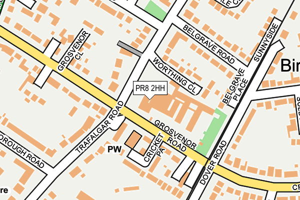
PR8 2HH is located in the Duke's electoral ward, within the metropolitan district of Sefton and the English Parliamentary constituency of Southport. The Sub Integrated Care Board (ICB) Location is NHS Cheshire and Merseyside ICB - 01V and the police force is Merseyside. This postcode has been in use since January 1980.


GetTheData
Source: OS OpenMap – Local (Ordnance Survey)
Source: OS VectorMap District (Ordnance Survey)
Licence: Open Government Licence (requires attribution)
| Easting | 332626 |
| Northing | 415370 |
| Latitude | 53.630502 |
| Longitude | -3.020292 |
GetTheData
Source: Open Postcode Geo
Licence: Open Government Licence
| Country | England |
| Postcode District | PR8 |
➜ See where PR8 is on a map ➜ Where is Southport? | |
GetTheData
Source: Land Registry Price Paid Data
Licence: Open Government Licence
Elevation or altitude of PR8 2HH as distance above sea level:
| Metres | Feet | |
|---|---|---|
| Elevation | 10m | 33ft |
Elevation is measured from the approximate centre of the postcode, to the nearest point on an OS contour line from OS Terrain 50, which has contour spacing of ten vertical metres.
➜ How high above sea level am I? Find the elevation of your current position using your device's GPS.
GetTheData
Source: Open Postcode Elevation
Licence: Open Government Licence
| Ward | Duke's |
| Constituency | Southport |
GetTheData
Source: ONS Postcode Database
Licence: Open Government Licence
| Trafalgar Road (Grosvenor Road) | Birkdale | 46m |
| Trafalgar Road (Grosvenor Road) | Birkdale | 87m |
| Burlington Road (Crescent Road) | Birkdale | 201m |
| Crescent Road (Burlington Road) | Birkdale | 316m |
| Waterloo Road (Grosvenor Road) | Birkdale | 325m |
| Birkdale Station | 0.6km |
| Hillside Station | 1km |
| Southport Station | 2.1km |
GetTheData
Source: NaPTAN
Licence: Open Government Licence
GetTheData
Source: ONS Postcode Database
Licence: Open Government Licence


➜ Get more ratings from the Food Standards Agency
GetTheData
Source: Food Standards Agency
Licence: FSA terms & conditions
| Last Collection | |||
|---|---|---|---|
| Location | Mon-Fri | Sat | Distance |
| 16 Regent Road | 16:00 | 11:00 | 144m |
| Gainsborough Road | 16:30 | 11:00 | 232m |
| 29 Grosvenor Road | 16:00 | 11:30 | 290m |
GetTheData
Source: Dracos
Licence: Creative Commons Attribution-ShareAlike
The below table lists the International Territorial Level (ITL) codes (formerly Nomenclature of Territorial Units for Statistics (NUTS) codes) and Local Administrative Units (LAU) codes for PR8 2HH:
| ITL 1 Code | Name |
|---|---|
| TLD | North West (England) |
| ITL 2 Code | Name |
| TLD7 | Merseyside |
| ITL 3 Code | Name |
| TLD73 | Sefton |
| LAU 1 Code | Name |
| E08000014 | Sefton |
GetTheData
Source: ONS Postcode Directory
Licence: Open Government Licence
The below table lists the Census Output Area (OA), Lower Layer Super Output Area (LSOA), and Middle Layer Super Output Area (MSOA) for PR8 2HH:
| Code | Name | |
|---|---|---|
| OA | E00035338 | |
| LSOA | E01006974 | Sefton 009F |
| MSOA | E02001437 | Sefton 009 |
GetTheData
Source: ONS Postcode Directory
Licence: Open Government Licence
| PR8 2HJ | Cricket Path | 106m |
| PR8 2EW | Trafalgar Road | 107m |
| PR8 2EN | Trafalgar Road | 108m |
| PR8 2HB | Worthing Close | 109m |
| PR8 2ER | Grosvenor Road | 127m |
| PR8 2EF | Belgrave Place | 146m |
| PR8 2HF | Trafalgar Road | 164m |
| PR8 2TJ | Grosvenor Close | 170m |
| PR8 2LH | Grosvenor Gardens | 174m |
| PR8 2DZ | Belgrave Road | 186m |
GetTheData
Source: Open Postcode Geo; Land Registry Price Paid Data
Licence: Open Government Licence