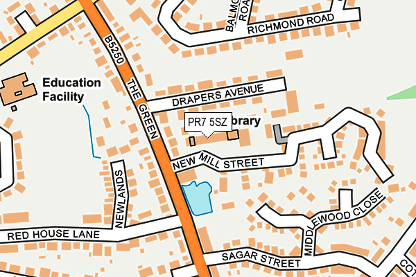
PR7 5SZ is located in the Eccleston, Heskin & Charnock Richard electoral ward, within the local authority district of Chorley and the English Parliamentary constituency of South Ribble. The Sub Integrated Care Board (ICB) Location is NHS Lancashire and South Cumbria ICB - 00X and the police force is Lancashire. This postcode has been in use since January 1980.


GetTheData
Source: OS OpenMap – Local (Ordnance Survey)
Source: OS VectorMap District (Ordnance Survey)
Licence: Open Government Licence (requires attribution)
| Easting | 352222 |
| Northing | 416871 |
| Latitude | 53.646151 |
| Longitude | -2.724228 |
GetTheData
Source: Open Postcode Geo
Licence: Open Government Licence
| Country | England |
| Postcode District | PR7 |
➜ See where PR7 is on a map ➜ Where is Eccleston? | |
GetTheData
Source: Land Registry Price Paid Data
Licence: Open Government Licence
Elevation or altitude of PR7 5SZ as distance above sea level:
| Metres | Feet | |
|---|---|---|
| Elevation | 30m | 98ft |
Elevation is measured from the approximate centre of the postcode, to the nearest point on an OS contour line from OS Terrain 50, which has contour spacing of ten vertical metres.
➜ How high above sea level am I? Find the elevation of your current position using your device's GPS.
GetTheData
Source: Open Postcode Elevation
Licence: Open Government Licence
| Ward | Eccleston, Heskin & Charnock Richard |
| Constituency | South Ribble |
GetTheData
Source: ONS Postcode Database
Licence: Open Government Licence
| Lawrence Lane (The Green) | Eccleston | 218m |
| Doctors Lane (The Green) | Eccleston | 222m |
| Institute (The Green) | Eccleston Green | 236m |
| Institute (The Green) | Eccleston Green | 250m |
| Marsden Close (Doctors Lane) | Eccleston | 285m |
| Euxton Balshaw Lane Station | 3.8km |
| Croston Station | 4.3km |
| Buckshaw Parkway Station | 5.2km |
GetTheData
Source: NaPTAN
Licence: Open Government Licence
Estimated total energy consumption in PR7 5SZ by fuel type, 2015.
| Consumption (kWh) | 149,702 |
|---|---|
| Meter count | 11 |
| Mean (kWh/meter) | 13,609 |
| Median (kWh/meter) | 5,914 |
GetTheData
Source: Postcode level gas estimates: 2015 (experimental)
Source: Postcode level electricity estimates: 2015 (experimental)
Licence: Open Government Licence
GetTheData
Source: ONS Postcode Database
Licence: Open Government Licence


➜ Get more ratings from the Food Standards Agency
GetTheData
Source: Food Standards Agency
Licence: FSA terms & conditions
| Last Collection | |||
|---|---|---|---|
| Location | Mon-Fri | Sat | Distance |
| Eccleston Post Office | 17:15 | 11:00 | 37m |
| 263 The Green, Eccleston | 17:15 | 11:00 | 349m |
| Lydiate Lane, Eccleston | 16:15 | 11:15 | 1,734m |
GetTheData
Source: Dracos
Licence: Creative Commons Attribution-ShareAlike
The below table lists the International Territorial Level (ITL) codes (formerly Nomenclature of Territorial Units for Statistics (NUTS) codes) and Local Administrative Units (LAU) codes for PR7 5SZ:
| ITL 1 Code | Name |
|---|---|
| TLD | North West (England) |
| ITL 2 Code | Name |
| TLD4 | Lancashire |
| ITL 3 Code | Name |
| TLD47 | Chorley and West Lancashire |
| LAU 1 Code | Name |
| E07000118 | Chorley |
GetTheData
Source: ONS Postcode Directory
Licence: Open Government Licence
The below table lists the Census Output Area (OA), Lower Layer Super Output Area (LSOA), and Middle Layer Super Output Area (MSOA) for PR7 5SZ:
| Code | Name | |
|---|---|---|
| OA | E00126706 | |
| LSOA | E01024966 | Chorley 011E |
| MSOA | E02005199 | Chorley 011 |
GetTheData
Source: ONS Postcode Directory
Licence: Open Government Licence
| PR7 5SU | The Green | 75m |
| PR7 5SY | Drapers Avenue | 80m |
| PR7 5SX | The Green | 110m |
| PR7 5SR | Richmond Road | 154m |
| PR7 5FS | New Mill Street | 156m |
| PR7 5RU | Newlands | 158m |
| PR7 5FT | New Mill Street | 162m |
| PR7 5QG | Middlewood Close | 179m |
| PR7 5TE | The Green | 196m |
| PR7 5ST | Balmoral Road | 201m |
GetTheData
Source: Open Postcode Geo; Land Registry Price Paid Data
Licence: Open Government Licence